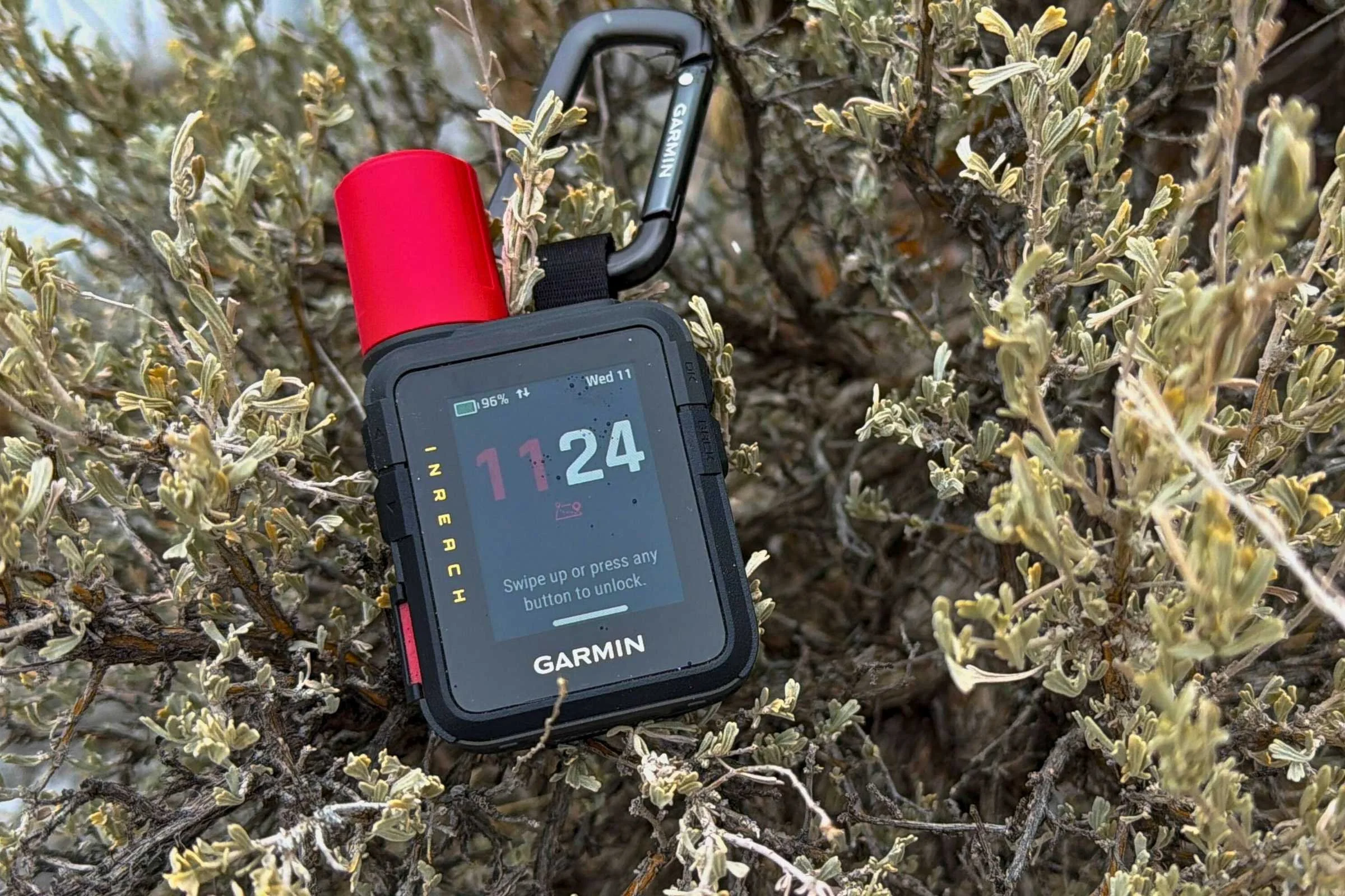
Garmin inReach Messenger Review
Longer battery, more affordable, and the easiest to use Garmin Satellite Communicator Device

November 22nd, 2024
Home > Gear Reviews > Electronics
Our Verdict
The Garmin inReach Messenger fills a much-needed niche in Garmin’s satellite communicator device lineup. It’s a fully SOS-capable device that also has two-way messaging and email. By dropping some of the mapping and navigation abilities of other Garmin devices, it’s more affordable and easier to use.
One feature that makes the inReach Messenger special among Garmin devices is that it uses cellular service when available and iridium satellites when cell service isn’t available. Using these networks, it can send out SOS emergency messages, GPS coordinates, two-way messaging, and emails.
The Messenger has a long battery life, nearly twice as long as the inReach Mini 2. Another feature we liked is that it can also be a reverse charger if you need to boost your cell phone battery (too often, rescues are interrupted when a phone battery dies).
Many people don’t need the navigation and mapping capability of the Garmin inReach Mini 2, the Garmin Montana, Garmin GPSMAP, or the (now discontinued) Garmin inReach Explorer, yet they want more than just a push-button rescue device. The Messenger is less expensive and easier to use than other Garmin communicator devices but without as many mapping and navigation features.
Like other devices, you can initiate tracking and share your route with others. It also has a weather forecast feature that uses your current location or any location you add.
All of this comes in a package that weighs less than 4 oz and is only 3 inches high.
While it isn't the most sophisticated in Garmin’s lineup, it's less expensive and the easiest to set up and use. It’s best for the day hiker, the traveler, off-road adventurers and campers, and anyone who wants the ability to send out an SOS or stay in touch with friends and family when their activity may take them beyond cellular range.
We spent a year testing it in the mountains of Colorado to inform this review.
Compare Prices of the Garmin inReach Messenger
We create reader-supported, objective gear reviews independently selected by our editors. This story may contain affiliate links, which help fund our website. When you click on the links to purchase gear, we may get a commission, without costing you an extra cent. Thank you for supporting our work and mission of outdoor coverage for every body! Learn more.
Garmin inReach Messenger Specifications
Size: 3.1" x 2.5" x 0.9" ( 7.8 x 6.4 x 2.3 cm)
Weight: 3.78 ounces (107.16 grams)
Battery Life: See table
Waterproof Rating: IPX7 (immersion in water up to 1 meter for up to 30 minutes)
Charging: USB-C
Coverage Area: Worldwide
Price: $300
SATELLITE COMMUNICATOR COMPARISON TABLE
| DEVICE | MSRP* | WEIGHT (oz) | DIMENSIONS (in) | COVERAGE | WATERPROOF RATING | BATTERY TYPE | BATTERY LIFE | SMARTPHONE INTEGRATION? | SUBSCRIPTION REQUIRED? |
|---|---|---|---|---|---|---|---|---|---|
| Garmin inReach Messenger | $300 | 4.0 | 3.1 x 2.5 x 0.9 | Global | IPX7 | Rechargeable lithium ion | Up to 28 days in 10-minute tracking mode | ||
| Garmin inReach Messenger Plus | $500 | 4.0 | 3.1 x 2.5 x 0.9 | Global | IPX7 | Rechargeable lithium ion | Up to 25 days in 10-minute tracking mode | ||
| Garmin inReach Mini 3 | $449 | 4.3 | 3.9 x 2.2 x 1.1 | Global | IP67 | Rechargeable lithium ion | Up to 14 days in 10-minute tracking mode | ||
| Garmin GPSMAP 67i Handheld | $600 | 8.1 | 6.4 x 2.5 x 1.4 | Global | IPX7 | Rechargeable lithium ion | Up to 17 days in Expedition Mode | ||
| ACR Electronics Bivy Stick | $200 | 3.4 | 6.8 x 3.1 x 1.8 | Global | IPX7 | Rechargable lithium ion | Average 5 days |
Types of Satellite Communication Devices
All satellite communication devices – no matter who they are manufactured by – can send out an SOS for rescue.
The most basic SOS devices are Personal Locator Beacons (PLBs). If you get into trouble, press a button, and your SOS message goes to the appropriate satellite network and is passed on to the rescue service closest to your location. A Personal Locator Beacon is the least expensive emergency device, too.
At the other end of the spectrum are more sophisticated satellite communicators that can send SOSs, but they also serve as handheld GPS units (with mapping and navigation capabilities), allow for 2-way texting and emailing. The newest models are even capable of voice messaging and photo sharing. The ability to have an interactive SOS and let Search and Rescue know about your condition can help them get to you quickly and better allocate resources that can help you.
Unlike PLBs, satellite communicators require an active subscription plan. Learn more about PLBs and satellite communicators here.

The author, Dean Krakel, skiing with the Garmin inReach Messenger satellite communicator device in Crested Butte, Colorado. Photo courtesy Dean Krakel.
target Users
The Garmin inReach Messenger is for people who want to carry a satellite communicator capable of sending an SOS, checking the weather, and doing two-way texting, messaging, and emailing. But it's also for people who don’t want or need the sophisticated navigation and mapping features available on more expensive units.
Like the Garmin inReach Mini 2, it’s easier to use when paired with a phone and the Garmin Messenger App. The app is not required as all its features can be used as a standalone device without the aid of a smartphone. Still, it’s easier to operate if you carry a smartphone.
If you've got an inReach Mini or Mini 2 already and find it easy enough to use, we wouldn't recommend switching it out.
But if you're in the market for a satellite messenger and don't need navigation capabilities, we'd give the inReach Messenger a serious look.
Easy-to-read weather forecasts are one of the benefits of the Garmin system. Tested side-by-side with the Garmin inReach Mini, we were able to get weather reports faster on the inReach Messenger.
Features
SOS
For starters, the SOS function on all Garmin inReach devices only works if you subscribe to satellite service from Garmin. More about subscriptions below. Also, the device must have a clear view of the sky.
The SOS button is on the unit’s right side, clearly marked and covered by an easy-to-flip open plastic cover to prevent an accidental pushing of the button.
Pressing the SOS button works whether the unit is powered on or off. The SOS begins with a countdown and sends a message with your location through Garmin’s Iridium satellite network to the Garmin International Emergency Response Coordination Center (IERCC) to request help.
The Garmin IERCC will send you a message to which you will reply if capable. Capable or not, the IERCC will initiate a rescue, contacting the rescue agency nearest your location. The device allows you to communicate with rescuers during the rescue.
The SOS works through the Garmin Messenger phone app as well.
SOS works with the unit powered off.
As a person who has been accidentally rescued because of a faulty SOS button, I really like that the device has an easy way to cancel an SOS while rescue is in progress. There is also a way to send a custom SOS message, which is helpful if you need to describe an injury to rescuers or give the particulars of the situation to aid in the manner of rescue.
After you send out an SOS, the device updates your location every minute for ten minutes. After 10 minutes, it updates your location once every ten minutes.
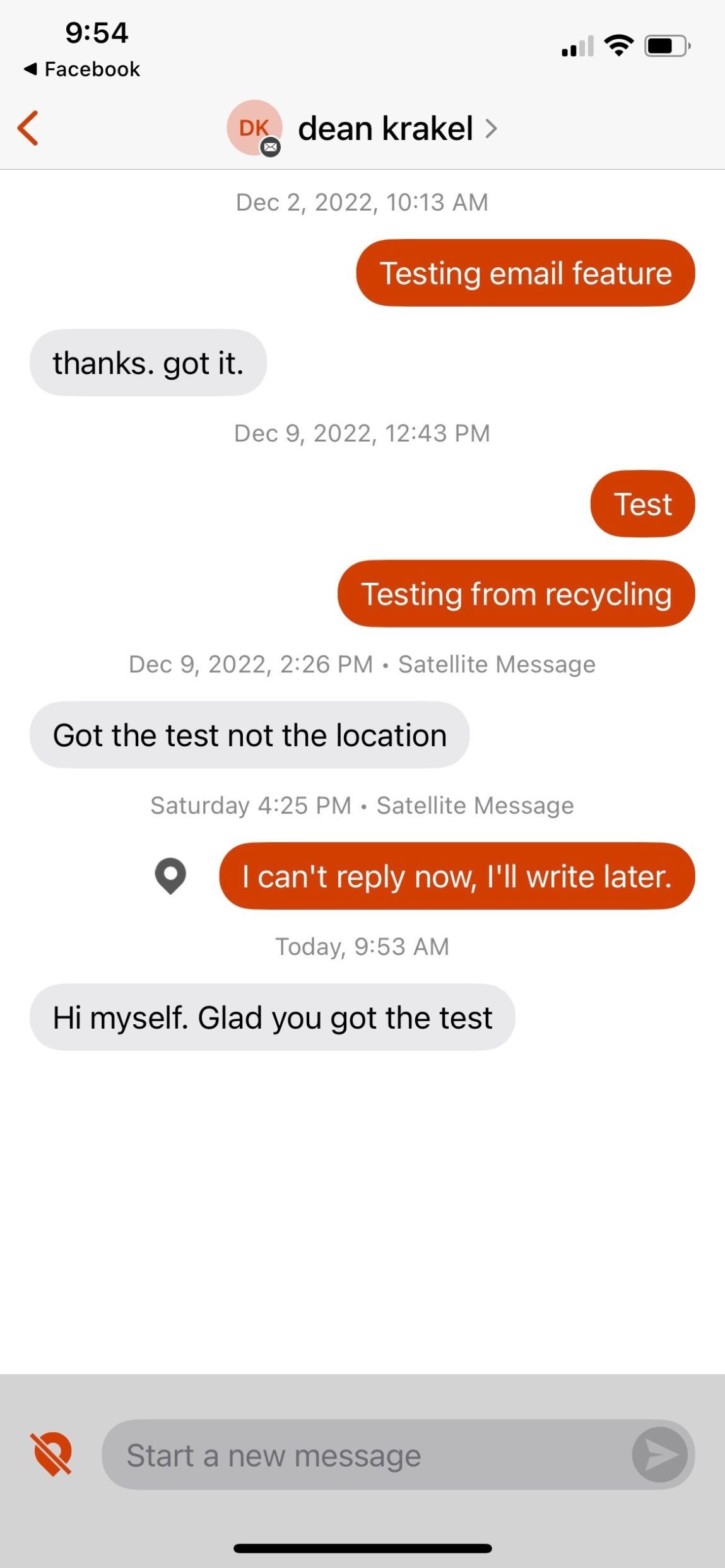
Texting through the Garmin Messenger smartphone app.
Text Messages (SMS and Email)
I used the phone app to send text messages and emails. Messaging and emailing can be done on the device itself, but the screen is small (1 inch by 2 inches approximately), and creating a message requires patience. Unlike two-way message devices like the SPOT X, there is no dedicated keyboard.
The Garmin Messenger app is just so much easier to use. Texting was easy, as was emailing. Receiving was just as fluid as sending.
The inReach Messenger can use cell towers and satellite networks; when you send a message, it seamlessly chooses which one to use. Some texts I sent were regular texts, and others went by satellite when I was out of service. It’s not a decision the user gets to make.
When you send a message, it checks for new messages for 10 minutes and then once every hour after that. If you use the tracking feature, it checks for messages at your tracking interval.
Again, if you’re using the phone app, it’s easy to check messages by just tapping on the message icon.
Text Messages to Other Garmin Devices
To see whether the it works with other Garmin handhelds, I used it to communicate with my son, who was using an inReach Mini and hiking in the mountains 30 miles from my location. We could communicate without any complication and in near real-time. I also used it to text my son’s girlfriend on her cell phone to update her on his progress. Again, it worked seamlessly across both platforms.
Group Text Messages
You can send out group text messages. However, responses are individual, so there is no “group think.”
Weather
Weather forecasts were an awesome feature. Getting the weather report was faster than when I checked the weather with my Garmin inReach Mini. Again, I used the phone app so I could utilize the larger screen.
The first time I checked the weather, the response took over 30 minutes — possibly due to cloud cover as it was storming. The next morning, with clear skies, I received an accurate weather forecast within 5 minutes. In a recent side-by-side comparison, from the same location at close to the same time, a weather forecast on my Garmin Mini took 6 minutes to receive. On the Messenger, the weather forecast took less than a minute.
WiFi, Cellular, and Satellite Connectivity
Again, this is where it excels — seamlessly switching between cellular coverage and satellite connectivity. I never had any trouble using wifi or Bluetooth communication.
Worldwide Coverage
The device has worldwide coverage, as do all satellite communication devices.
Location Sharing
Although it does not have navigation capability, it does have a tracking feature that will share your location when you send out check-ins or texts on Garmin Explore’s map page: https://explore.garmin.com/Map.
Any contact you email or text will receive your location pinpointed on that map. It is not necessary for your contacts to have a Garmin connection or app to see the location you have shared.

One of the advantages of the inReach Messenger over other satellite communicator devices is the ability to group text. In this image, the author sends texts, including a group text to Sean +5 other people.

An example of how the inReach Messenger can send email updates.
Reverse Charging
This nifty feature is easy to use. Reverse charging is used when a cell phone is too low in power to send messages or an emergency SOS. It essentially turns the unit into a battery bank, allowing you to charge your phone. The reverse charge feature will not let the unit’s power level go lower than 25%. It will automatically shut off the reverse charging feature after 20 minutes.
Satellite Networks
Garmin uses the Iridium satellite network. You can learn more about networks in our Garmin Instinct 2 guide.
Navigating Using TracBack®
According to Garmin’s instructions, a user should be able to use the TracBack to retrace their steps back to a starting point. From the device’s main menu, a user scrolls through the options, selecting TracBack. After hitting OK, the user scrolls through the recorded points and picks one to navigate back to. There’s an option to “follow path” or to navigate back in a “Straight Line,” and then the compass arrow, distance to the next course point, and distance remaining to your destination appear.
I never had any success with this feature. A user could definitely use TracBack in an emergency, as it’s better than nothing. Otherwise, the screen is too small to clearly see what points you are supposed to be navigating back to. I found the “follow the path” back vague and not exact — the compass needle only works when you’re moving. So, if you stop to check things out, the compass needle goes away.
There is no following the breadcrumbs back. There is no guidance to let you know when you’re off the path other than the compass (keep moving!) needle pointing in the direction you’re supposed to be going, and there is no “picture” of the path so you can make visual adjustments. Unfortunately, TracBack is not offered on the Garmin Messenger app.
I have used TracBack on my Garmin Instinct watch. Easy to use, easy to follow. The inReach Messenger’s TracBack is disappointing. You can see our full review of the Garmin Instinct 2 Watch series here. It was the overall winner in our Best Hiking and Backpacking GPS Watch guide.

The home screen on the Garmin inReach Messenger app is easy to use.
Garmin Messenger App
Garmin’s Messenger app, available to Android and IOS phones, allows the device to be paired with a smartphone — giving the user the benefit of the larger phone screen to text, email, track and check the weather.
The app is free and easy to pair with a phone and easy to use. Working with a larger screen is helpful when sending or receiving texts and emails, editing contacts, checking the weather, and initiating tracking.
Navigation
The inReach Messenger doesn’t have navigation. You can’t download maps to it. You can’t set waypoints. The extent of its navigation is tracking your trip, dropping a spot on your location at any interval, from 10 minutes to 4 hours.
Battery Life
As claimed by Garmin, battery life is 28 days with 10-minute tracking intervals. I left mine outside in freezing and sub-freezing weather on the dashboard of my truck and killed the battery in two weeks. That’s still a healthy 14 days that could have been extended by keeping the unit warm and powered off at night.
If you’re looking for longer battery life, read about the Garmin eTrex Solar Handheld GPS Unit Review. It’s not designed to be an SOS emergency replacement, but offers nearly endless battery life on a GPS unit.
Garmin inReach Subscription Plans
The subscription plans are the same price for all inReach devices. As of September 18th 2024, all of the plans are month-to-month and the monthly allowances are:
Essential
Unlimited SOS
Unlimited preset check-in messages
50 text messages or weather forecasts
10 photo or voice messages (inReach Messenger Plus only)
$14.99/month
STANDARD
Unlimited SOS
Unlimited preset check-in messages
150 text messages or weather forecasts
25 photo or voice messages (inReach Messenger Plus only)
Unlimited live tracking or location requests (at 10+ minute intervals)
$24.99/month
PREMIUM
Unlimited SOS
Unlimited preset check-in messages
Unlimited text messages
50 photo or voice messages (inReach Messenger Plus only)
Unlimited tracking (at 2+ minute intervals)
$49.99/month
If you go over your allotment for the month, expect to pay $0.50 per text/ weather and $1 per photo/ voice message.
Plan suspension is no longer an option. However, existing customers have a forth plan option instead of canceling their subscription:
ENABLED
Unlimited SOS
$7.99/month
Check-ins, texts, weather reports, voice or photo texts, and tracking will all be charged like an overage.
If you choose the Enabled option, you will not have to pay the $39.99 activation fee the next time you want to up your allowances for a big trip. Also, if you need to use your device for an at-home emergency—like a natural disaster—your the Enabled plan keeps your device activated so you can send an SOS at any time.
To learn more, check out our guide Explaining the New Garmin Subscription Plans.

An example of the map shared by Garmin map system on the inReach Mini (visible under the pop up on the right). This mapping system is not available on the inReach Messenger.
Garmin inReach Messenger vs. inReach Mini 2
Maps and Navigation

The Garmin inReach Messenger has no maps, and you cannot download maps onto it. This makes it unlike the Garmin 67i or the now-discontinued Garmin Explorer.
The Garmin inReach Mini 2 — which you can read more about in our in-depth review — is a fully functional, powerful, standalone GPS device. You can download maps and GPX points to the Mini and plot a course on it. The Mini 2 has an active compass, meaning you don’t have to be on the move to activate the compass (as you do with the Messenger).
The only navigational features the inReach Messenger has are tracking and Tracback. The inReach Mini 2 has tracking and Tracback and does them better, providing (because of its mapping capabilities) both features in more detail. The tracking feature is much easier to use on the inReach Mini 2.
The inReach Mini 2 is easier to use and presents better map and message viewing when paired with the Garmin Explore phone app (an updated version of the old Earthmate app).
Battery Life
According to Garmin, the inReach Messenger has 28 days of battery life, with the unit set to 10-minute tracking intervals. Garmin’s inReach Mini 2 has, according to the sales literature, 14 days of battery life with the unit set to 10-minute tracking intervals.
I put a fully charged inReach Messenger and a fully charged inReach Mini 2 outside on the dash of my truck in zero to sub-zero temperatures 24/7 with no tracking initiated to see how long the batteries would last. The inReach Mini 2 battery died within a week. The inReach Messenger lasted 2 weeks.
Reverse Charging
The inReach Mini 2 doesn’t have reverse charging.
Group Messages
The Garmin inReach Mini 2 does not have group texting or emailing capabilities.

Wearing his Garmin inReach Mini, Kelly Garrod mounts his climbing skins for a backcountry ski trip on the Continental Divide near Tennessee Pass, Colorado Photo by Dean Krakel
Which Garmin inReach is Best?
Which is better, the Garmin inReach Messenger or Mini 2? That depends on who is using the satellite communication device and for what purpose. The Messenger has some nice features: reverse charging, the ability to deliver messages by cellular tower or satellite, long battery life, group texting ability, and good ease of use. There’s nothing complicated about the Messenger.
It also sells for $100 less than the inReach Mini 2, appealing to the cost-conscious explorer.
Essentially, the inReach Messenger is best for the casual user, the day hiker, the traveler, off-road adventurers, and campers — anyone who wants the ability to send out an SOS or stay in touch with friends and family when their activity may take them beyond cellular range.
For $100 more, the inReach Mini 2 offers a much more powerful device. The inReach Mini 2 can do any backcountry navigation you may want to do. On the Mini 2, you can plot, save, and navigate a course and set waypoints—all on a larger, easier-to-use screen.
The weight and size of each unit are about the same.
The Garmin inReach Mini 2 is the best tool for serious outdoor adventurers and backcountry enthusiasts. Even if a user doesn’t need all the functionality that the Mini 2 offers immediately, there is the opportunity to grow into the unit as more skills are learned and more adventures are planned.
Note: Garmin has since released the inReach Mini 3 Plus—an upgrade to the inReach Mini 2. Learn more in our in-depth review of the Garmin inReach Mini 3 Plus.
Related: The Best Satellite Messengers and PLBs
Garmin inReach Messenger vs. Messenger Plus
Shared Features
The Garmin inReach Messenger and the inReach Messenger Plus share many basic features:
Seamless switching between satellite and cellular networks
Similar size and weight specifications
Worldwide SOS functionality
Weather updates on demand
Preset text messaging and check-in capabilities
TracBack routing for navigation assistance
Water resistance (1 meter depth for 30 minutes)
Reverse charging functionality
Battery life extending up to 25 days
Smartphone pairing capability with Garmin's Messenger app for emails and texts
Messenger Plus Enhancements
The Messenger Plus introduces significant upgrades:
Enhanced Communication
Support for 1,600-character text messages (10× the 160-character limit of Messenger 1.0)
Photo sharing capability
30-second voice message transmission
Real-time group chat functionality for coordinating with multiple contacts simultaneously
Advanced Navigation
Basic GPS navigation through Garmin's Explore app
Downloaded map support for:
Route planning
Course creation
Waypoint management
Improved Technical Performance
More sensitive antenna design
Updated software and hardware components
Cerus satellite network integration
Iridium Messaging Transport (IMT) implementation for:
Faster message transmission (text, photos, audio)
More precise GPS positioning
Enhanced navigation in challenging terrain
The Garmin Messenger is ideal for users prioritizing simplicity and cost-effectiveness, while the Messenger Plus offers advanced features for those needing enhanced communication and navigation capabilities. For more, read our review of the Garmin inReach Messenger Plus.
Garmin inReach Messenger vs. ACR Bivy Stick

The ACR Bivy Stick is small and powerful and has several valuable features for backcountry travelers. However, it is most useful when paired with a smartphone app. The device has no display window without a smartphone and the Bivy Stick app.
One button powers the unit on and shows the battery strength, another button can send out an SOS, and a 3rd button sends a check-in message. The Bivy Stick has a claimed battery life of 120 hours and can be charged with a USB-C cord.
At 4.47” tall by 1.85” wide and weighing just 3.35 oz, Bivy Stick is similar in size to the Garmin inReach Messenger.
Where Bivy Stick excels is when it is partnered with a smartphone and the free Bivy App. Bivy Stick has one of the most comprehensive and easy-to-use apps in the satellite messaging world. The Bivy app can send and receive text and emails via cellular networks or satellite networks. Users can initiate tracking, share their tracking, navigate to a waypoint, view maps and check the weather on the app. The app contains thousands of mapped climbing, hiking, biking, paddling, and skiing routes. The app also has a built-in user’s guide — a nice touch.
With Bivy Stick, a user also gets a dedicated phone number that anyone can use to contact them. I don't know how useful this is. A user can already be reached by text or email.
Some things could be improved regarding subscription plans to enable the use of the Bivy Stick. Garmin’s inReach subscription plan lets users choose the most economical one that works for them, and they can suspend that monthly plan anytime without penalty.
Bivy Stick’s least expensive subscription plan requires a year-long contract. With unlimited texting and messaging, the plan is $60 a month, and the user must commit to a 4-month contract before being able to change plans or cancel the current plan being used. Canceling a subscription plan costs $250.
Garmin inReach Messenger vs. Zoleo

The ZOLEO Satellite Communicator is another “dumb” satellite communicator device that offers a minimum of standalone features and doesn’t get “smart” until paired with a cellphone and an app.
The ZOLEO is heavier — weighing a burley 5 oz, but with just about the same basic dimensions. The ZOLEO is 3 and a half inches tall, 2.6 inches wide, and 1.06 inches thick.
The ZOLEO has 3 buttons to push and no screen to look at. There’s a power button, a check-in button, and an SOS button. LED lights give the user the battery status. There is no two-way communication, texting, messaging, or emailing unless the ZOLEO is paired with a smartphone and the free ZOLEO app.
Users get a dedicated phone number and email. I’m unsure what the point of having a phone number and email is, as I think texting and emailing would be just as good.
Pairing the ZOLEO with a smartphone and the ZOLEO app lets users download Mapbox maps and share their GPS location on the map with anyone they choose to share with. You must add all contacts in the app. There is no way to add contacts or type messages on the ZOLEO.
You can check the weather on the app and send and respond to texts or emails.
ZOLEO offers 3 subscription plans. $20 a month with 25 free messages; $35 with 250 messages; $50 with unlimited messages. In addition, adding tracking costs $6 a month. There is a $20 activation fee and a 3-month minimum on your subscription plan. To suspend your account costs $4 a month. The advantage to suspension is that the user keeps their dedicated phone number and email address.
The ZOLEO is charged with a USB cord and has an estimated battery life of 200 hours. It retails for $200.
What Could Be Better
As discussed above, the TracBack feature could use improvement.
It's minor, but one issue we had was the attachment issue. There is no way to attach it to anything. The box the unit comes in is supposed to include a lanyard (my demo model did not). What is needed is a clip as is provided with the Garmin inReach Mini 2. I created a makeshift attachment with a twist tie and a small carabiner.
How can a sophisticated satellite communicator device have so much thought put into internal features and no thought put into how the device is carried?
FAQ
Does the inReach Messenger Have a Dedicated Phone Number?
No. I use the emails or cell phone numbers in my contact list. This is unlike the Garmin inReach Mini, which has a dedicated phone number, which we find can sometimes be confusing.
Does the inReach Messenger device Have Maps?
No, it is not able to upload or use maps.
Does the inReach Messenger Work With Android Phones?
Yes, it is an Android and iOS mobile application.

What are Garmin inReach Preset Messages?
Check-in messages are free with an active subscription. Check-in messages also include the user’s GPS location. You will not be charged for sending a preset message and it includes your GPS coordinates.
The preset messages are: “Starting my trip,” “Delayed but everything is okay,” and “Pick me up here.” From a PC (not through the device) you can change your preset message to custom messages.
Can I Use the Garmin inReach Messenger Without a Subscription?
No, a subscription is required to use all functions. All satellite communicators need a subscription to work.

AUTHOR’S EXPERTISE/WHY YOU SHOULD TRUST US
Working as a photojournalist specializing in the outdoors has taken me to numerous remote and sketchy locations. And yet, up until just a few years ago, I never carried any kind of personal emergency device on any of my backcountry trips. I liked being on my own in the wild, dependent upon and responsible for no one but myself. Out of touch, out of reach, off the grid.
When I began documenting the 3,100 mile long Continental Divide Trail in 2016, I caved in to my family and friends and bought an inReach satellite messenger. Along with the emergency SOS button, the inReach device has two-way texting capability, a GPS, and a tracking feature that allowed people to follow my explorations on their computer screens. I could also get a weather forecast.
For the five months we spent walking north from the Mexican border on the Continental Divide Trail in 2018, my hiking partner Morgan Dzak and I relied on our Garmins. She carried an inReach Explorer+ (now discontinued).
When we misplaced each other, our inReaches reunited us. After an intense lightning storm in Colorado’s San Juan Mountains, we used our inReach units to rendezvous with a friend who trucked us to lower ground. Morgan used her Garmin to stay in touch with family and friends. When the need arose, and cell coverage was non-existent, we used the Garmin to summon a much-needed mountain taxi.
While hiking solo on the CDT in Wyoming’s Wind River Range, I was “rescued” by a SAR team when I inadvertently pushed the SOS button on my inReach unit while sleeping with it under my head to keep the batteries warm. I knew nothing about being rescued until a helicopter was hovering above my camp. You can read that story initially published in the Colorado Sun, which won a Society of Professional Journalists Top of the Rockies award.
No emergency beacon is fail-safe. There are simple tests that you can do to ensure that yours is working. See your owner’s manual or call the manufacturer’s customer service number to find out how. Ultimately your safety in the backcountry is your responsibility.
My accidental SOS sparked a great curiosity about satellite messengers. I wanted to find out more about them and what other emergency units are available. Since then, I’ve become somewhat evangelical about being able to self-rescue or rescue others, and I wanted to know which devices I’d recommend to my friends and acquaintances.
You can see all of Dean’s Treeline Review stories on his author page.