Best Satellite Messengers and Personal Locator Beacons of 2026
STAY SAFE WITH OUR TOP SATELLITE MESSENGER AND PLB PICKS
August 19th, 2025, updated with a new winner and to remove discontinued products and a new FAQ section
Home > Gear Reviews > Electronics
We researched and tested more than 28 satellite messengers and personal locator beacons over multiple years to find the best for most backcountry adventurers.
Over 4 years, we field-tested for emergency response reliability, communication capabilities, battery longevity, and subscription cost structures.
We took these GPS units on thousands of miles across major long-distance trails including the Continental Divide Trail, Pacific Crest Trail, Oregon Desert Trail, and Arizona Trail, plus backcountry skiing expeditions in Colorado's San Juan Mountains and bikepacking adventures on Utah's White Rim Trail. We tested in different terrains and weather conditions to see how they held up in temperature extremes and at altitude.
Our multi-device comparison approach incorporated side-by-side testing protocols for features like weight, budget, subscription costs, battery performance under extreme temperatures, waterproof reliability during submersion testing, communication capabilities, and real-world emergency response coordination during accidental activations.
We gave our highest ratings to devices with consistent satellite connectivity, reliable SOS functionality, and effective two-way communication capabilities across diverse environmental challenges – from desert heat to alpine conditions.
We assessed each unit by its safety factors, including global satellite network coverage, emergency response center coordination effectiveness, battery life sustainability during extended backcountry use, waterproof ratings. We even have a detailed analysis of different satellite messenger subscription plans. To get the broadest understanding of how different outdoors people use these units, we also interviewed search and rescue professionals and analyzed customer service reliability reports to find the best satellite messengers.
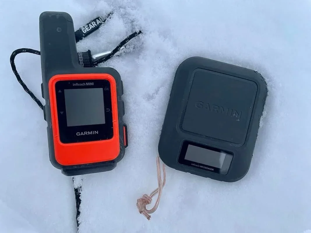
Our top choice: The Garmin inReach Mini 2 delivers the optimal combination of ultra-compact design, reliable global satellite coverage, and comprehensive two-way communication capabilities, making it the best satellite messenger overall for backcountry adventurers seeking maximum safety assurance with minimal weight penalty.
I’ve spent four decades working as a photojournalist, with work appearing in various publications, including National Geographic, Outside, Life, and Rolling Stone magazines. Assignments and photo adventures have taken me to nearly every hardscrabble place in the West and beyond. I’ve caught Dengue fever in the headwaters of the Amazon, suffered a touch of cerebral edema on Kilimanjaro, and rowed the Colorado River in the Grand Canyon twice.
That experience led to a years-long effort to understand everything I could about satellite messenger and emergency devices. This guide presents my findings on the top-performing satellite messengers and personal locator beacons that provide essential emergency communication capabilities for outdoor enthusiasts venturing beyond cellular coverage.
We create reader-supported, objective gear reviews independently selected by our editors. This story may contain affiliate links, which help fund our website. When you click on the links to purchase gear, we may get a commission — without costing you an extra cent. Thank you for supporting our work and mission of outdoor coverage for every body! Learn more.
Comparison Table
| DEVICE | TREELINE AWARD | MSRP* | WEIGHT (oz) | DIMENSIONS (in) | COVERAGE | WATER PROOF RATING | BATTERIES | BATTERY LIFE | SMART PHONE INTEGRATION? | MONTHLY SUBSCRIPTION REQUIRED? |
|---|---|---|---|---|---|---|---|---|---|---|
| Garmin inReach Mini 2 | Best overall Read why |
$400 | 3.5 | 3.9 x 2.0 x 1.0 | Global | IPX7 | Rechargeable lithium ion | Up to 5 days in 10-minute tracking mode | ||
| Garmin inReach Messenger | Best battery life Read why |
$300 | 4.0 | 3.1 x 2.5 x 0.9 | Global | IPX7 | Rechargeable lithium ion | Up to 28 days in 10-minute tracking mode | ||
| Garmin inReach Messenger Plus | Best upgrade Read why |
$400 | 4.1 | 3.1 x 2.5 x 0.9 | Global | IPX7 | Rechargeable lithium ion | Up to 600 hours or 25 days in low at 10-minute | ||
| Garmin GPSMAP 67i | Best with GPS navigation Read why |
$600 | 8.1 | 6.4 x 2.5 x 1.4 | Global | IPX7 | Rechargeable lithium ion | Up to 6.8 days in 10-minute tracking mode | ||
| Zoleo Satellite Communicator | Best budget Read why |
$150 | 5.3 | 3.6 x 2.6 x 1.1 | Global | IP68 | Rechargeable lithium ion | Average 8.3 days |
*Price reflects MSRP. See our Deals page for discounts on these items.
The Best Satellite Messengers and PLBs
Best overall two-way satellite messenger: Garmin inReach Mini 2
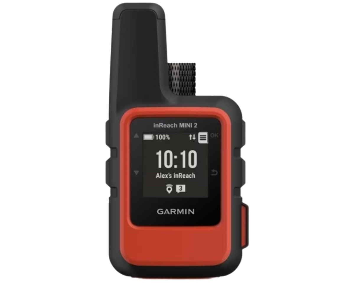
Weight: 3.5 ounces
Dimensions: 3.9 x 2.0 x 1.0 inches
Coverage: Global
Waterproof rating: IPX7
Battery life: Up to 5 days in 10-minute tracking mode
What we liked: lightest, most compact, battery life, two-way texting ability, pairs with GPS watches to trigger SOS
What we didn't like: expensive subscription plans
Weighing a scant 3.5 oz and measuring just 3.9” tall by 2” wide, the Garmin inReach Mini 2 is a full-featured satellite messenger that, though minuscule, does everything other satellite messengers do. Garmin uses the Iridium satellite network for pole-to-pole coverage with no gaps.
Size comes with a few caveats. Preset messages like “I’m OK” or “Stopping for the night” or custom pre-set messages that you’ve composed on a computer and synced to your device are easy. Anything beyond that requires syncing the Mini 2 to your phone in the field or using the virtual keyboard, which is cumbersome at best.
The Mini 2 pairs with your Apple or Android phone via Bluetooth wireless technology. You can then use your phone’s contact list, compose text messages or emails on a much larger keyboard, or more easily utilize the Mini's other features. Through Garmin’s free Messenger app, you can also access maps, aerial imagery, and US NOAA charts.
The Mini 2 is also compatible with other Garmin products, including their GPS watches. Treeline Review editors pair their inReach Mini 2 with their fenix 8 AMOLED GPS Watch, epix Pro (Gen 2), and Instinct 2 hiking watches, as well as the Forerunner 55 running watch. It also allows you to trigger an SOS message from the watch. Though we fortunately never have had to do it, this could be useful if a hiker, biker, or climber took a fall and were separated from their inReach device. We discuss triggering inReach devices from watches in our Best Hiking and Backpacking Watches story.
The Mini 2 runs on a rechargeable lithium battery, which can provide up to 5 days of use in 10-minute tracking mode. That's up from 50 hours of use in the previous model, the Mini 1. In close to 5,000 miles of hiking with the Mini 1 in 2019, including on the Arizona Trail and Pacific Crest Trail, we noticed a big difference in battery life between tracking modes. With the Mini 1, with a 30-minute tracking mode, we’ve been able to get two weeks between recharges for daily use of 12+ hours. With the Mini 2, our testers found that even after daily use of 12+ hours, we always reach town with the ability to recharge before the battery goes.
The Mini 2 does not have a built-in compass or barometer; it uses GPS for all of these readings.
You can read more in our in-depth review of the Garmin inReach Mini 2.
Note: Garmin has since released the inReach Mini 3 Plus—an upgrade to the inReach Mini 2. The Mini 2 is still available and a great deal. Learn more in our in-depth review of the Garmin inReach Mini 3 Plus.
Compare Prices of the Garmin inReach Mini 2
Satellite messenger with best battery life: Garmin inReach Messenger

Weight: 4.0 ounces
Dimensions: 3.1 x 2.5 x 0.9 inches
Coverage: Global
Waterproof rating: IPX7
Battery life: Up to 28 days in 10-minute tracking mode
What we liked: incredible battery life
What we didn't like: expensive plans
The Garmin inReach Messenger is a compact satellite communicator that fills a crucial gap in Garmin's device lineup. It offers essential features like SOS capability, two-way messaging, and email functionality while omitting advanced mapping and navigation tools found in pricier models. This streamlined approach makes it more affordable and user-friendly. We’d argue that most people don’t use the navigation features of these devices anyway, so they won’t even miss it (ourselves included).
The standout feature of the inReach Messenger is its incredible battery life. Garmin claims it can last up to 28 days in 10-minute tracking mode with a clear view of the sky. In real-world testing, it doesn’t last this long, but we’ve never come close to depleting the battery — even on multi-month thru hikes. It can also serve as a power bank to charge smartphones in emergencies, addressing a common issue in rescue situations.
We have also reviewed the Garmin inReach Messenger Plus.
View the Garmin Messenger
The inReach Messenger seamlessly switches between cellular and Iridium satellite networks, ensuring consistent communication. Users can send SOS alerts, share GPS coordinates, and exchange messages or emails regardless of location.
In order to send and receive custom messages, you have to pair it with your smartphone and use Garmin’s Messenger app. However, you can still send pre-programmed texts (such as “I’m OK”) and SOS messages without a phone. Additional features include route tracking, location sharing, and weather forecasts.
We spent a year extensively testing the Messenger in Colorado's mountainous terrain as well as multiple thru-hikes in Arizona and New Mexico. You can read our in-depth review of the Messenger here.
Best upgrade satellite messenger: Garmin inReach Messenger Plus

Weight: 4.1 ounces
Dimensions: 3.1 x 2.5 x 0.9 inches
Coverage: Global
Waterproof rating: IPX7
Battery life: Up to 600 hours or 25 days in low-power messaging mode with 10-minute intervals
What we liked: incredible battery life
What we didn't like: expensive plans
Garmin’s inReach Messenger Plus is one of the most innovative SOS and GPS capable satellite communicators available today. For the first time, a shirt-pocket-sized, 4oz, GPS device can send photos, 30-second-long voice messages and 1,600-character texts from anywhere in the world. 🤯
To accomplish this, Messenger Plus utilizes an upgraded form of satellite connection, the Garmin Iridium Certus network and the Iridium Messaging Transport (IMT) system. This is the same Iridium satellite network Garmin has always used for inReach and GPS devices, but with a significant boost in satellite connectivity and communication ability that required significant software and hardware upgrades, one being a more sensitive antenna. Basically Certus and IMT allows bigger, better, faster everything.
For more information, see our in-depth review of the Garmin inReach Messenger Plus.
Compare Prices of the Garmin inReach Messenger Plus
As a standalone device Messenger Plus can track a trip, share location/s, check the weather, send preset messages, send (and receive) messages, and send an SOS.
To fully utilize the Plus’s functions requires pairing with a cellphone and using the free Garmin Explore and Messenger apps. With the Explore app, Messenger Plus has the ability to function as a GPS and do basic navigation. The Plus can use maps, download custom maps (all onto a cellphone), create a visible track, set a course, place waymarks, and do a trackback. With the Messenger app, the Plus can send and receive messages (preset and custom), with the ability to create 1,600-character texts. Messenger can send photos and do a 30-minute long voice message.
All these upgrades from Messenger do come at a significant cost increase. Whereas the original Messenger 1.0 can be purchased for $250, Messenger Plus costs nearly twice that.
Best Satellite Messenger with GPS Navigation: Garmin GPSMAP 67i
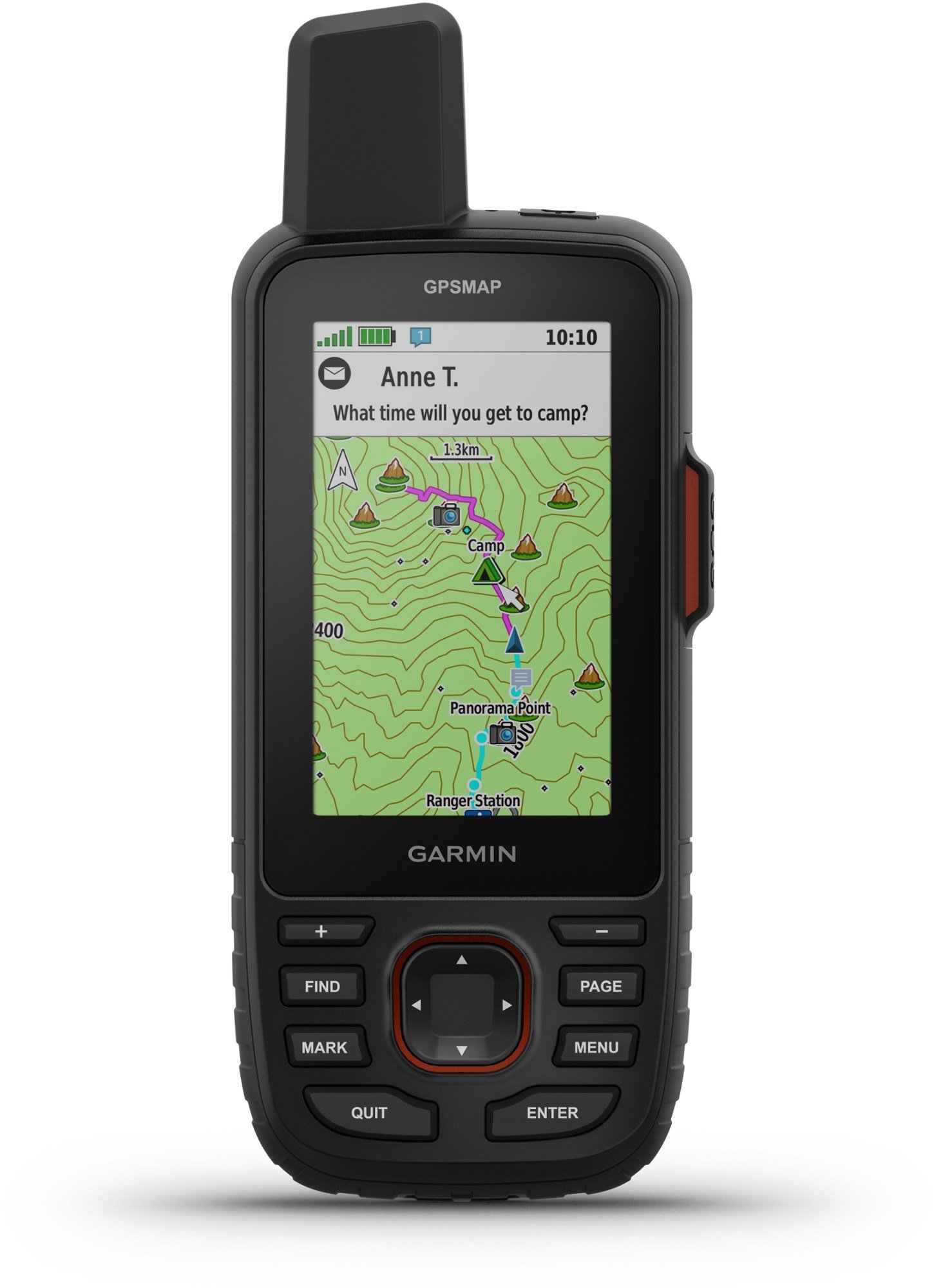
Weight: 8.1 ounces
Dimensions: 6.4 x 2.5 x 1.4 inches
Coverage: Global
Waterproof rating: IPX7
Battery life: Up to 6.8 days in 10-minute tracking mode
What we liked: excellent navigation, accurate location, full satellite messaging capabilities
What we didn't like: expensive, heavy
The Garmin GPSMAP 67i is the best satellite communication device with GPS navigation we’ve tested. Unlike other communicators that need to be paired with a smartphone to enhance navigation, the 67i is capable of doing everything in one self-contained unit.
The 67i has a large, vibrant color display for viewing high-resolution preloaded and downloadable maps. Utilizing multi-band GNSS satellite technology, it provides swift and precise positioning within 6 feet. The 67i's capabilities include tracking, TracBack, line-of-sight navigation, and waypoint/course creation.
Additional features include trip sharing via the Garmin Explorer app, real-time weather updates, messaging with other users, email and text functionality, social media integration, and an interactive SOS feature. The device also incorporates an altimeter, barometer, and compass.
You can read our in-depth review of the GPSMAP 67i here.
Compare prices of the Garmin GPSMAP 67i
Built to military-grade standards, the 67i withstands harsh weather and can survive 30-minute submersion in 3 feet of water. Its internal lithium-ion battery offers up to 6.8 days of tracking in 10-minute tracking mode and fully charges in just 2 hours via USB-C.
The device even includes a small flashlight and access to wikiloc.com, a trail encyclopedia app with global trail information and a worldwide user community.
Note: A subscription is required to access all features of the Garmin GPSMAP 67i, including the crucial SOS function. With a subscription, users can utilize inReach features such as mapping, tracking, and weather forecasts, along with numerous other functions of this fully-featured satellite communicator.
Without a Garmin subscription, the 67i is limited to basic GPS navigation, mapping, and core functions.
Best budget satellite communicator: Zoleo

Weight: 5.3 ounces
Dimensions: 3.6 x 2.6 x 1.1 inches
Coverage: Global
Waterproof rating: IP68
Battery life: Average 8.3 days
What we liked: Fast charging time, no annual contracts
What we didn't like: Location sharing costs extra, suspending a plan costs money per month if you want to keep the same SMS number, micro USB charging, doesn’t have weather forecasts, battery life
Similar in functionality to the Garmin Messenger but $100 less, the Zoleo satellite communicator is our top choice in the budget category. However, you’ll want to compare the monthly plans carefully, as the cheapest Zoleo plan is $20/month (for 25 messages), compared with Garmin’s $15/month (for 10 messages), and the Zoleo plan does not include location sharing. If you want to add location sharing, the cheapest Zoleo monthly plan becomes $26/month. If you suspend your plan, Zoleo charges $4/month to retain your SMS number. Plus, you’re required to keep your subscription for a minimum of 90 days when you first activate it.
Compare prices of the Zoleo Satellite Communicator
So it is truly cheaper than the Garmin Messenger? They don’t make it easy to compare. You’ll need to do the math for your use-case scenario.
The Zoleo doesn't have weather forecast capabilities, which we really missed. In the backcountry, we use our Garmin inReach devices to get daily weather forecasts.
The battery charges fast — just 2 hours. However, we wish it used USB-C, rather than micro USB. With so many devices to charge, it’s so much easier if they all have the same cord, and most new devices use USB-C. In addition, the battery life is not nearly as good as the inReach Messenger.
Still, if you’re looking for minimal initial cash outlay, the Zoleo can’t be beat.
Best Personal Locator Beacon (PLB): ACR Electronics rescueME PLB1

Weight: 4.0 ounces
Dimensions: 3 x 2.1 x 1.3
Coverage: Global
Waterproof rating: To 15 meters
Battery life: 7-year shelf life with 24-hour operational life
What we liked: no subscription fee, good for 7 years (but only 1 rescue), waterproof to 50 feet, easy to use, activation issues right on the device housing
What we didn't like: only 1 rescue (but that is the nature of PLBs), no two-way communication
Weighing just 4 ounces and measuring 3 inches long by 2 inches wide, ACR Electronics describes its rescueME PLB1 as the world’s smallest PLB. Which indeed it is, but not by much. If you need the lightest weight, no-frills unit, this diminutive, PLB may be just what you’re looking for.
View the ACR Electronics rescueME PLB1
Like all PLBs, the rescueME PLB1 has just one function, to summon a rescue with an SOS button. PLBs, in general, offer no two-way communication, no navigational GPS or mapping capability, and no subscription plan for service. If you send a distress signal accidentally, you can’t cancel it like the two-way transmitters we describe in this story. You can’t communicate the severity and needs of your emergency, either.
PLBs must be registered in the United States with the National Oceanic and Atmospheric Administration (NOAA) after purchase. This registration is free of charge.
The rescueME PLB1 has a retractable antenna, a GPS receiver, 7-year battery life, high-intensity strobe light, and is waterproof to 15 meters (about 50 feet).
Once used, or after the battery lifetime limit has been reached, you’ll need to return the rescueME PLB1 to the manufacturer for battery replacement.
In case of emergency, the activation instructions are right on the device itself.
Other devices we tested
Spot X with Bluetooth
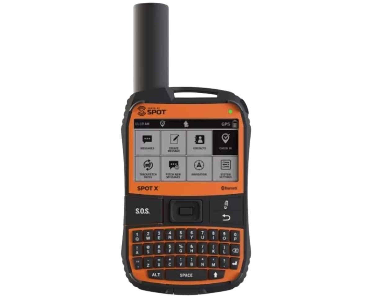
Weight: 7.0 ounces
Dimensions: 7.5 x 5.8 x 2
Coverage: Near Global
Waterproof rating: IPX7
Battery life: Up to 10 days
What we liked: keyboard is included so you don't have to rely on the phone, affordable subscription plans, two-way messaging, long battery life
What we didn't like: keyboard is difficult to use, navigation device is tricky to use with keyboard, slow to receive and send messages, customer service complaints
The Spot X is a fully contained two-way messenger unit that doesn’t use a phone link to make its features more user-friendly. Instead, Spot X has an illuminated QWERTY keyboard, similar to the old Blackberry devices. It uses the Globalstar satellite network with “near global” coverage, with gaps at some parts of the Pacific Ocean and some extreme northern and southern latitudes.
A huge benefit of the Spot X is that its battery life (rechargeable by USB) is 240 hours in continuous 10-minute tracking mode with a 100% clear view of the sky. That being said, some customer reviews show it is far less than reported, so while this hasn't been an issue for us, is something to keep in mind.
Although the Spot X can record trip statistics, has a digital compass, and has basic GPS navigation capability, we think it’s better to use your phone for navigation (we like the Gaia navigation app). It’s cumbersome on the Spot X, and not nearly as robust.
Anecdotally, we heard from users and saw an increase in negative customer reviews in 2022 regarding the speed of texts going in and out. Our own testing had similar results — text messages were faster to send and receive with Garmin devices versus Spot devices.
Still, the Spot X is a good option for folks who don’t want to rely on their phone or don’t want to carry a phone. In our research, its subscription fees are less expensive than Garmin's and offer more for your money (like more texts and more tracking). Like the other satellite messengers we considered, the Spot X requires a subscription to use (see our subscription price comparison chart for a summary of the Spot service plans).
Compare Prices of the Spot X with Bluetooth

Weight: 5.2 ounces
Dimensions: 4.5 x 2.0 x 1.5"
Coverage: Global
Waterproof rating: 5 meters for 1 hour
Battery life: 5 year shelf life, 28 hour operational life
The ACR ResQLink 400 PLB was our Best PLB last year, but we were concerned enough about some of the updates to remove it from our list. ACR moved the 400’s SOS button location to the front of the unit. This makes it too easy for the SOS to get activated from the PLB jostling in a backpack or pocket. There have been reports of SOS activation in a hiker’s back pocket. Therefore, at this time, we cannot recommend the ACR ResQLink 400 PLB and think that if you want a beacon, you’ll be better served by the RescueME described above.
Compare prices of the ACR ResQLink 400 PLB

A Kickstarter success in 2018, Somewear Labs is a relative newcomer to the satellite messenger space with their Somewear Global Hotspot. We tested the Hotspot side-by-side with the Garmin inReach Mini for 750 miles on the Oregon Desert Trail and 500 miles on the Mogollon Rim Trail.
Somewear is a waterproof, palm-sized device that weighs 4 oz that turns IOS and Android phones into hot spots, allowing satellite connectivity. It offers two-way communication, mapping, GPS navigation features, weather reports, and SOS capabilities. Somewear also offers tracking features, similar to a Garmin device.
Somewear offers global connectivity. You do not need your phone to send a distress signal from Somewear, but you cannot send texts from it without your phone. Like the Garmin Mini 2, it has two-way communication, so that once you activate the SOS signal you can communicate by text from your phone. Somewear offers a variety of subscription plans.
The Somewear Global Hotspot was significantly faster than the inReach Mini 2 in all ways tested. For example, in a side-by-side test we took, it took 40 seconds to get a weather report from the Hotspot; for the inReach Mini, it took 15 minutes.
The upside to Somewear is that almost all of us carry our phones everywhere anyway. Why not add a 4 oz piece of equipment that can turn them into satellite messengers and emergency devices? The downside? Even in protective cases, cell phones are fragile, and of course, you must keep your phone charged for Somewear to send an SOS.
View the Somewear Global Hotspot

The ACR Electronics Bivy Stick is a 3.4-oz device that turns iOS and Android phones into hotspots, allowing satellite connectivity just like the Garmin and Spot we reviewed above. At $200, it’s affordable.
The Bivy Stick requires a phone sync to send text messages, but it has a dedicated SOS button on the bottom so you can initiate a rescue even if your phone is out of power.
The Bivy Stick has monthly service plans but does not require an annual contract or charge activation fees. The service plans buy you credits for text messages, weather reports, location sharing, and tracking.
Our hesitation with the Bivy Stick system is the reliability. Anecdotally, several of our testers have had issues with messages not sending and the device itself not charging properly.
Compare prices of the ACR Electronics Bivy Stick

Why you should carry A satellite messenger device
Be prepared. That old Boy Scout adage. All of us going into the backcountry carry some variation of the ten essentials—map, compass, extra clothing and food, headlamp/flashlight, first aid kit, extra water, matches/fire starter, sunglasses/sunscreen, knife—but how many of us are prepared for a real emergency, the kind of life saving emergency that requires immediate action?
Bill Montgomery had hiked the Pioneer trail over and over again. His beloved dogs were buried in the forest along Cement Creek near Crested Butte, Colorado. On Christmas day, 2018, the temperatures hovered in the single digits. A deep early season snowfall forced Montgomery to post hole, plunging knee- and waist-deep into the snow. While sitting down to take off his powder-filled boots, he passed out. Upon gaining consciousness, he discovered his feet were frozen — “like blocks of ice.” Exposed for several hours to the snow and cold before being found by another hiker, Montgomery was dangerously hypothermic and severely frostbitten. The Crested Butte News reported that both legs would probably have to be amputated.
Otter Olshansky was a Triple Triple Crown hiker—he’d walked the 2,200-mile-long Appalachian Trail, the 2,600-mile-long Pacific Crest Trail, and the 3,100-mile-long Continental Divide Trail several times each. In November 2015, while walking the CDT in northern New Mexico, The Otter became stranded by a snowstorm. Trying desperately to survive, he sought shelter in a campground restroom, constructed snowshoes and skis out of scraps, and burned down a wooden storage shed hoping the smoke would draw attention. Eventually, The Otter succumbed to dehydration, starvation, and hypothermia. Another CDT hiker found his body the following spring.
How quickly and unexpectedly a person can find themselves in serious trouble, even on familiar trails, no matter how experienced they are. If Montgomery or Otter had been able to send out an SOS with a satellite messenger or personal locator beacon, the outcome would have been different. Press the SOS button on your handheld device, and within a matter of minutes, search and rescue will respond to your emergency no matter where or what it is.
But what exactly are satellite messengers and personal locator beacons (PLBs)? How are they different, how do they work, how much do they cost and which one should you take on your adventures? We dove into all your questions about how these systems work to determine what device will best serve you in your outdoor pursuits.
How we tested

We tested the Somewear (left) and Garmin inReach Mini 2 (right) side by side on the Oregon Desert Trail. Photo courtesy Mike Unger.
Here at Treeline Review, we’ve culled the SEND (Satellite Emergency Notification Device) field of more than 26 items down to the six best for your adventures. We’ve spent years testing these devices on thru hikes of the Oregon Desert Trail, Pacific Crest Trail, Continental Divide Trail, and more. We’ve also tested them backcountry skiing in the Colorado San Juan Mountains and bikepacking the White Rim Trail.
We do not consider a satellite phone or cell phone to be an emergency beacon. Even the lightest model satellite phone, the Iridium Extreme 9575, weighs a half-pound, costs over a thousand dollars (you can rent one for $50 a week), and requires a pricey $50 a month subscription plan that gives a user 10 minutes of talk or text time. One outgoing text burns one minute of airtime.
Cell phones work as long as you have land-based cell towers within range. What happens if an emergency doesn’t coincide with coverage? Some new advances in phone connectivity to satellite and land-based networks (Somewear Global Hotspot) may change this soon. But for now, we aren’t seriously recommending the cell phone-based systems that are just coming to market.
Our Testing Process
Years of real-world testing on long-distance trails and backcountry adventures
Testing Locations
- Oregon Desert Trail (750 miles)
- Mogollon Rim Trail (500 miles)
- Pacific Crest Trail thru-hikes
- Continental Divide Trail
- Colorado San Juan Mountains
- White Rim Trail bikepacking
What We Test
- Battery life & performance
- Message transmission speed
- Satellite coverage reliability
- Weight & size comparison
- Subscription cost analysis
- Durability & water resistance
What to look for in satellite messengers and personal locator beacons

Treeline Review tester Morgan "Storm" Dzak wears a Garmin Explorer on her pack during a difficult passage above the Gila River while hiking the Continental Divide Trail in New Mexico. Exposed to the sky on the back of her pack the Garmin helped Storm keep track of miles. Photo by Dean Krakel.
Choosing the right emergency communication device comes down to understanding your specific needs and how you'll actually use the device in the field. After testing dozens of units across thousands of backcountry miles, here are the key factors that matter most.
Coverage area
Not all satellite networks are created equal. Garmin devices use the Iridium satellite constellation, which provides truly global coverage including polar regions. Spot devices rely on the Globalstar network, which offers "near-global" coverage but has gaps in some parts of the Pacific Ocean and extreme northern and southern latitudes. For most North American adventures, either network will serve you well, but if you're planning expeditions to remote polar regions or crossing major oceans, Iridium's global coverage becomes critical.
Communication capabilities
This is where personal preference really comes into play. PLBs offer only one-way emergency signaling—press the SOS button and help is on the way, but you can't cancel the signal or communicate with rescuers about the nature of your emergency. Satellite messengers allow two-way communication, letting you send custom messages, cancel false alarms, and provide details about your situation to rescue teams.
Consider whether you want preset messages only (like "I'm OK" or "Stopping for the night") or the ability to compose custom texts. Some devices require smartphone pairing for custom messaging, while others have built-in keyboards. If you're someone who doesn't want to carry or rely on a phone in the backcountry, look for units with standalone messaging capabilities.
Weight and size
Every ounce matters when you're carrying everything on your back. The lightest units weigh around 3.5 ounces, while full-featured GPS communicators can tip the scales at over 8 ounces. Think about your typical trip length and pack weight tolerance. For ultralight backpacking or long-distance hiking, those extra ounces add up quickly. For car camping or shorter trips, a heavier unit with more features might be worth the trade-off.
Power and battery life
This breaks down into two categories: rechargeable devices and long-term battery units. PLBs typically use non-rechargeable batteries that last 5-7 years but require factory replacement when depleted. Satellite messengers use rechargeable batteries that need regular charging but offer weeks of use between charges.
If you're bad at remembering to charge devices or frequently take extended trips without resupply opportunities, a PLB's set-it-and-forget-it battery might appeal to you. But if you're already carrying other rechargeable devices and don't mind the charging routine, satellite messengers offer more flexibility.
Battery life varies dramatically based on usage. Tracking mode, message frequency, and weather conditions all affect power consumption. In our testing, devices that claim "28 days of battery life" often deliver far less in real-world conditions with regular use.
Because most satellite messengers pair with your phone for messaging, your battery strategy has to keep both alive. Our guide on how to keep your electronics charged on the trail walks through power bank sizing and a nightly charging routine that prioritizes safety devices first.
Subscription costs vs. One-time purchase
PLBs require no monthly fees—you buy the device, register it with NOAA, and you're set for years. Satellite messengers require ongoing subscription plans that can range from $15 to $65 per month depending on message allowances and features.
Do the math for your usage pattern. If you only venture into the backcountry a few times per year, paying $180+ annually for a subscription might feel excessive compared to a one-time PLB purchase. But if you're a frequent adventurer who values the communication and tracking features, the subscription cost becomes more justified.
Smartphone integration
![Backcountry guide Duncan Cheung says, "that’s another awesome hidden use case [of the Garmin inReach Mini]—geotagging photos from real cameras that don't have GPS built in.” Here, he uses the inReach Mini to geotag a photo of a lake in the Sierra.](https://images.squarespace-cdn.com/content/v1/5b4544e485ede17941bc95fc/1574126760468-M7BCGN51K7CWHT89N9NO/Using-inReach-Mini-to-geotag-photo-with-camera.jpg)
Backcountry guide Duncan Cheung says, "that’s another awesome hidden use case [of the Garmin inReach Mini]—geotagging photos from real cameras that don't have GPS built in.” Here, he uses the inReach Mini 2 to geotag a photo of a lake in the Sierra. Photo by Duncan Cheung.
Many modern satellite communicators are designed to work with your smartphone, using the phone's larger screen and keyboard for easier message composition and map viewing. This can make the devices more user-friendly, but it also creates a dependency on your phone's battery life and durability.
Consider your typical phone usage in the backcountry. If you frequently take photos, use navigation apps, or communicate with the outside world, your phone might not have enough juice to also handle satellite messenger duties. Some devices can function independently but offer enhanced features when paired with a phone—this hybrid approach often provides the best of both worlds.
Durability and environmental protection
Backcountry conditions are tough on gear. Look for devices with solid waterproof ratings (IPX7 or IP68) and proven durability. In our experience, the simpler the device, the more reliable it tends to be in harsh conditions. Complex touchscreens and multiple buttons create more opportunities for failure when exposed to rain, snow, and repeated impacts.
GPS accuracy and features
While all these devices include GPS capability for location reporting, they vary significantly in navigation features. Basic units provide location coordinates for rescue purposes but offer little in the way of mapping or route guidance. Full-featured GPS communicators include detailed topographic maps, waypoint creation, and turn-by-turn navigation.
Most serious backcountry travelers already carry dedicated GPS devices or smartphone apps for navigation, so the GPS features in emergency communicators often go unused. Focus on devices that excel at their primary mission—emergency communication—rather than trying to replace your existing navigation setup.
Ease of use in emergencies
When you're cold, scared, injured, or in a high-stress situation, complex menu systems and tiny buttons become major obstacles. The best emergency devices have clearly marked SOS buttons that work even when you're wearing gloves or your hands are shaking.
Look for devices with simple activation procedures clearly printed on the unit itself. You don't want to be fumbling through a manual when you need help immediately. In our experience, the most reliable emergency activation comes from dedicated SOS buttons rather than touchscreen interfaces or buried menu options.
What kind of emergency unit do you need? Personal locator beacon vs. satellite messenger
Handheld GPS Unit
There’s a difference between a handheld GPS unit and a PLB or Satellite Messenger. One serves as a map and compass or as way to record a track or waypoints. The other can send messages to the outside world that you need help.
If you just want a track or wapoints, read about the Garmin eTrex Solar Handheld GPS Unit Review. It’s not designed to be an SOS emergency replacement, but offers nearly endless battery life on a GPS unit.
Personal Locator Beacon
Personal Locator Beacons (PLBs) have one function: to send a distress signal. These small, lightweight, inexpensive, and nearly indestructible units offer no texting or two-way communication; they won’t function as a GPS, won’t track you with waypoints, give you a weather report, or link to social media. As far as keeping the people back home informed of your whereabouts and state of health, using a PLB is a “no news is good news” thing.

The clear plastic channel that the antenna fits into. Photo by Randy “Arrow” Godfrey.
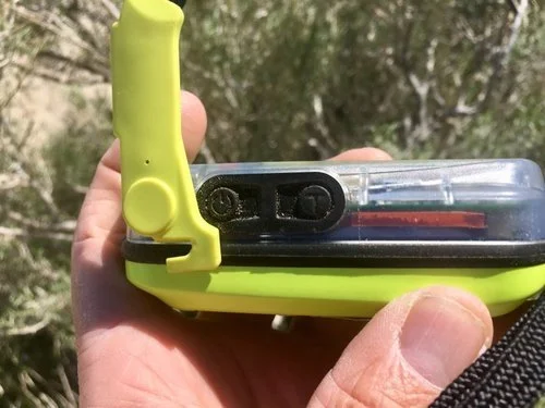
The antenna pops up and out. Photo by Randy “Arrow” Godfrey.
All the satellite messengers we considered come with a monthly subscription cost. However, there are no monthly subscription charges for using a personal locator beacon. Not having a subscription fee is one of the main advantages of a beacon. It’s one less thing to worry about if your credit card is stolen or your debit card draws from an empty bank account mid-adventure.
PLBs must be be registered with the National Oceanic and Atmospheric Administration’s (NOAA) beacon database. The registration is free.
When you send out a distress signal from a Personal Locator Beacon, NOAA receives your ping, along with the coordinates of your GPS location. NOAA then forwards your information to the United States Air Force Rescue Coordination Center. The US Air Force takes over organizing your rescue, responding, or contacting the nearest search and rescue organization, just like GEOS does for satellite messengers.
Having the Air Force in your back pocket may be a really handy thing if you’re poking around in foreign lands. It might be a lot better to have the Air Force responding to a personal crisis in Sudan than relying on local search and rescue if a country actually has such a thing. Some countries don’t.
Satellite messengers offer global emergency response just like PLBs. But before you travel, you should check each company’s coverage to be sure.

Keep the PLB in an easy-to-locate area that won’t easily get bumped or triggered during everyday use. Photo by Randy “Arrow” Godfrey.

After unhooking the end of the antenna, pull it out from under the plastic channel, straighten it completely then swing it straight up. Place the beacon flat on the ground (or rock ) facing skyward. Photo by Randy “Arrow” Godfrey.
Another advantage of PLBs is that batteries last for years (if not used for an emergency). This means you never have to remember to charge your device. But once the batteries are low (you don’t want to go into the woods with low battery on any unit), they have to be sent back to the factory for a checkup and battery replacement.
One reason you may prefer a satellite messenger over a PLB is that once a beacon sends a distress signal, it cannot be canceled. Once initiated, your PLB will bring you a rescue team, whether you meant to press that button or not. You also can’t communicate via PLB with rescuers to let them know the nature of your emergency.
Still, a beacon has some perks compared to more sophisticated satellite messengers. If you’re interested in a lightweight, inexpensive, emergency-only handheld device that provides a strong signal anywhere in the world (like all emergency devices it has to have an unobstructed view of the sky), has little upkeep, and no monthly fee, then a PLB may be what you’re looking for.

Morgan "Storm" Dzak checks messages on her Garmin Explorer satellite messenger during a break on the Continental Divide Trail near Leadville, Colorado. Photo by Dean Krakel.
Satellite Messengers
Satellite messengers differ from PLBs in that most models allow two-way non-emergency communication by text or email with nearly anyone you put into your contact information.
A satellite messenger allows you to cancel a distress signal and communicate with rescuers about the severity of your emergency situation. Think PLB with messaging.
Satellite messengers also give you the ability to turn a tracking application on and drop waypoints along your route. You can set the waypoints at intervals that span anywhere from a few minutes to a few hours. You can use these waypoints to help you navigate in the field or to retrace your route on a map later at home. You can share your tracking with anyone you send a link to, which can be done from your device in the field, allowing them to follow your route in almost real-time on their computers at home.
Guide Duncan Cheung shows his set-up for where he stores the Mini: in his snack food bag for the day (it’s the bright orange square in the clear bag on the right). Photo by Duncan Cheung.
To be honest, I’ve never had much luck with using my satellite messenger as a GPS. Newer models (mine is an older unit) are more GPS friendly. I have, however, used the tracking feature. I know my family appreciates me sharing the tracking link with them.
You don’t have to utilize the tracking feature to be rescued. You do, however, have to have the ability to hit that SOS button in an emergency. When you send out an SOS signal from your satellite messenger, it relays your coordinates to the search and rescue coordination center (in this case, GEOS) with near pinpoint accuracy.
Case in point: This winter, there was a fatal avalanche near where I live in Crested Butte, Colorado. Two very experienced backcountry skiers were training for the Grand Traverse ski race between Crested Butte and Aspen, a gnarly route that crosses the West Elk Mountains. They were carrying a satellite messenger as well as avalanche transceivers. With the tracking feature on, their families were able to follow their progress on a training exercise. All was well until their tracking waypoints stopped moving at Death Pass and never moved again. Something had gone terribly wrong. Search and rescue was contacted. From the coordinates given out at their last GPS fix, SAR knew that the pair were together at the bottom of the slide. Those coordinates got searchers close enough to pick up the signal from their avalanche beacon to locate them.

Wearing his Garmin inReach Mini, Kelly Garrod mounts his climbing skins for a backcountry ski trip on the Continental Divide near Tennessee Pass, Colorado. Photo by Dean Krakel
Unlike PLBs, satellite messenger batteries are rechargeable. This could be a drawback if you’re bad at remembering to charge your phone or if you already have many backcountry devices that need to be charged, like a camera, watch, and phone.
Satellite messengers work all over the world, though coverage varies depending on the satellite network. Like PLBs, messengers also need a clear view of the sky to get a GPS fix.
Unlike PLBs, messengers require a monthly subscription fee for use. Service plans for texting, sending pre-set messages, tracking, and receiving data (like weather reports) start at $14 a month depending on which unit you choose and how many features you anticipate using and how often. See our article on Garmin Subscription plan explainer to see more about costs and what is covered under different plans.
A perk of the two-way messenging? We describe in our How to Pace and Crew an Ultramarathon that races often take trail runners far from their crew to places without cell reception. A two-way messenger can allow your team mates to follow your progress in real time and give updates on health conditions of the racer.
EPIRB vs PLB
An Emergency Position Indicating Radio Beacon (EPIRB) is similar to a PLB in that it sends a distress signal upon activation. However, EPIRBs are registered to a specific vessel, while PLBs are registered to a specific person. Our review only covers PLBs.

The Mini next to a set of Subaru keys for size comparison. Photo courtesy Naomi Hudetz.
How do satellite messengers and PLBs work?
Satellite Network
All satellite messengers and PLBs utilize a satellite network to relay distress signals to search and rescue response centers. PLBs use the International Cospas-Sarsat satellite network. They do not need cell service to work. Spot uses its own GlobalStar satellites, which are "near-global" (missing the polar regions and some mid-ocean regions). Garmin relies on Iridium satellites, which are truly global.
Emergency Response Team Coordination
No matter what kind of messenger device you use or which satellite system your PLB uses, the message is received by a response team that coordinates the rescue. SOS alerts sent from satellite messengers are received by the GEOS International Emergency Response Coordination Center in Houston, Texas. The National Oceanic and Atmospheric Administration receives all PLB alerts, and they relay the messages to the U.S. Air Force Rescue Coordination Center at Tyndall Air Force Base in Florida.
Twenty-four hours a day, seven days a week, teams monitor incoming distress signals spanning the globe. These teams of emergency responders bring up your coordinates on mapping software. They call your emergency contacts for information about what you’re doing, your experience, age, medical history, itinerary, if you’re solo or in a group, and your food and gear situation. They will also contact you if your device has two-way texting or emailing capability.
Within minutes of receiving your alert, the search and rescue organization nearest you is contacted and given the known information about your emergency situation.
In most cases, an emergency responder, by whatever means necessary—be it a helicopter, airplane, horse, foot, four-wheel-drive, ORV, raft, kayak, boat, snowmobiles, snowcat, skis, snowshoes, police, sheriff’s deputies, military personal, national guard units, SAR volunteers and specially trained canines—is dispatched within an hour of getting the call.
A search and rescue effort can involve several organizations, dozens of people, hundreds of cumulative labor-hours, and a wide array of expensive technology. Just launching a search and rescue helicopter can cost over a thousand dollars an hour. Although each county and state has different search and rescue protocols, in New Mexico, for instance, the State Police organize a search. In Maine, the Warden Service is in charge. In both states, none of the expense is passed on to you.
Search and Rescue Expenses
“Search and rescue is all done by volunteers,” said Chris Boyer, executive director of the National Association for Search and Rescue. “There is no billing component. It’s free throughout the United States.”
The reason for this is because response teams don’t want people to avoid hitting the SOS button for fear of cost. “Delay,” said Boyer, “could cause someone serious harm.”
Although search and rescue is also free in Canada, in other countries, the cost could be passed on to you. Best to ask questions before you embark on a global trip. Likewise, if your rescue involves any kind of medical component—a flight for life, ambulance, or hospital—you’ll be footing the bill for those charges.
Nor will pushing the SOS be cost-free if you’ve intentionally or recklessly (lots of latitude in those definitions) endangered yourself and the rescue team, skied out of bounds at a resort, broken the law, or are a habitual SOS button pusher. In that case, charges are filed at the discretion of the rescuing organizations.

FAQ
-
PLBs (Personal Locator Beacons) only send one-way emergency SOS signals to government-run COSPAS-SARSAT satellites with no subscription fees, while satellite messengers provide two-way communication including texting, email, and tracking features through commercial networks like Iridium or Globalstar. PLBs are emergency-only devices, while satellite messengers offer daily communication and require monthly subscriptions starting around $15/month.
-
PLBs work truly worldwide through the international COSPAS-SARSAT satellite network with no coverage gaps. Satellite messenger coverage varies by device: Garmin inReach (Iridium network) provides global coverage, while SPOT devices (Globalstar network) have "near-global" coverage with gaps in polar regions and some ocean areas. Always check coverage maps for your specific destination before traveling.
-
Garmin inReach plans start at $14.95/month for basic service (10 messages) with annual contracts offering discounts. SPOT plans begin around $12/month for basic tracking. Unlimited plans range from $40-65/month depending on the device. Most providers charge activation fees ($20-35) and annual program fees for monthly plans. Compare total costs including device price, activation, and subscription fees for your specific usage needs.
-
With satellite messengers, yes - you can send a cancellation message through two-way communication to rescue coordinators before resources are deployed. With PLBs, no - once activated, they send a continuous signal for 24+ hours that cannot be cancelled, and rescue teams will respond regardless. This is why PLBs should only be used in true life-threatening emergencies when self-rescue is impossible.
-
PLB batteries last 5-7 years without use and provide 24+ hours of continuous operation when activated. Battery replacement must be done by authorized service centers. Satellite messenger batteries are rechargeable and last 2-28 days depending on usage mode - the Garmin inReach Messenger offers up to 28 days in tracking mode, while GPS-heavy devices like the GPSMAP 67i last 6-7 days.
-
For satellite messengers: Your location and SOS alert go to GEOS International Emergency Response Center in Houston, who contact local search and rescue while attempting two-way communication with you. For PLBs: Your signal goes to NOAA, then to the U.S. Air Force Rescue Coordination Center, who dispatch local SAR teams. Both systems operate 24/7 and typically initiate rescue response within an hour.
-
PLBs must be registered with NOAA's beacon database (free) before use - this provides emergency contacts and personal information to rescue teams. Satellite messengers require account setup with the manufacturer (Garmin, SPOT, etc.) and active subscription plans to function. Registration helps rescue teams understand who needs help and how to contact your emergency contacts.
-
Coverage depends on satellite visibility - both PLBs and satellite messengers need clear sky view to function effectively. PLBs have better signal penetration with 5-watt transmitters versus 1.6 watts for satellite messengers, potentially working better under dense canopy. In deep canyons or heavy forest cover, move to open areas or high ground to establish satellite connection before emergency situations arise.
-
Yes, modern satellite messengers provide emergency SOS capability equal to PLBs plus additional communication features. However, consider that satellite messengers require active subscriptions to function (including SOS), need regular charging, and may have slightly weaker signal strength. PLBs offer no-subscription emergency backup with longer battery life but lack communication features.
-
Satellite messengers are designed for text/email communication and emergency SOS, typically weighing 3-8 oz with extended battery life and costing $200-600 plus monthly subscriptions. Satellite phones provide voice calling but weigh around 8 oz, cost $1000+, require expensive monthly plans ($50+ for minimal minutes), and have shorter battery life. Most outdoor enthusiasts choose satellite messengers for better portability and cost-effectiveness.
-
For regular backcountry users, yes - the peace of mind, family communication, and emergency backup justify $15-30/month costs. Casual users might prefer PLBs with no ongoing fees for emergency-only protection. Consider your usage: frequent adventurers benefit from messaging and tracking features, while occasional users may find PLB's one-time purchase more economical for emergency-only coverage.
-
Modern devices provide GPS accuracy within 10-30 feet under clear sky conditions. PLBs manufactured after 2017 include encoded GPS coordinates in their signals, narrowing search areas from 2-3 miles to under 100 meters compared to older models. Satellite messengers typically provide real-time location updates with similar accuracy, helping rescue teams navigate directly to your position rather than conducting area searches.
-
Yes, an emergency device user can purchase insurance to cover medical evacuations. GEOBlue offers GEOBlue Travel Safety insurance (starting at $18 per year) to cover those kinds of charges, as does Global Rescue and a few other companies.
Some personal and travel insurance policies cover backcountry medical emergency costs. Most do not. GEOS also offers global medical evacuation insurance, starting at $110 for 30 days or $175 for a year of coverage. Again, best to do a little research and read the fine print. An excellent place to start looking into the why and what of backcountry insurance coverage is Expedition Portal.
It’s important to note the incredible expense of air ambulance trips, even with insurance. This NPR story documents a backcountry rescue that cost more than $50,000.
-
False alarms triggered by satellite messengers and PLBs occasionally happen.
It happened to me. My rescue was initiated by a faulty screen lock and SOS switch on the inReach unit—design flaws that were corrected in newer models.
“Ten years ago, when (satellite messengers) came out, that first generation, we saw the vast majority of false alarms,” said Boyer. “There are two extremes on why we have false alarms. a) mechanical malfunction and B) stupidity.”
Boyer told the story of a skier in Colorado that received a PLB as a Christmas present and assumed it was an avalanche transceiver, turning it on every time he went into the backcountry. At the other extreme, a group of Boy Scouts hiking in the Grand Canyon called in a search and rescue team three separate times because they’d run out of water. People have hit the SOS button simply because they’re cold, sore, or low on food.
Author’s Expertise/why you should trust us

Working as a photojournalist specializing in the outdoors has taken me to numerous remote and sketchy locations. And yet, up until just a few years ago, I never carried any kind of personal emergency device on any of my backcountry trips. I liked being on my own in the wild, dependent upon and responsible for no one but myself. Out of touch, out of reach, off the grid.
When I began documenting the 3,100 mile long Continental Divide Trail in 2016, I caved in to my family and friends and bought an inReach satellite messenger. Along with the emergency SOS button, the inReach device has two-way texting capability, a GPS, and a tracking feature that allowed people to follow my explorations on their computer screens. I could also get a weather forecast.
For the five months we spent walking north from the Mexican border on the Continental Divide Trail in 2018, my hiking partner Morgan Dzak and I relied on our Garmins. She carried an inReach Explorer+ (now discontinued).
When we misplaced each other, our inReaches reunited us. After an intense lightning storm in Colorado’s San Juan Mountains, we used our inReach units to rendezvous with a friend who trucked us to lower ground. Morgan used her Garmin to stay in touch with family and friends. When the need arose, and cell coverage was non-existent, we used the Garmin to summon a much-needed mountain taxi.
While hiking solo on the CDT in Wyoming’s Wind River Range, I was “rescued” by a SAR team when I inadvertently pushed the SOS button on my inReach unit while sleeping with it under my head to keep the batteries warm. I knew nothing about being rescued until a helicopter was hovering above my camp. You can read that story initially published in the Colorado Sun, which won a Society of Professional Journalists Top of the Rockies award.
No emergency satellite messenger or beacon is fail-safe. There are simple tests that you can do to ensure that yours is working. See your owner’s manual or call the manufacturer’s customer service number to find out how. Ultimately your safety in the backcountry is your responsibility.
My accidental SOS sparked a great curiosity about satellite messengers. I wanted to find out more about them and what other emergency units are available. Since then, I’ve become somewhat evangelical about being able to self-rescue or rescue others, and I wanted to know which devices I’d recommend to my friends and acquaintances.
You can see all of Dean’s Treeline Review stories on his author page.