Prescott Circle Trail Guide
winter-friendly Backpacking and Bikepacking 60-mile loop around Prescott, Arizona
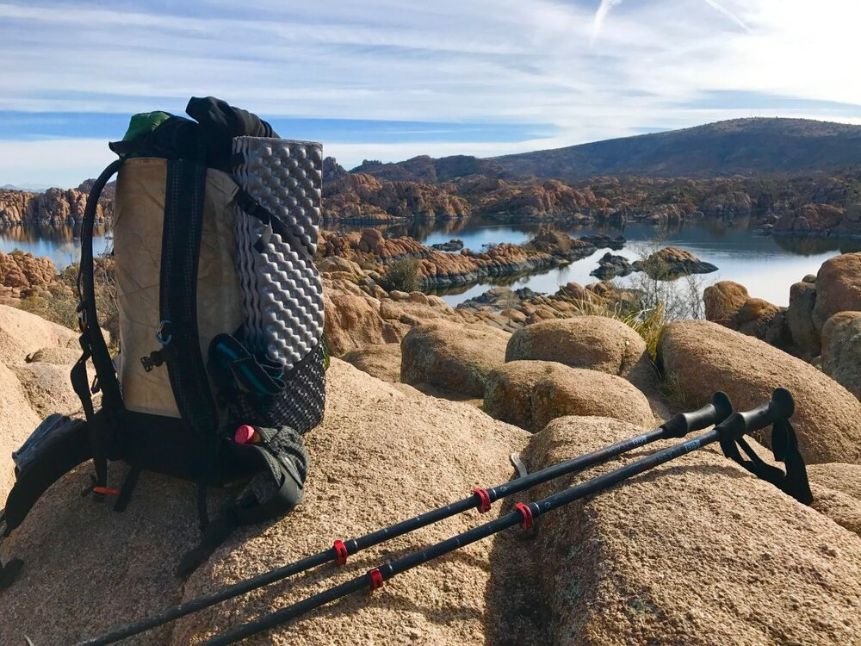
View of Watson Lake from the Prescott Circle Trail. Photo by Brandon Lampley.
Home > Backpacking Trips
Published February 5, 2024
The Prescott Circle Trail is a ~60-mile loop around the city of Prescott, Arizona. Snuggled in a shallow valley at the base of the Bradshaw Mountains, Prescott was the first territorial capital of Arizona and home to the Yavapai and Apache for millennia.
The ‘other PCT’ is open to all non-motorized use and is popular with hikers, runners, and mountain bikers alike. This winter-friendly trail skirts popular lakes and mountains that define the greater valley, with amazing views from a well-maintained and gently-graded hike and bike trail.
Distance: 56 miles
Days: 3–5
Elevation gain/loss: 6,650 feet
Best season: April–October
Permits: Required for campgrounds and some parking, none for hiking
Difficulty: Intermediate to Advanced


We create reader-supported, objective, independently-selected gear reviews. This story may contain affiliate links, which help fund our website. When you click on the links to purchase gear, we may get a commission — without costing you an extra cent. Thank you for supporting our work and mission of outdoor coverage for every body! Learn more.

View of Granite Mountain from Badger Mountain on the Prescott Circle Trail. Photo by Brandon Lampley.
What to know
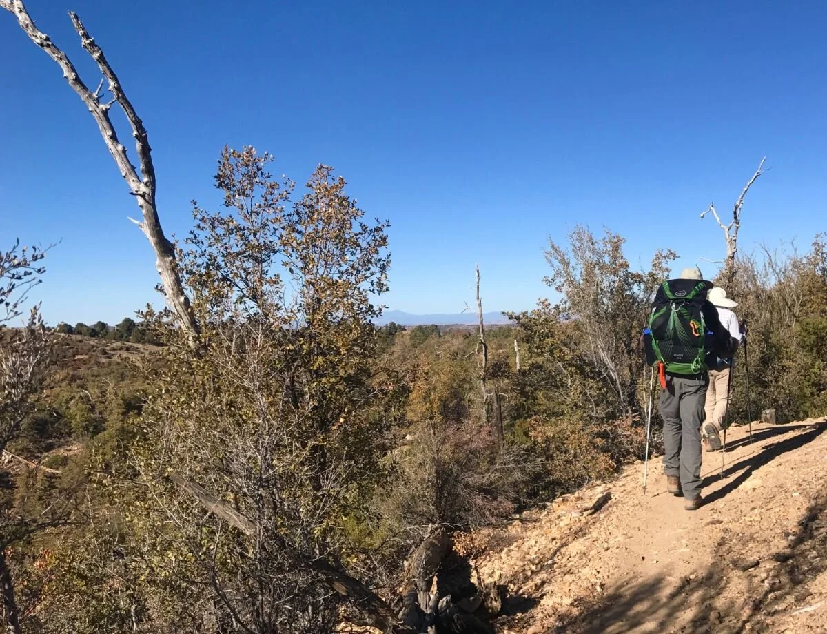
The author recently completed the Circle in a counterclockwise hike over three days, camping twice along the way in Forest Service campgrounds. While it's a great mini thru-hike for fit backpackers, the Circle is also popular with day hikers, trail runners, and mountain bikers. You might even meet some locals out on horseback along the way.
In this article, we’ll detail a three-day backpacking trip, suggestions for base camping and day hiking the whole loop over five days, as well as a few favorite loops that use the Circle.
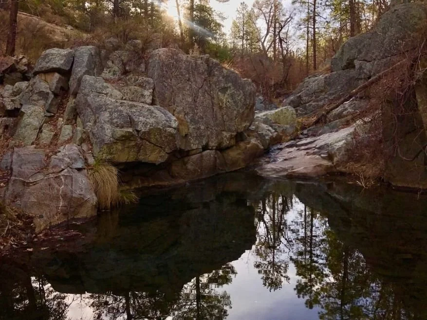
Pool at Banning Creek. Photo by Brandon Lampley.
Quick Facts
The Prescott Circle Trail was initiated in 1990 and completed in 2014.
Open to non-motorized travel, the trail is quieter than you may imagine for a trail so close to town.
Hikers, mountain bikers, and the occasional horseback rider share the trail. Learn more about right-of-way on shared trails.
About half the trail is maintained by the City of Prescott, and the other half by Prescott National Forest.
Camping in the Prescott Basin is restricted to campgrounds and designated dispersed campsites.
Highlights
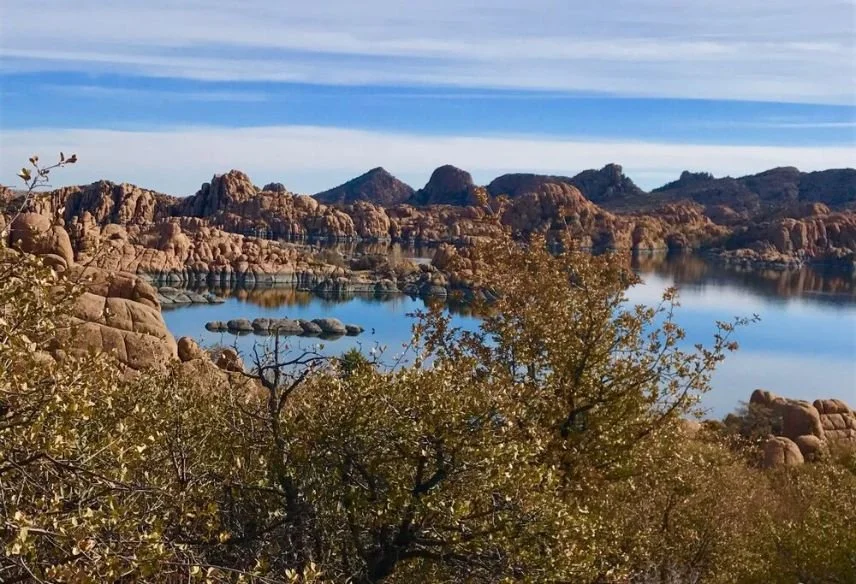
Exquisite views of the Granite Dells along the shore of Watson Lake.
Comfy camping and lofty views at the Yavapai Campground in Granite Basin.
The old growth Ponderosa Pine forest and cool stream along the tread from White Spar Campground up to Goldwater Lakes.
Expansive views from the slopes of Badger Mountain across the valley to Thumb Butte and Granite Mountain.
Challenges
Limited sources of drinking water.
Lack of shade is noticeable during the hot summer months.
You cannot camp wherever you want in the Prescott National Forest.

November through March can be a good hiking season for those with the skills to manage a little bit of snow and some water management. Photo by Brandon Lampley.
Best Season
Early April through the end of October. Water is turned off at campgrounds along the route from November 1 until March 31. The Yavapai and White Spar Campground are open year-round, while the Watson Lake Campground opens the second week in April.
November and March can have great hiking weather, but refilling drinking water is a challenge. Still, this can be a winter-friendly backpacking trip for those with adequate skills and experience carrying long hauls of water.
Mid-June through August temperatures are commonly in the low 90’s, so should be avoided.

The Prescott Circle Trail is marked with round signs. Photo by Brandon Lampley.
Navigation
The trail is very well signed along the way, and the overwhelming majority has good mobile phone signal. There are many trail junctions, so pay attention. Check your map and verify your location with the trail signage. The various trail segments have their own trail numbers labeled on the City of Prescott Trails and Outdoor Recreation Map. All trail junctions have an additional Circle Trail logo on the signage.
Terrain
The majority of the trail tread is maintained as beginner to intermediate single-track mountain bike routes, making for a smooth walk without steep grades.
About half the route passes through a high desert chaparral ecosystem: alligator junipers, buckbrush, scrub oak, and mountain mahogany. The other half takes you under the canopy of mixed ponderosa pine forest.
Rather than climbing hills directly, the tread primarily contours with the mountain slopes.
Elevation Gain and Loss
With a gain and loss of 6,650 feet in 56 miles, the pathway is rarely flat, but never steep.

The author at a kisok for the Watson Woods on the Prescott Circle Trail. Photo by Brandon Lampley.
Recommended Itineraries
The close proximity to town and the popularity of recreation around Prescott pose some unique logistical opportunities and challenges for those hiking or riding the entire trail as a continuous backpacking trip or mountain biking trip. We recommend completing it as a loop hike as a thru-hike or bikepacking loop (see below) or breaking it into day hikes by base camping (see below).
Thru Hike or Intro Bikepacking
The author completed this trail as a 3-day backpacking trip. The Yavapai, White Spar, and Watson Lake Campgrounds are the only on-route camping options.
The placement of these campgrounds relative to the distance of the hiking trail turns this trip into a feasible 3-day, 2-night trip beginning at the Peavine Trailhead near Watson Lake. Camping is restricted to designated areas in the Prescott Basin, making a 2-night hike the best option.
The City of Prescott also publishes two recommended 2-day ride maps. However, neither option starts or ends at campgrounds. The Circle intersects the greater trail system in many spots, so riders can take on longer and more technical nearby trails if desired. See our Best Bikepacking Bikes guide for our recommended bicycles and How to Get Started Bikepacking for suggestions.
Below are two recommended itineraries:
3-Day, 2-Night Backpacking or Bikepacking Trip
This is the itinerary that I hiked. I also think it would work well for an intro bikepacking trip.
Day 1 Peavine Trailhead, Mile 0, to Yavapai Campground
16 miles and 1,700 ft elevation gain
Camping: Reserve a site or limited walk-in spots available.
Amenities: Water, pit toilets, and trash collection available.
Day 2 to White Spar Campground
20 miles and 2,300 ft elevation gain
Camping: Reserve a site or limited walk-in spots available.
Amenities: Water, pit toilets, and trash collection available.
Day 3 back to Peavine Trailhead
20 miles and 2,600 ft elevation gain
Camping: Watson Lake Campground is at Mile 1.
4-Day, 3-Night backpacking trip
Beginning and ending the thru hike halfway through Day 3 (outlined above) is another possibility, with your first night camping at Watson Lake Campground
Start this version by accessing the Circle via a side trail from the Turley Trail Parking Lot near Mile 47. Mileages for the 4-day option are 10, 16, 20, and 11 miles hiking counterclockwise.
Basecamping
We've discussed the details of a 3-day backpacking trip; while this is an enjoyable way to complete the Circle, it is not the most popular.
A few years ago, a group of the author’s friends hiked the entire loop over 5 days as day hikes, camping at the Watson Lake Campground for a week, and shuttling cars to each days’ start and endpoints. All trail access points are no more than a 20-minute drive from town, meaning Uber or Lyft rides could support a consecutive day hike style, as well.

The Prescott City Valley viewed from the Prescott Circle Trail. It’d be easy to basecamp in town and Uber or Lyft to a trailhead over multiple days. Photo by Brandon Lampley.
The Yavapai Campground up by Granite Basin is the most remote of the camping options. We’d recommend it for a week-long stay. Watson Lake Campground is the closest to town, while White Spar is adjacent to a busy (and often noisy) road on the edge of town. Three nights at Yavapai and three at White Spar would give you the option to shuttle to your starting trailhead each day, and hike back to camp.
For a luxury thru-hike, a hiker could even arrange to stay at an Air BnB or hotel in town each night with the use of Uber/Lyft. We found mobile phone service good along the overwhelming majority of the trail.
Side Trips aka Loops
If it better fits your timeframe, there are several loop trail hikes in the Circle trail system that are both scenic and appropriate for a half-day or full-day.

Take a side trip on the Watson Lake Loop. Photo by Brandon Lampley.
Watson Lake Loop
A 7-mile loop around Watson Lake, in the Storm Trails area, through the Granite Dells. The dells are a range of low Granite domes, reminiscent of Joshua Tree National Park just to the east of Prescott. Signage at Watson Lake details the Loop.
Goldwater Loop
Hike from White Spar Campground to Goldwater Lakes via the Circle and trails 330, 374, and 396. Roughly 9 miles. Mostly forested, with mature Ponderosa’s, a visit to upper Goldwater Lake, and a couple of small streams.
Granite Basin Loop
A loop of about 8 miles from Yavapai Campground around the Granite Basin area. Mostly forested, lake, and Granite Mountain views. Trails 347, 348, 352, 345, and 349.

The Yavapai Campground in Granite Basin is one of the few places along the Prescott Circle Trail that requires fees and potentially reservations. It comes with amenities like a firepit, grill, and picnic table. Photo by Brandon Lampley.
Permits and Regulations
A permit is not necessary to hike the trail, but camping, and sometimes parking, do require fees and potentially reservations for the campgrounds.
City of Prescott trailheads requires a day fee. As of 2024, fees were $3 per vehicle at a kiosk or you can purchase annual pass online. You can read more here.
As of 2024, some Prescott National Forest trailheads have a day-use fee or require a recreation pass. The Interagency Pass (National Park Pass) is accepted instead of the daily pass. Wednesdays are free.
There are first-come-first-served campsites available at the three campgrounds, but a reservation is preferred if your itinerary is certain. Yavapai Campground and White Spar Campground are managed by Prescott National Forest.
Yavapai Campground sites are first come, first serve through March. From April to October, they are reservable at $26 per night as of 2024. Three first come, first serve sites remain available each day in peak season. Campsites are available 6 months in advance. More details and how to get reservations are available here.
White Spar campgrounds are $18 per night and reservable year-round up to 6 months in advance. There are at least 3 first come, first serve sites available year-round.
The city’s Watson Lake Campground site can be reserved here (includes camp map and rules) and here (scroll down to reserve by campsite number). The campground is open the 1st weekend of April through the 1st weekend in October, only Thursday through Monday nights. As of 2024, it costs $20 per night. There are 19 reservable sites and 15 first come, first service sites.
Is the Prescott Circle Trail Dog-Friendly?
Yes, you may hike with your dog, but they must be kept on a leash at all times. Also, keep in mind that this is a dry climate with limited water so you and your dog should carry sufficient water. You may want to consider dog footwear to protect your dog from spiky desert plants. See our dog hiking gear list or guide to Best Dog Hiking Backpacks for more tips and what to bring for hiking and backpacking with a dog.
Regulations
Follow Leave No Trace Ethics at all times. Carry your trash to the next receptacle, usually only found at campgrounds. Be tidy and clean when camping.
Practice good trail etiquette. Hikers should yield to both bicycles and horses.
If nature calls while toilet facilities aren't available, bury your waste and pack out your TP to a trash bin.
Respect private property. The trail passes near homes and kids’s camps properties.
Camp only in designated areas in the Prescott Basin zone of the National Forest.

Backpackers with views of Tom Thumb Butte on the Prescott Circle Trail. Photo by Brandon Lampley.
Route Summary
This is a detailed summary of the loop starting from Peavine Trailhead. Below is a databook with the landmarks and water.
Mile 0 is the Peavine Trailhead, where you begin by walking through a riparian nature reserve to Watson Lake. At Mile 1, pass a bathroom with water and continue along the lakeshore through the disc golf course. Signage is good, and another bathroom with water is near the entrance station and Campground at Mile 2.
Continue around Willow Lake to the start of some nice single track through the Embry Riddle campus at Mile 5. These first 5 miles are in town, but the views of the Granite Dells and lakes are quite nice. After passing under Pioneer Parkway, 4 miles of single track follow the Legacy and Longview Trails with great views, but little shade through the chaparral brush.
Miles 12 and 13 are the only paved road walks along the Circle. Walk the shoulder of the highway briefly until you can turn West on Yampa Drive into the quiet Katahn neighborhood. You’ll be back on a nice trail in the forest soon, continuing up towards Granite Basin. There are some trail options, but the simplest exit to the Yavapai Campground is at Granite Basin Rd at the end of Mile 16.

Climb to Goldwater Lakes through beautiful open Ponderosa Pine forest. Photo by Brandon Lampley.
The Granite Basin area and the next several miles to Iron Springs Trailhead pass through mature ponderosa pine forest mixed with alligator juniper. Miles 19 - 21 pass through Spence Basin on an old railroad grade. Numerous trails branch off here, but the signage is excellent for staying on the Circle route. An old stone chimney and cattle pen are trailside along Willow Creek. At Mile 22, on trail signage directs you up to the White Rock Trailhead, while the brochure map details a shorter route. Either option leads across Thumb Butte Rd and then Miller Creek. Mile 24 hosts the only switchbacks along the trail. Good valley views abound through these miles.
The great views and forest continue to Mile 28 where you cross Aspen Creek. Keen map readers will notice a shortcut on a forest road in these miles. We recommend sticking to the designated trail, as the views are better and the signage continuous.
You've been gaining elevation steadily, and the high point of the trail comes in two miles, at Mile 30, near Wolverton Mountain. The view to the east across the quartz-topped White Spar Mountain is splendid, and keen eyes will pick out the Goldwater Lake dam beyond. These miles enter a decade-old burn scar, where the Ponderosa forest hasn't yet returned.
Miles 31 - 34 lead down through this chaparral to cross White Spar Road just south of White Spar Campground. Leaving the burn scar, Ponderosa pine forest returns. The climb up to Goldwater Lakes over the next few miles is some of the nicest forest walking along the route.

Old prospecting pits along the Prescott Circle Trail show signs of the history of the area. Photo by Brandon Lampley.
At Mile 35, old prospecting pits can be found trailside, reminding us of the local gold rush history. If you want to understand more about how geology and water can be read to find gold, see my How to get started Gold Prospecting guide.
A bit further, Banning Creek has a nice miniature waterfall and trailside pool, a good spot for a break. The Circle passes close to the Goldwater Lakes, and we recommend a short walk to the upper lake at Mile 38.
After crossing the Senator Highway, the trail contours hillside for many miles on a gradual descent. Along Miles 42-43, views of Prescott Valley and Mingus Mountain to the east dominate the vista. At one point, there is a great view back into Prescott through a saddle. Mile 46 as you contour toward Badger (aka “P”) Mountain has expansive views of everywhere you've hiked in the past days. (Badger Mountain is among the most distinctive of Prescott landmarks for the distinctive "P" towards the summit).
After passing below the “P,” several miles weave around and down to a neat gully at Mile 50. Large oaks and alligator juniper fill the dry creek gully. The tunnel under the highway ahead is reached at Mile 51. Four more miles of mostly contouring trail descend back to Peavine Trailhead, completing the Circle.
Prescott Circle Trail Databook
| Mile Number | Landmark |
|---|---|
| 0 | Peavine Trailhead |
| 1 | Watson Lake, bathroom with water |
| 2 | Bathroom with water, Campground |
| 5 | Embry Riddle Campus |
| 7 | Ball fields, water 1/4 mile off trail |
| 12 | Begin 2 mile roadwalk |
| 16 | Exit to Yavapai Campground via Granite Basin Rd, water |
| 19 | Begin 2-miles through Spence Basin on railroad grade |
| 20.5 | Willow Creek |
| 22 | Choose to take the White Rock Trailhead or other route to Miller Creek |
| 24 | Only Switchbacks of trail |
| 28 | Aspen Creek |
| 30 | near Wolverton Mountain, high point of trail |
| 34 | Cross White Spar road south of White Spar Campground, water |
| 35 | Old Prospecting pits |
| 35 | Banning Creek and waterfall |
| 38 | Banning Creek and Goldwater Lakes |
| 46 | Views |
| 50 | Dry Creek gully |
| 51 | Tunnel Under highway, restaurants 1/2 mile off trail |
| 55 | Peavine Trailhead |

A sign with map for the Watson Lake Loop extension of the Prescott Circle Trail. Photo by Brandon Lampley.
Maps and Guidebooks
Maps
While a decent digital map is available from the City of Prescott website, hikers will want to get their hands on the print map brochure, available at the Hike Hut in town, or at several trailside kiosks at Watson Lake Park.
The detail on the print map is great, and it covers all the adjacent trails. Alas, it's not durable, so consider grabbing two: one to keep at hand, and one folded away in a Ziploc bag as a backup.
See the City of Prescott’s Prescott Circle Trail Map and Guide and the Prescott National Forest US Forest Service Map and Guide for the Prescott Circle Trail.
Guidebooks
A very detailed guidebook by Nigel Reynolds, Guide to the Prescott Circle Trail, is available locally.
Unfortunately, it’s not available online, so if you want the guidebook, pick one up before your trip and support a local business along the way.
This guide can be purchased for $10 at the following locations in downtown Prescott:
GAIA
The Gaia GPS smartphone app is one of our favorites for adventurers of all types. Gaia provides a variety of topographic and recreation maps and is useable online or off. Gaia helped me easily navigate to and from the campgrounds along the route.
Avenza
Avenza Maps users can download the Prescott Trails and Recreation Map with a QR code from the City website.
Getting There
By Plane
Flying into Phoenix (PHX) is your best bet. It’s about a 2-hour drive from Prescott, and likely the most affordable locale to rent a car. Phoenix is a major airport that often has affordable flights available. We’ve found flights as low as $50 on Kayak and Expedia. Once at the airport, you can rent a car or take one of the shuttles or buses to Prescott.
Car Rental
Because Phoenix is a major airport, you have options in car rental companies. You’ll find all the major ones (Enterprise, Hertz, Budget, etc.). Prices vary significantly depending on which company you go with, when, and what kind of car, so we’d recommend using a price comparison tool.
Shuttle Services
Alternatively, if you aren’t planning on doing Arizona sightseeing aside from the Prescott Circle Trail, it may be more affordable to take a shuttle.
Several shuttle companies make regular and on-demand trips from PHX to Prescott. Groome Transportation and Airport Shuttle of Phoenix both offer service to Prescott.
In and around town and to trailheads, Uber and Lyft are the best options.
Public Transit
A Greyhound bus line can get you from Phoenix to Prescott, as well.
By Car
Downtown Prescott is about 40 miles south of Flagstaff and 80 miles north of Phoenix, in north-central Arizona. Overnight parking is not generally allowed at the City trailheads. The Forest Service asks folks parking overnight at trailheads in the National Forest to leave a note visible on the dash explaining how long you'll be away. That said, we'd recommend leaving your car at your pre- or post-hike lodging in town (ask your hotel/Air BNB for permission), or at the parking area at the campground you're using as a basecamp.
Trailheads
According to the City of Prescott literature, 15 motor vehicle-accessible trailheads lie along the Circle. The route (as we describe it) has Mile 0 at the Peavine Trailhead, about a mile from Watson Lake.
Post-Trip Favorite Restaurants
For burger-hungry hikers, there’s both an In-n-Out Burger and Red Robin a half-mile off trail at Mile 51.

Cold water therapy can reduce swelling. Just be sure to soak 200 feet from where water is gathered for drinking. Photo by Brandon Lampley
Water Planning
For thru-hikers, understanding water availability is key. Given the quality of the water we found, we recommend a filter versus drops or tablets for the small streams. See our Best Water Filters and Purifiers guide for recommendations.
Caching water along the route may be a necessity during drier seasons unless you're willing to carry 4-6 liters from the Campgrounds.
Here are the reliable sources for a spring (April) hike:
Prescott Circle Trail Water Sources
| Mile Number | Water Source |
|---|---|
| 1 | Restroom Sink and Faucet |
| 2 | Restroom Sink and Faucet |
| 7 | Ball Fields, 1/4 mile off trail |
| 16 | Yavapai campground, 3/4 mile off trail |
| 20.5 | Willow Creek |
| 28 | Aspen Creek |
| 34 | White Spar Campground |
| 35 | Banning Creek |
| 38 | Banning Creek |
| 51 | Businesses, 1/2 mile off trail |
Food Storage
Bears are present but somewhat rare in the area, and there are no requirements for a bear canister or other storage.
Like most areas, mice, squirrels, and even raccoons are more of a threat to your food when camping. We recommend a food storage bag, like the Opsack. Keep a clean camp, contain the smells from your trash and food, and you shouldn't have any issues. For more information, see the Food Storage story or REI’s Bear Canister story.
Javelinas, also known as skunk pigs, are common in the forest and chaparral ecosystems and are active from dusk until dawn. Keep a tidy camp, as they are sometimes food curious.
Backpackers on Badger Mountain. Photo by Brandon Lampley.
BACKPACKING Gear List
Your standard 3-season backpacking kit will suffice for an April—October thru-hike, perhaps with the addition of additional sun protection.
Whether you’re into lightweight backpacking or more traditional backpacking, see our Backpacking Gear section and our Essential Backpacking Accessories story.
If you’re headed to the trail in the early spring or late fall, see our Shoulder Season Backpacking Gear article for suggestions on how to make a 3-season kit warmer.
BACKPACK
I packed my kit in a Hyperlite Mountain Gear Windrider 3400 for the hike. It's great for up to a 30-pound load, nearly waterproof, and has great outside pockets and lashing. Aside from a change in mesh, it’s nearly identical to the upgrade winner in our Best Backpacking Backpack story.
TENT
I hiked in late winter, with some wind and snow in the forecast, and chose the Black Diamond Firstlight tent for shelter. The Firstlight was one of the tents we considered in our Best 4-Season Tents guide. Hikers and backpackers attempting the Circle Trail in less snowy conditions will better be served by the recommendations in our Best Backpacking Tents.
SLEEPING BAG
The Enlightened Equipment Revelation 20 quilt served me well. A 20-degree bag is our recommendation for most backpackers. A backpacking quilt is a popular option for lightweight and ultralight hikers. Although it isn’t in our Best Sleeping Bags story (which is dedicated to full zip sleeping bags), the Enlightened Revelation is a popular choice for those who prefer quilts.
SLEEPING PAD
A sitting pad, such as the Therm-a-Rest Z Seat, for breaks is desirable due to the variety of prickly things. I carried a three-quarter length Therm-a-Rest Z Lite for sleeping and breaks. The Z-Rest is a former winner in our Best Backpacking Sleeping Pads story and is still a pad we recommend for its durability, weight, and price.
WATER FILTER
Water for about half the trail can be obtained from faucets. You’ll be collecting water from creeks for the rest. I used chemicals to treat the creek water but found the water so gross that I got a Sawyer Squeeze filter afterward. The Squeeze is our recommended filter in our Best Water Filters guide.

The author wore a sunshirt with a hood, brimmed hat, and sunglasses for this hike, which is sunny and exposed even in winter. Photo by Brandon Lampley
What to Wear
FOOTWEAR
With a smooth tread underfoot, this is a great hike for trail running shoes. I wore a pair of Saucony Excursion Trail (men’s and women’s), with a pair of Dirty Girl gaiters to keep the sand and twigs out. These trail shoes are inexpensive and get the job done.
For other models we recommend. our Best Men’s Trail Running Shoes guide or Best Women’s Trail Running Shoes guide.
If you’d feel more comfortable in boots, check out our Best Hiking Boots story or our Best Lightweight Hiking Boots story. Alternately, many hikers find a hiking shoe has the durability and stability of a boot with the lighter weight of a trail runner. See our Best Hiking Shoes guide for more suggestions.
CLOTHING
This trail is a good place to augment your normal backpacking clothing selection with some additional pieces geared towards sun protection. Half the trail is open chaparral, and the forests are open enough to provide little shade.
Prana Calder Sunshirt (now discontinued) — If it’s cool in the morning, a base layer is great for layering. The Calder has the benefit of providing sun protection and is a favorite in my Bicycle Touring Packing List for that reason. All base layers provide some sun protection. See our Best Baselayers guide or Best Sunshirts guide for other more traditional recommendations.
I'd normally hike in shorts, but chose long pants for this trail for extra sun protection.
UMBRELLA
A sun umbrella is also desirable for this trail given the lack of shade. I carried an umbrella by Montbell.

About the Author and Why You Should Trust Us
Brandon Lampley is Senior Technical editor at Treeline Review. He’s an all-around outdoor enthusiast who comes to Treeline Review from Outdoor Gear Lab, where he was Senior Editor.
Brandon has summited Denali and Ama Dablam and pioneered first ascents in the Indian and Chinese Himalaya.
His bigwall climbs include several El Cap routes in Yosemite.
He’s spent a month kayaking the Sea of Cortes, bike toured across the U.S. several times, and thru-hiked the Pacific Crest Trail and the Appalachian Trail.
For three years, Brandon lived and worked in Phortse, Nepal as the project director of the Khumbu Climbing Center where he worked alongside Nepali climbers to increase safety for high-altitude climbers and workers.
When he’s not on a long trip or traveling, Brandon lives in his van exploring the U.S. and has biked and climbed in 48 states and 20+ countries. Most recently, he can be found gold-panning in the mountains of North Carolina. He holds degrees in Environmental Science, Geology, and Psychology from Duke University. You can read all of Brandon’s Treeline Review stories on his author page.


