Bikepacking The Kokopelli Trail
143-mile desert bikepacking route that connects Fruita, Colorado and Moab, Utah
September 9th, 2023

The Kokopelli Trail is a 143-mile desert bikepacking route that connects Fruita, Colorado, in western Colorado and Moab, Utah.
Distance: 143 miles/ 230 kilometers
Days: 3-4
Elevation gain: 13,595 feet/ 4,144 meters
Elevation loss: 14,058 feet/ 4,285 meters
Unpaved: 85%
Singletrack: 15%
Best season: Spring/Fall
Permits: None
Difficulty: Hard
Related: Bikepacking the White Rim Trail
Read More: Bikepacking the Colorado Trail


We create reader-supported, objective, independently-selected gear reviews. This story may contain affiliate links, which help fund our website. When you click on the links to purchase gear, we may get a commission — without costing you an extra cent. Thank you for supporting our work and mission of outdoor coverage for every body! Learn more.

The Kokopelli Trail is a 143-mile desert bikepacking route that connects Fruita, Colorado, and Moab, Utah.
Quick Facts
A mix of dirt roads, desert Jeep tracks, and singletrack trails
Good fitness levels and intermediate mountain biking technical abilities required
The route is almost entirely on BLM (Bureau of Land Management) land with lots of great camping on public land
Caching water is almost a requirement to bikepack the Kokopelli Trail self-supported

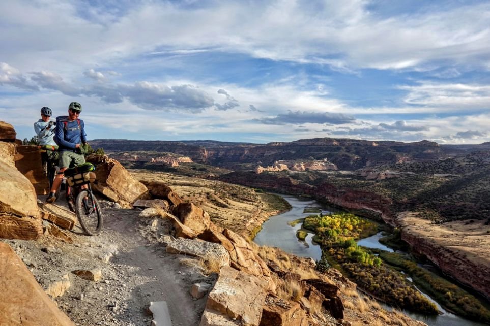
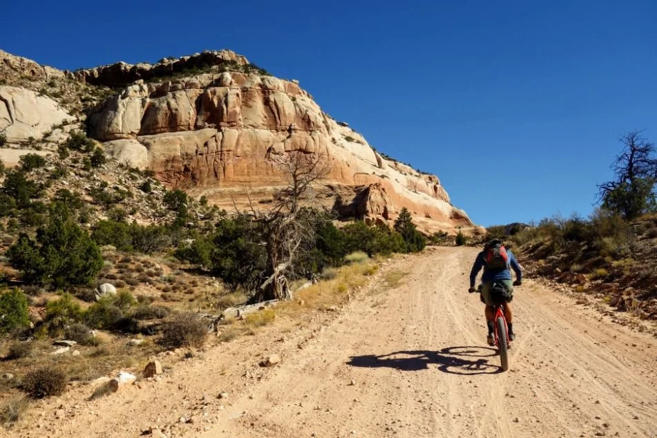
The Kokopelli trail connects singletrack, Jeep roads, and dirt roads following the Colorado River
Kokopelli Trail Background Info
The Kokopelli Trail is a 142-mile desert bikepacking route linking the mountain biking epicenters of Fruita, Colorado, and Moab, Utah. This route follows singletrack trails, Jeep roads, and dirt roads, mainly on Bureau of Land Management (BLM) land. It follows the Colorado River, and you’ll regularly get views of the river as it winds through the landscape below.
The Kokopelli Trail is not for beginner cyclists. There are long stretches of challenging desert riding, and those new to the sport will find it very challenging. The weather can be unpredictable, regularly swinging from blazingly hot to frost-and-ice-all-over-your-tent cold. If you can ride intermediate-level mountain bike terrain, the Kokopelli Trail will be a rewarding experience.
The Kokopelli is world-class bikepacking. It’s so good you’ll want to do it again once you’ve done it.

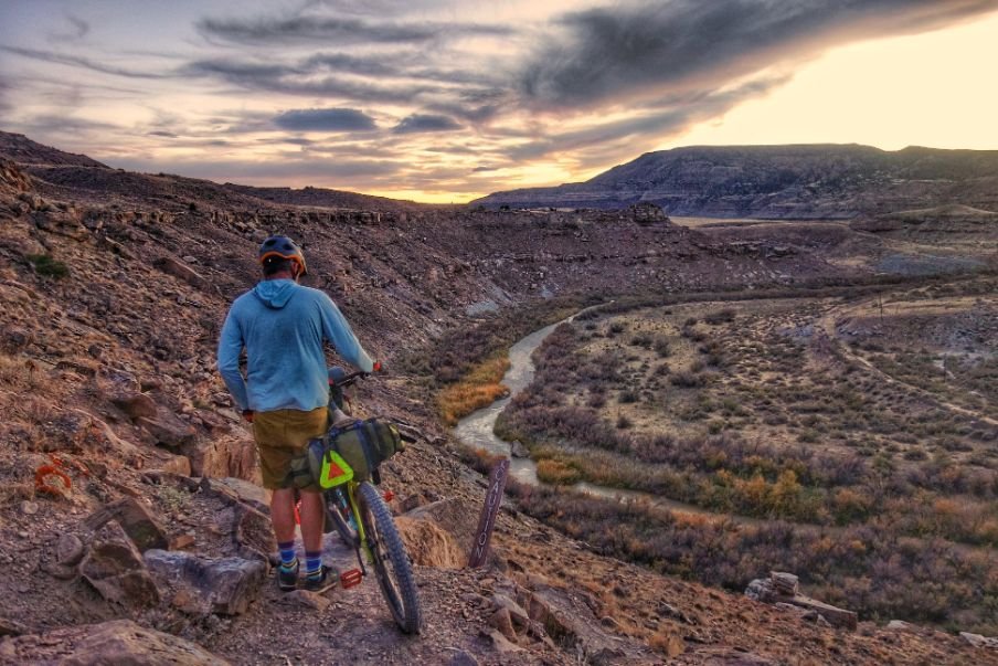
Bikepackers camping along the Kokopelli trail
Highlights
The singletrack section you’ll start on is some of the best mountain biking in the country
Descending out of the La Sal Mountain range into Moab is a particularly fun downhill
Camping in Fisher Valley
Yellow Jacket Canyon camping and riding
Challenges
Loose, sandy desert roads
Many of the dirt roads are impassable after heavy rains
Challenging hike-a-bike sections
Caching or carrying water, or both
Best Season
It’s best to ride the Kokopelli Trail in the Spring and Fall. You risk getting caught in a winter storm if you go early in spring or late in fall. A big storm can leave you stranded on unrideable dirt roads of sticky, peanut butter mud that will stop your wheels from turning.

The Kokopelli Trail is a difficult bikepacking trail. You should be in excellent physical shape and have previous bikepacking experience to attempt a self-supported bikepacking trip on this route.
Difficulty and Skills
The Kokopelli Trail is a difficult bikepacking trail. You should be in excellent physical shape and have previous bikepacking experience to attempt a self-supported bikepacking trip on this route.
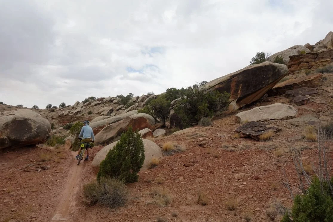
The riding is primarily non-technical dirt roads and Jeep double track, but it is about 15% singletrack. The Jeep trail and dirt roads can sometimes be very sandy, challenging, and slow-going. Some of the singletrack is unrideable, too. There are several hike-a-bike sections of this trail. One section requires a rider to lift your bike over car-sized boulders. Every time I reach this point of the trail, I wonder if I’ve taken a wrong turn, but then I check a map, realize I’m on the route and laugh at myself for choosing to do this.

The Kokopelli Trail is relatively well marked, but you still need strong navigation abilities. There are unmarked turns, and it’s not always easy to see the brown carsonite trail markers at junctions.
Navigation
The Kokopelli Trail is relatively well marked, but a mountain biker still needs strong navigation abilities. There are unmarked turns, and it’s not always easy to see the brown carsonite trail markers at junctions.
Technical Singletrack
The first 15 miles of the Kokopelli are technical singletrack. More technical singletrack sections are on the descent into Moab and scattered throughout the route. Most rideable parts require at most intermediate-level mountain biking abilities.
Elevation Gain/Elevation Loss
Over 143 miles, you climb about 14,000 feet/4,144 meters and descend about the same. There are many steep, exposed climbs throughout the route.
Permits
You don’t need any permits to bikepack the Kokopelli Trail. You can camp almost everywhere along the route, too.

The Kokopelli Trail starts outside Fruita, Colorado, on some of the best singletrack in the Mountain West.
Route summary for Bikepacking the Kokopelli Trail
The Kokopelli Trail starts outside Fruita, Colorado, on some of the best singletrack in the Mountain West. After riding through the Kokopelli Loops trail network, you’ll get a taste of your first hike-a-bike down to Salt Creek (which isn’t safe to drink).
After the first 20 miles of singletrack, you’ll ride about 30 miles of dirt roads through Rabbit Valley, Castle Rocks, and Coal Draw. Westwater Ranger Station is a short detour away at the T-junction after the short pavement section through Coal Draw. You might be able to get water from a spigot here, but don’t count on it. You can access the Colorado River from here, though.
From Westwater, you’ll ride more desert Jeep roads through a vast desert expanse with red rock formations in the distance. There will be small sections of optional singletrack along the way, but the jeep roads you’ll be riding through here are loose and sandy enough that you probably won’t want more of a challenge.
You’ll cross highway 128 and then ride through Yellow Jacket Canyon, a highlight of the Kokopelli. There is amazing camping here, awesome slick rock riding, and stunning Colorado Plateau rock formations. I’ve always dropped my bikepacking bags and ridden this section unloaded since it’s a quick ride along highway 128 to get to either end of the section.
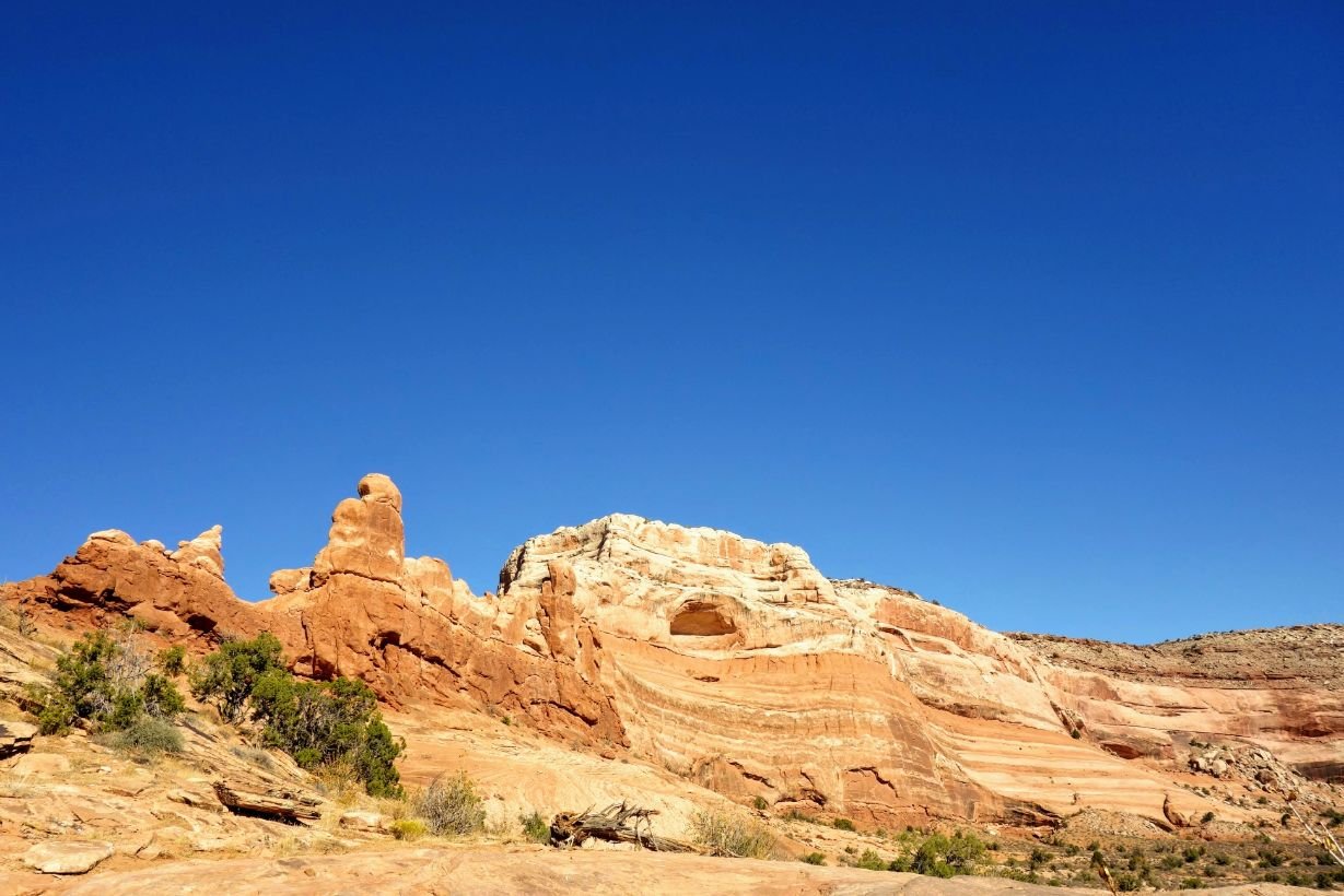
Rock formations including arches and windows are a highlight of bikepacking the Kokopelli Trail.
The southern end of Yellow Jacket Canyon crosses Highway 128 and passes Dewey Bridge before the most substantial climbing of the Kokopelli starts. Over the next 50 miles, you’ll do a lot of climbing, but the next ten miles will be the steepest. After a hot, exposed climb to Top of the World road, you’ll descend Rose Garden Hill and wonder how anyone could drive a Jeep over that.
Then you’ll be in Fisher Valley, where I’ve always cached water by the road. There is great camping in this area, too. From here, the climb into the La Sal Mountains starts in earnest. At the top, you’ll get great views of Moab and the surrounding landscape. Once you’re in the La Sals, you’ll probably find a stream or two to collect water from. I’ve even seen some water flowing in the fall around here.
The final climb will be on a paved road, but by this point, you’ll probably be ready for easier riding. As you get near the top of the final climb, the number of tourists you’ll see will make you feel like you’re already in Moab. But, there’s a still 17-mile 4,000-foot descent on dirt roads and singletrack trails between you and the end of the Kokopelli Trail. You’ll know you’ve completed the Kokopelli Trail when you hit the pavement; then, it’s time to celebrate.

Timing bikepacking the Kokopelli trail with the weather can be a challenge.
What I'd do differently next time
I have attempted the Kokpelli 3 times and completed it twice. The first time I attempted the trail in a group, we weren’t fully prepared and bailed. One group member attempted to ride the trail on a drop bar gravel bike with 2-inch tires. The other person in our group did not bring a storm-worthy shelter. We didn’t cache any water, either.
We were caught in a late March snowstorm and spent the day in a cave, watching the snow pile up. As the snow melted, those clay-heavy dirt roads became unrideable. After a day of waiting for the roads to dry, we bailed to the interstate, which was luckily still nearby. If it weren’t for that snowstorm after the first day, we would have found ourselves far out there, fruitlessly attempting to filter water from the silty Colorado River, slowed down immensely by the gravel bike that wasn’t enough bike for the terrain.
The following year I returned to the Kokopelli Trail more prepared. We cached water at a few road crossings, brought bikes with high-volume tires, and generally respected the challenges of the trail more. The second time was so good that I bikepacked the Kokopelli again.
I have bikepacked the Kokopelli on a fat bike with 5-inch tires and a “plus bike” with 3-inch tires. Riding the trail on a fat bike, I hardly noticed the extensive sections of sandy desert Jeep roads. Returning on 3-inch tires, I had a much more difficult time on those sandy sections.

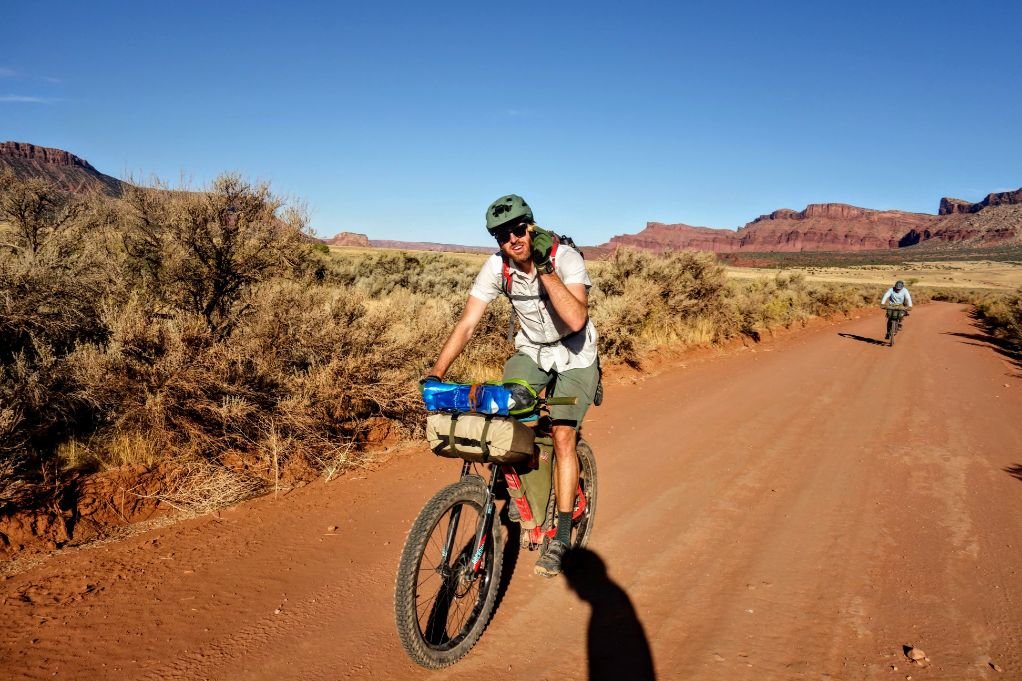
Most bikers ride the Kokopelli Trail soutbound.
Direction of Travel
Bikers most commonly ride the Kokopelli Trail southbound, starting at the Loma Trailhead and finishing in Moab. If you were to start in Moab and ride north, you would begin with a nearly 20-mile, 4,000-foot climb. Doesn’t this sound like a better way to end a trip as a descent?
Maps and Guidebooks
Ride With GPS
You can find the Kokopelli Trail on Ride With GPS
Maps
I’ve used the National Geographic Maps Moab North and Colorado National Monument for paper maps. The Kokopelli Trail is even marked on these maps.
Guidebooks
This Kokopelli Trail Guidebook from Bikerpelli is also helpful for planning your trip.
Other Apps
I think the Gaia GPS app is the most useful for backcountry navigation. Here’s a link to the Kokopelli Trail GPX track I’ve used every time.
Getting To The Trailhead
By Plane
The closest large airport to the Kokopelli Trail is the Salt Lake City International Airport. Moab has a small regional airport you can fly to from either Salt Lake City or Denver.
Grand Junction also has a regional airport and car rental options for caching water. From there, you’ll be closer to the start of the Kokopelli Trail.
By Car
The Loma Trailhead is west of Fruita, Colorado, along Interstate I-70. This trailhead is where the Kokopelli Trail starts and is even a location on Google maps now.
Bus and Shuttle Services
Moab Express provides shuttle service from Moab to the start of the Kokopelli Trail at Loma Trailhead.
Post Trip Favorite Restaurant
Moab Brewery is the only brewery in the town of Moab. As soon as you hit the pavement in Moab, you’ll see Milt’s Stop N Eat, where you can get a milkshake, fries, and a burger. Also, the Hot Tomato in Fruita has some of the best pizza I’ve ever eaten, and they have great beers on tap.
Regulations
Follow Leave No Trace Ethics, including camping and pooping far from water.
Group size must be limited to 12 people or less.
Resupply
There are no resupply options along the route. You’ll have to carry everything you need for the entirety of the trail. Fruita and Moab are full-service towns with grocery stores, restaurants, and cafes.

Water Planning
Water is a big challenge on the Kokopelli Trail. You’ll need to cache water on the Kokopelli. If you’re flying from out of town, I recommend you rent a car and spend a day caching water (or pay a guiding company to cache water for you, though I don’t know of any that specifically offer that service).
I recommend caching water at Rabbit Valley trailhead, near Dewey Bridge by the road along Highway 128, and Fisher Valley. You can get to Rabbit Valley and Dewey Bridge with a 2-wheel drive vehicle. I’ve made it on the dirt road to Fisher Valley in a Subaru, but a sedan wouldn't make it there. It will take about half a day to cache water and drive back to either end of the Kokopelli.
On my most recent Kokopelli bikepacking trip, my group drove from Denver in two vehicles. We met at the Loma Trailhead and split the caching duties between cars. One group dropped water at Rabbit Valley and Dewey Bridge, the other group drove the dirt road in an SUV to Fisher Valley and left a cache there.
We then met in Moab, loaded into one vehicle, and drove back to the Loma Trailhead. We used collapsible water jugs like these so we can strap them to our bikes and easily carry them out, too.
There is some water along the route, but not enough to forego caching water unless you can carry enough water for 2 days. Colorado River is too silty to filter, and some of the only other water sources along the route aren’t safe to drink due to the water’s arsenic levels. Don’t drink from Salt Creek or Onion Creek for this reason.
There is a reliable stream in Castle Valley, just before the road climbs into the La Sals. You might also be able to get water from a spigot at Westwater Ranger Station, but this source is not always operational. The last time I was there, I was told that the pipes were contaminated with E. Coli. The BLM’s webpage for the Westwater Station says explicitly, “do not depend upon this water source for your trip's water needs as the system is not always operational.”
There are also ways to filter silty water using alum. I’ve done this using collapsible water jugs, but it takes time and extra equipment.
Bears and Food Storage
Unless you’re camping in the La Sals, you likely won’t encounter bears on the Kokopelli Trail. But, store your food off the ground to prevent rodents from getting into it. I recommend using an Ursack as well, just in case.
See REI’s Food Storage story or REI’s Bear Canister story for more information on Bears and food storage.
Side Trips
Once you arrive in Moab, there are countless mountain bike trails to explore. I love the Bar M Trails just outside town for their flowy singletrack trail goodness.
Variations
I recommend riding the Western Rim Trail, a 6-mile trail parallel to the official Kokopelli route near Fruita. This only adds about 4 miles extra overall to your trip, but you’ll ride slick rock along the edge of a canyon rim overlooking the Colorado River instead of the less scenic route not along a cliff.
When coming into Moab, you can opt to ride the Porcupine Rim Trail to add a fun but technical singletrack descent into town. This variation would add approximately 14 miles to your trip. It would also add another 1000 jolts to your wrists and spine, as this trail is very bumpy. I don’t recommend riding Porcupine Rim without a full-suspension bike.
Bike Rentals
You can rent a full bikepacking setup from Bike Fiend in Moab.
Bike Repairs
The Bike Fiend or Chili Pepper Bike Shop are options for getting your bike repaired in Moab. You can also get your bike repaired at Over The Edge in Fruita.
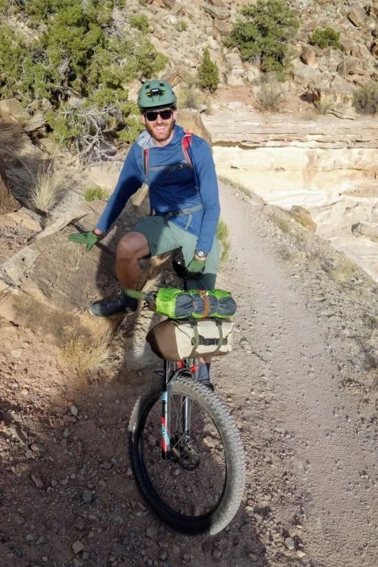
Fully packed bikepacking set up for the Kokopelli Trail
Gear List
For the Kokopelli Trail, I used a bikepacking kit. You can read more about what to carry on a bikepacking trip in our How to get Started Bikepacking guide. There’s a lot of overlap with our Bike Touring Packing List and Mountain Bike Gear and Accessories Checklist, too. This is especially true for the bike repair items.
Tent
I used a Tarptent Aeon Li tent for the Kokopelli Trail. I have experienced extremely high winds and snowstorms in the high desert regions of Colorado and Utah, and this tent always holds up well. For other backpacking tents we recommend, see our Best Backpacking Tents guide. If you think you’d prefer a tent designed specifically for bikepacking, check out our guide to Best Bikepacking Tents.
Sleeping Bag
I used a Cedar Ridge Outdoors Leconte 20* quilt, which appears to now no longer exist as a company. It’s a high-quality down quilt that has reliably kept me warm for 1000s of trail miles. If you're interested in a dedicated sleeping bag instead of a quilt, see our Best Backpacking Sleeping Bags guide.
Sleeping Pad
I used a Thermarest Neoair Xlite for this trail. I’ve used this inflatable pad for several years now. It’s reliable, keeps me warm, and Thermarest’s lifetime warranty is no joke. The Xlite is our overall winner in our Best Backpacking Sleeping Pads guide

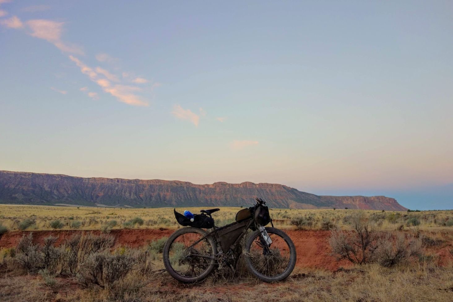
Our loaded bikepacking bike on the Kokopelli Trail
Bike
Surly Ogre with 27.5 x 3” tires and wheelset. The Ogre is one of our favorite bikepacking bikes in our Best Bikepacking Bikes guide
Bike Bags
SADDLE BAG
I used the Revelate Terrapin saddle bag. I write about this bag in my guide to Best Saddle Bags and Seat Packs.
HANDLEBAR BAG
I used a MYOG clone of the Swift Industries Zeitgeist. See our guide to Best Handlebar Bags for more recommendations.
FRAME BAG
I used a custom MYOG frame bag. You can read about the best non-custom, mass-market frame bags out there. These off-the shelf frame packs are more readily available than custom frame bags.

Our tent set up for bike camping on the Kokopelli Trail
Cooking System
MSR Pocket Rocket 2 stove, which is the overall winner in our Best Backpacking Stoves guide
Toaks 750 mL pot, which is the overall winner in our Best Backpacking Cookpot guide
Water Purification
Sawyer Squeeze, which is featured in our Best Water Filters and Purifiers guide.

An epic view point along the Kokopelli Trail
Clothing
Bedrock Cairns, which is the overall winner in our Best Hiking Sandals gear review.
Fingerless bike gloves. For more recommendations, see our Best Mountain Bike Gloves guide.
Specialized Tactic bike helmet. For more recommendations, see our Best Mountain Bike Helmet guide.
Generic padded bike shorts
Sleeveless wool t-shirt
Patagonia Women’s Nylon Capri Pants cut into shorts (discontinued)
Enlightened Equipment Torrid puffy jacket. For more recommendations of puffy jackets, see our Best Down Jackets or Best Synthetic Jacket guides.
MYOG Polartec Alpha Direct hoody
Generic tights
Enlightened Equipment Torrid booties. See our Best Camp Shoes guide for more recommendations on camp shoes we like.
Rain Gear
I brought an Ultimate Direction Ultra Rain Jacket for this trip. See our gear review of the Best Lightweight Rain Jackets for other recommendations.
Bike Lights
The Rando is a favorite in our Touring Bike Gear List. Our Best Mountain Bike Lights guide also covers other mountain bike-specific lights.
Headlamp
Petzl Bindi, which is a favorite of other Treeline Review writers and featured in our Backpacking Guide to the South Dakota Centennial Trail. We cover other lighting options in our Best Headlamps guide.
Bike Repair Kit
2 spare 27.5” tubes
Lezyne Hand Pump, which is featured in my guide to Best Bike Tire Pumps
Zip ties
Gorilla Tape
First Aid Kit
4 squares of gauze
Antibiotic ointment
Alcohol wipes
2 large square adhesive bandages
Ibuprofen
Sun Protection
Sunglasses
Trucker hat
You can read more about sun protection items we like in our Best Sunscreen for your Body or Best Face Sunscreen guide or on our Sun Protection page.

about the author
Sam Schild is a thru-hiker, cyclist, and mountain athlete based in Colorado. He has thru-hiked the PCT, CDT, Grand Enchantment Trail, and the Colorado Trail twice.
He has biked and bikepacked over 50,000 miles in the last decade, completing the Colorado Trail by bike, the Kokopelli Trail twice, a 7,000-mile cross-country bike tour, tons of other bikepacking in the American Southwest, and bike commuting everywhere he can. He has an MFA in Creative Writing from Temple University, and before becoming a freelance outdoor writer was an academic, teacher of writing, high school teacher, and a bike mechanic. When he’s not thru-hiking or bikepacking, you might find him running long distances on trails closer to home.
You can read more by Sam on his website samschild.com or on his author page.


