Backpacking the Colorado Collegiate Loop
160-mile loop of the Colorado Trail and Continental Divide Trail joining Collegiate East and Collegiate West

June 21st, 2026
Home > Trip Reports > Thru Hikes for Working People
Distance: 161 miles
Days: 10-16 for most folks
Elevation gain/loss: 35,560 feet
Best season: mid-July through mid-September
Permits: none
Difficulty: Intermediate to advanced
The 161-mile Collegiate Loop lies in the central Colorado Rocky Mountains. This spectacular backpacking route circumambulates the Collegiate Peaks section of the Sawatch Range above the trail towns of Buena Vista and Salida.
The loop is formed by using the miles of trail tread on the Continental Divide National Scenic Trail to complement the traditional route of the Colorado Trail east of the divide. Hot Springs, on-trail resupply, and a combination of forested river valleys and above treeline tundra make this one of Colorado’s most popular and desired two-week backpacking goals.
Read more of our trip reports here.
We create reader-supported, objective, independently-selected gear reviews. This story may contain affiliate links, which help fund our website. When you click on the links to purchase gear, we may get a commission, without costing you an extra cent. Thank you for supporting our work and mission of outdoor coverage for every body! Learn more.
Highlights
You’ll spend entire days hiking above 11,000 feet on the Continental Divide with some of the best views you’ll find on any long distance trail.
Summer wildflowers and colorful sunsets make photography exquisite.
There are abundant water sources that minimize the water weight carried.
You could spend a zero day at Mt Princeton Hot Springs Resort and Restaurant.
There are very nice trail towns nearby for you to acclimatize, rest, and recover.
There’s convenient resupply near the trail at Monarch Crest Store, Twin Lake General Store, and Princeton Hot Springs General Store.
You’ll likely cross paths with a range of adventurers (CDT and CT thru-hikers, other Loopers, and bikepackers on the Colorado Trail bikepacking route.
Challenges
Start early to avoid afternoon lightning storms for sections above treeline.
Wildfire smoke is possible (an ever-increasing presence in Colorado in season).
There are a few steep descents that can be hard on the knees on the downhill and hard on the lungs and legs on the uphill.
There are a few places where the trail is routed on roads to avoid private property, so plan your camping accordingly.
The Monarch Crest area is popular with mountain bikers.
For those coming from lower elevations, the thin air at altitude can be a challenge.
GEAR LIST
Here is a quick list of some of the items I had with me on the Collegiate Loop. For more detail on my gear choices, skip below.
| COLLEGIATE LOOP GEAR | OUR PICK | OTHER OPTIONS |
|---|---|---|
| Gear | ||
| Tent | Black Diamond First Light 2P Tent | Best Backpacking Tents Best Ultralight Tents |
| Backpack | Hyperlite Mountain Gear Windrider 55 | Best Lightweight Backpacks |
| Sleeping bag | Enlightened Equipment Revelation 20 Quilt | Best Backpacking Quilts Best Backpacking Sleeping Bags |
| Sleeping pad | Therm-a-Rest NeoAir NXT Sleeping Pad | Best Sleeping Pads For Backpacking |

Early July versus Mid September in the aspen forests on the East slope of the Sawatch Range.
Best Season
The first week in July is considered the beginning of the season, as snow fields and a potentially tricky cornice or two linger on the Collegiate West side (such as Lake Ann Pass) and a north slope or two on the East.
Most consider August the perfect time to backpack here, as the snow has melted and wildflowers abound. Thunderstorms and monsoonal rain can be a nuisance in August, though.
I’m comfortable with a bit cooler nighttime temps and think mid to late September is perfect. Aspen and willow leaves are changing, the few freezing nights have banished mosquitos, and most of the summer hiking crowd has diminished.
That said, there can always be a rogue early season snowstorm, dropping up to 2 feet at elevation. The safest season for above-freezing nighttime temps is mid-July through the end of August, and this will also be the busiest season on the trail.

Navigation
The trail is signed very well in most locations along the Collegiate Peaks Loop. The Collegiate West portion has both CT and CDT placards. Excellent paper maps are available, the FarOut guides phone app is up-to-date with several recent trail reroutes. Overall, we consider the navigation straightforward.
Town and resupply access is quite accessible from the several paved road crossings. The trail does cross many more dirt Forest Service roads, some more traveled than others. We do not recommend using these for trail or town access as traffic is light.
Hiking apps like the Farout guide or the Colorado Trail Databook are up-to-date and easy to use.
Terrain
All but about ten miles of the Collegiate Peaks Loop follow very well maintained single track trail tread, with nearly all graded 10% or less. New trail construction has minimize the amount of time you spend crossing talus fields. There are still a few steep climbs and descents, such as the base of Hope Pass. If you don’t usually hike with trekking poles, we strongly recommend them for this route.
Altitude & Elevation Gain/Elevation Loss
The Collegiate Loop is a mountainous route at a very high elevation in the United States. You will spend most of the two weeks at 9,000 ft or higher and entire days above 11,000 ft. If you don’t live at elevation, please consider spending at least 3 days, if not an entire week, acclimating to the thinner Rocky Mountain air.
Buena Vista and Salida are great places to basecamp a few days before your hike and have delicious restaurants, hiker-friendly hostels, as well as gear stores and running stores to get your last-minute equipment.

Two backpackers near Chalk Creek on the Collegiate Loop.
Recommended Itineraries: where to start and in which direction?
Collegiate East vs. Collegiate West? Where should I start?
I’d recommend the Collegiate Peaks Loop in a counterclockwise direction no matter where you start and finish. In my opinion, the climbs and descents are more comfortable in this direction.
Weather can be unpredictable in Colorado. Check the forecast and be flexible about which direction you hike based on the current forecast. If you have several clear days in the forecast, start with Collegiate West (even though it is more difficult). Colorado summer weather can change quickly so take advantage of days without thunderstorms to get over the exposed sections.
The FarOut app starts at Twin Lakes Interlaken, but there are many other places to start and finish the Loop, including the Clear Creek Trailhead. For example, I'd enjoy starting and finishing at Mt Princeton Hotsprings, with a stay on each end.
Counter Clockwise from Twin Lakes Interlaken Trailhead
Counterclockwise is a good option if you are well acclimated to the altitude.
I had always planned to start from Twin Lakes. I did all my planning for a clockwise trip, first hiking the Collegiate East southwards. I’m comfortable carrying six days of food, and the on-trail Monarch Crest Store resupply is practically at the halfway point.
However, considering the stable high-pressure weather forecast the day before my start, I decided to tackle the Collegiate West first. Much more of the Collegiate West portion of the loop is above the treeline, and a forecast with minimal chance of winds and afternoon storms was appealing. It is a minor added inconvenience to hike in the opposite direction than I had planned, but it was worth taking advantage of the good weather forecast. The Farout Guide also demarcates the route starting at Twin Lakes and hiking counterclockwise (starting with Collegiate West first).

The Collegiate Loop is well-signed with directions for the Colorado Trail, Continental Divide Trail, and the loop.
Clockwise from Twin Lakes
Clockwise is a better option for those who need to acclimatize slowly. It also has more frequent resupply opportunities early on, so you don't need to carry as much weight as you are still building your "trail legs."
Hiking the Collegiate East first has several advantages. The trail on this section is mostly below the treeline and offers folks who have recently arrived at altitude more time to acclimate. You’ll likely cross the paved road to Buena Vista on Day 3, and it would be an easy hitchhike into town to resupply. Day 4 will likely see you at Mt Princeton Hotsprings. The small store here has limited food options, but the resort accepts and holds resupply packages for thru-hikers and has a great restaurant.
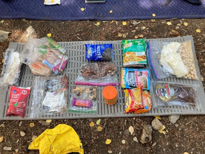
Collegiate Loop backpacking food for a leg of the trip.
Resupply
Whether you want to mail a resupply package or buy as you go, the options are pretty easy. While nearly every day presents an opportunity to hitchhike or shuttle into town, resupply options present themselves at reasonable intervals on the trail. These are places where you can send packages or get food.
| Miles | Resupply | How to get there |
|---|---|---|
| 3.5 | Twin Lakes General store (with food trucks) | On-trail |
| 32.8 | Buena Vista via CO Hwy 306 at Cottonwood Pass | Hitch from paved road |
| 65.1 | Butterfly House Hostel via Boss Lake Trailhead/ Forest Service Road 230 | Walk 2-miles on dirt-road or hitch |
| 78.4 | Monarch Crest Store or hitch to Salida via US Hwy 50 (Monarch Pass) | Store on trail or hitch to town |
| 92 | Salida via US Hwy 50 (Foose Creek Trailhead) | Hitch from paved road |
Permits
No advance permits are necessary for this trip. If you start on the Colorado Trail at a trailhead not part of the Collegiate Loop, know that some National Forest wilderness areas in the Collegiate Peaks wilderness may require a self-issue permit from a kiosk at the trailhead.
sample itinerary and Trip Report
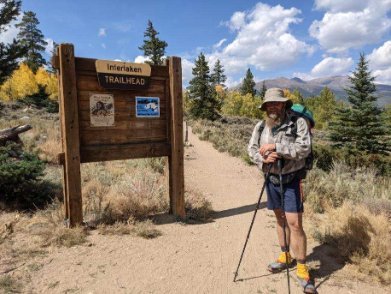
Starting the Loop at Interlaken Trailhead near Twin Lakes, and hiking Counterclockwise, is convenient for planning. Farout guides numbers the route’s mileage from this TH in this direction.
I started my Collegiate Loop thru hike in early afternoon from the Interlaken Trailhead at Twin Lakes, heading counter-clockwise starting on the Collegiate West side.
Before starting, I posted a food resupply box to the halfway point, Monarch Crest Store. I won't really mention water sources in my daily summaries. Even in September, water is plentiful along the route. For those accustomed to planning their next water fill-up by looking ahead on the Farout Guide, you’ll find far fewer documented sources than exist on the ground. Hikers have often left additional water source info in the comments section in the app. I will mention in detail the several sections that require more care with water planning.

The trail junction at Mile 3.4 where the climb to Hope Pass begins. There are several options from here for a quick trip to the Twin Lakes General Store.
Day 1.
5.3 miles to a campsite in Willis Gulch at 10,860’
Signage along this section of the trail is excellent, and Twin Lakes Reservoir water views are intermittent along the smooth trail through aspen groves. After a flat three and a half miles, the big climb to Hope Pass begins.
It fit my afternoon start to aim for a nice campsite at Mile 5.3 I have visited before.
It seems improbable there will be a flat campsite with water here, but look for a right turn 0.4 miles after crossing the big ditch (a 1900-era mining water diversion).
The turn breaks the first big climb of the trip in half, with the Day 1 tread first on an old road bed and then steep switchbacks. Expect to see day hikers and mountain bikers on the first few miles of the trail, and then you'll experience relative quiet once headed up Willis Gulch.

Campsite at Mile 5.3 where I ended Day 1. Starting with a short first day breaks up the big climb to Hope Pass.
Note: the traditional Colorado Trail makes a long circle of the Twin Lakes, nearly 10 miles, to take you near the Twin Lakes General Store.
For folks on a different itinerary than mine, there are several shortcuts from the trail junction at 3.4 miles.
The shortest crosses Lake Creek on the Leadville 100 Run course, and another takes trail to the Willis Gulch Trailhead and a bridge.

The view South from Hope Pass into the Clear Creek valley. The changing aspen leaves are a highlight of September in the Colorado Rocky Mountains.
Day 2.
10.0 miles to a creekside campsite near the Mt Huron Trailhead at Mile 15.3, 10,610’
A leisurely 8 am start saw me on top of Hope Pass just a bit after 10 am. The views are spectacular in both directions on this part of Collegiate West; looking ahead, you’ll be quick to realize a very long descent comes next into the Clear Creek drainage.

Hiking in September, you will cross paths with CDT thru-hikers on their way to New Mexico. Earlier in the Summer, you’ll meet more Colorado Trail backpackers.
Newer Continental Divide Trail additions in the valley below mean you now miss the dirt road walk through the abandoned mining town of Winfield.
I hiked for a couple of hours with CDT hikers down in Clear Creek and then stopped a bit early because Clear Creek's forks hold excellent fly fishing for Brook and Brown Trout.
The leaf peeping is nothing short of stellar along this section in September. The climb ahead to Lake Ann Pass is another big one.
Even if you’re keen to put in big mile days on the Collegiate Loop, consider similar ‘short’ days as mine at the start. These shorter days help with getting adjusted to the high altitude. And the descent from Hope Pass is one of the rougher sections of trail you’ll encounter. It always tires my legs more than expected.

Lake Ann and Mt Huron Peak in the background from Lake Ann Pass. If you’re keen to hike a 14er or two while on the Loop, Huron is one of the best options.
Day 3.
15.6 miles. Up early for a longer day, to a campsite at the Mile 30.9 Texas Creek crossing, 10,330’
It’s a bit of a chug up to Lake Ann Pass, but the views are amazing, and the scenery is even more rugged than in Clear Creek. After descending from the pass, you’ll reach a trail junction that leads over to Texas Creek. This stretch is the only several miles along the trail where you’ll encounter motorized use on singletrack. Expect to see offroad motorcycles here if you hit it on the weekend. The best campsite here is near Waterloo Gulch at Mile 28.7, but I continued a bit further.

After some days of relative solitude, you’ll likely cross paths with hikers at Cottonwood Pass. That’s great... it is usually easy to hitchhike to Buena Vista for resupply from the parking area at the Pass.
Day 4.
16 miles. WIld camp just after water at Mile 46.6, 12,200’
Passing a couple of outfitter camps on the climb up to Cottonwood Pass reminded me September is hunting season. I always wear a bit of blaze orange when backpacking. Mid-morning, I crossed the paved highway at Cottonwood Pass. This road is busy, and a hitch to Buena Vista to the east is relatively easy.

Pay attention to the weather as you head south on the Divide from the Pass. September weather is often more stable than earlier summer, but thunderstorms are always possible. Don't hesitate to head to a lower point than the trail to wait out what are usually brief storms.
After Cottonwood Pass, the trail remains above the treeline at high elevation for many miles, and this is the first day you’ll need to pay close attention to water sources. From spots on the ridgeline trail, the views are spectacular both west into Taylor Park and East into the Arkansas River Valley.
With the scarcity of water sources in the 10 miles after the Pass, camping options are limited too. I made a camp about ¼ mile off trail near the mile 46.6 water source. For the protection of aquatic life, no camping is allowed near the stream and meadow. Most would find camping earlier at about Mile 43 a better choice.

Miles 35 - 62 along the Collegiate West, up high near the Divide, provide a glimpse into local geology. While most of these mountains are Sawatch Uplift granite, a few zones of sedimentary rocks provide variety to the mountain shapes. Look close, and you’ll see some limestone caves across the valley around Mile 43.
Day 5.
21.1 miles to camp near the Boss Lake TH, Mile 67.7, 10,490’
By 9 am, I’d made the brief climb and descent to the great fishing in the N Fork Chalk Creek Drainage. While having a second breakfast by the creek, I met a couple of SOBO CDT hikers, who’d I’d catch up to and enjoy company for the rest of my first 20-mile day on the Collegiate Peaks Loop. Today, the trail tread traverses east-facing slopes just below the Divide, taking in a good bit of mining and cross-divide railroad history. A lot of new trail tread in this section avoids century-old abandoned rough roads. Pay attention to the signage, and Farout is spot on for the reroutes.

Beautiful Aspens changing colors along the Colorado Collegiate Loop near Boss Lake.
Day 6.
Resupply day at Monarch Crest. 12.5 miles to a Dry camp at Mile 80.2, 11,650’
The climb up to Bald Mountain past Boss Lake is one of the most beautiful parts of the Loop in September, with gnarled Krumholtz aspens in full color. From the Boss Lake Trailhead, you can also go to the Butterfly House, a hiker hostel that is 2-miles down the dirt road.

I sent a resupply box via UPS to the Crest Store, but one could resupply from the store (including stove fuel). This store is also a popular spot to make the trip into the trail town of Salida, 20 miles to the east.
From the upper lake just before cresting the Divide, there is no water source available for the 8 miles until you reach Monarch Crest Store. Plan accordingly.
There are some unique archaic archaeological sites before reaching the ski area. Pay attention to signage as you traverse the ski area service roads, as small reroutes happen yearly.
After a few hours of sorting things out and having excellent fudge and ice cream at the store, I continued a few miles to a dry camp along the trail heading South. The following water supply after leaving the store will likely be when you drop into Foose Creek to start the northward trip on the Collegiate East, so carry what you need from the store accordingly.

The view North into the Foose Creek drainage. You’re headed down to lower elevations and have excellent views into the high country you traversed a few days before. You’ll notice more of the forest has succumbed to beetle kill here than in the more northern parts of the Sawatch Range.
Day 7.
17.5 miles to camp by the Angel of Shavano TH, Mile 97.7, 9,200’
Some frost and cold temps had me up early for a scenic cruise on Divide. This section is part of a popular mountain biking route, so plan not to hit this on the weekend if possible. It’s one of the most beautiful sections and relatively easy walking.
Then, you’ll turn down into the Foose Creek drainage, will say goodbye to the section shared with the Continental Divide Trail and Colorado Trail heading south. Now, you’ll start the Collegiate East section of the loop.
As of 2024, Foose Creek is re-routed to include more switchbacks and stay higher on the ridge, so it is easier on the knees than the old trail. It’s not as steep and loose underfoot as it used to be and it is mellow trail and easy grades with lots of water.
After a pretty cold morning, the South-facing slopes after crossing Hwy 50 were hot and dry. If you didn’t go into Salida from Monarch Pass (or want to go back!), this is a place where you can hitch in to town.
When you cross the road, you’ll quickly be back in the shade of the mixed aspen and pine forest, then descend to the Angel of Shavano trailhead. Find a secluded place to camp away from the trailhead, but use the group picnic shelter and tables for a convenient dinner and breakfast zone!
Day 8.
17.5 trail miles to Mt Princeton Hot Springs Resort. Mile 115.2, 8,205’
Those picnic tables for a leisurely breakfast meant a mid-morning start. The trail passes more quickly underfoot on the gentler terrain at lower elevations now on the East Route. Amongst many excellent fishing holes, the one at Mile 105.9 on Brown’s Creek is perhaps the best. It has excellent fly fishing and is perfect for a swim if you like the cold water.
The views from Mile 111.4, at the top of the steep descent to the Chalk Creek TH, are amazing! There’s a nice camping area near this trailhead for those not keen to continue down to the Hot Springs Resort. It’s a notable spot.
If you’re hiking the trail reverse, this is the first available camping after leaving the Hot Springs. A couple of miles of road walking led down to my rest day stop. Camping anywhere near the Resort is a challenge. Suffice it to say, I found an excellent and secluded location quite near the pools.

Mt Princeton Hot Springs are a great spot for Collegiate Loop and Colorado Trail hikers to take a load off and relax for a bit.
Day 9.
Spa day at Mt. Princeton Hotsprings Resort Mile 115.2, 8,205’

A yummy breakfast, lunch, or dinner at the on trail Mt Princeton Restaurant is a highlight of the trip, whether you’re taking a day off here or passing on through.
I packed up camp early and headed to the Resort for an excellent breakfast. It’s genuinely a zero-day paradise here.
There is great food and reasonable prices at the Restaurant. Rooms at the Resort Hotel if your budget allows, and they accept resupply packages and maintain a hiker box at the hotel front desk.
But, of course, I was most interested in the Hot Springs pools! A great deal at $35 for a day pass and towel. The showers were private, clean, and stocked with soap and shampoo. Take your choice of big, hot swimming pools or rustic hot pools on the bank of the cold river. It’s a popular hiker stop for sure; I even unexpectedly met up with some CDT hiking friends who made the trip up from Salida for a day of R&R.
Day 10.
11 miles to South Cottonwood Creek camping, Mile 126, 8,900’
I packed camp early again and headed to the restaurant for breakfast before casting off northwards. The road walk from the Springs went by quickly, and I was shortly headed up the dirt road section to gain the forest trail below Mt Princeton.
Four and a half miles into the day, I enjoyed some excellent clear and cold water at Dry Creek. I mention this as it’s the first camping spot heading north for those that want to spend an afternoon at the hot springs and then continue hiking northwards. I made South Cottonwood Creek at Mile 126 by late afternoon. Again, an excellent spot for fishing.

The Aspens never disappoint. Here is a section of the Colorado Collegiate Loop heading through Aspens to Powell Creek.
Day 11.
11.8 miles to camp near Powell Creek, Mile 137.8, 10.035’
The biggest climb of the East waited for me after a mellow couple of miles heading up Cottonwood Creek past Rainbow Lake. The views after gaining the saddle on the east ridge of Mt. Yale are the only good thing about the 2600 ft climb. Even late in the season, I was happy to hit this south-facing climb in the cool of the morning. The descent down Silver Creek is scenic, with an old cabin or two to check out. After crossing north Cottonwood Creek, the climb up to the Harvard Lakes passes through some beautiful aspen forest. I made camp near Powell Creek to catch the sunrise at Harvard Lakes the following morning.

Sunrise at Harvard Lakes made for a leisurely breakfast time again today.
Day 12.
17.2 miles to a dry camp at Mile 155, 9,600’
After a few shorter days to prolong the trip and enjoy the aspen forest leaf peeping, I hiked a longer day today. Three nights with my sleeping pad not holding air had me dreaming of a comfy camp on soft mattresses. I did catch a spectacular sunrise through the aspen trees at the Harvard Lakes. Two big climbs dominate the northward walking today, the second up out of Pine Creek canyon quite steep.
By late afternoon I was headed down into Clear Creek. Free dispersed car camping at the Clear Creek crossing is often busy, so I stopped at the bridge to make dinner and camel up on water. I know this terrain well and headed out just before sunset to a dry camp partway up the climb to the north of Clear Creek. I managed to find a soft sandy spot with some pine needles to ease my fourth night of sleeping without a mattress.
Day 13.
4.0 miles to the car
I’ve hiked and trail run the last 5 miles of the Loop many times. It is a beautiful stretch of rolling trail through aspen groves and lodgepole pine forest. After a brief climb to the top of the glacial moraine that bounds Clear Creek Canyon, I went down for some clear cold water from Cache Creek. It was hard not to stop and explore; I’ve spent many days in this area gold prospecting. I exited the Colorado Trail on a dirt road 2 miles before the Interlaken trailhead and made my way to my car stored nearby at a friend’s homestead.
Maps and Guidebooks

The Colorado Trail Databook, the 8th Edition, is the pocket-sized guide you want to take if a hardcopy guide appeals to you. I’d stress getting the most up-to-date edition. I did some planning with and carried the 5th edition. There have been several 10s of miles of new trail since the 5th was published.
A package bundle with detailed maps is also available from the Colorado Trail Foundation. It’s great for planning and has all the paper maps you’ll want to carry if that’s your style.
The Colorado Trail Guidebook, 10th Edition, is a more extensive guidebook with far more detailed planning and historical information. If you want a guide to delve into for your planning, you won’t find better. As a bonus, it is available from the CTF website in a package deal that includes, Long Trails, ‘Mastering the Art of the Thru-Hike, by Treeline’s own Liz Thomas.
The National Geographic map series has a dedicated Collegiate Loop Map. I’ve used the Nat Geo maps for a lot of exploring in Arizona and appreciate the detail and durable waterproof material.

A screenshot from the Farout App showing my sixth day on the Loop, where I’ve highlighted my starting camp, resupply stop, and ending camp for the night.
Phone Apps
FarOut Guides
The Farout App is indispensable, if only for real-time water updates provided by commenting hikers. I prefer not to carry an extra 2 or 3 Liters when it isn't necessary.
You can purchase the Collegiate Loop Guide separately to save a few dollars, or it is included in the Colorado Trail Guide. There is a slight convenience to having only the Loop – if you're starting at Interlaken trailhead and hiking counterclockwise – for the mile numbering.
Gaia GPS
The Gaia GPS app smartphone app is one of our favorites for all adventurers. Gaia provides a variety of topographic and recreation maps and is usable online or off. I downloaded the appropriate map sections for offline use during my hike.
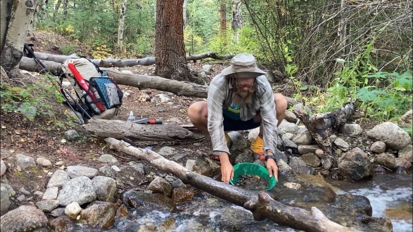
The author taking a side-trip for gold panning along the Collegiate Loop.
Side Trips and Variations
Endless side trips and variations abound, including opportunities to climb 14ers.
Missouri Mountain, Mt. Belford, Mt. Oxford: From the intersection of the Collegiate Loop and the Sheep Gulch Trailhead, follow Sheep Gulch down to Co Rd. 390. Hitch or walk 1.8 miles east on this dirt road to the Go to the Missouri Gulch Trailhead.
Mt. Huron: From the intersection of the Collegiate Loop and the Mt. Huron trailhead, head to the start of the Mt. Huron hike.
La Plata: Near the North Fork of Clear Creek, you can walk or hitch to the West Winfield Trailhead for La Plata from Co Rd. 390.
Updates for 2024
As of 2024, there are several new sections of trail.
New trail at Mile 37.6: There is a new section of Collegiate West/CDT just south of Lake Ann Pass. This new trail is in great condition and avoids the old section of trail along Texas Creek that is shared with dirt bikes and motorcycles. It lasts 6.5 miles (compared to the 9.0 miles on the old route) with at least 8 water sources. It’s shown on the FarOut app but without water sources. We noticed at least 4 spots for camping along the way and camped at a beautiful one near water below treeline.
New trail at Fooses Creek at Mile 81.1: From Monarch Crest, the descent into Fooses Creek used to be loose and steep. For 2024, it’s been re-routed and re-designed to include many more switchbacks.
Food storage and bears: The USFS issued an order requiring bear canisters or adequate bear hangs. Keep in mind that much of the route is above treeline, and the Colorado Trail Foundation recommends bear canisters for the entire route. Call the ranger district for more details.
Closed sections of trail: As of June 2026, there are no closures. See the Colorado Trail Foundation website for closures and alerts.
Getting There
By Plane
The Denver International Airport is surely the most affordable. Public transit (see below) can connect you to the upper Arkansas Valley and the jumping-off points.
Public Transit
Take the A Line Train from DEN airport to Union Station.
Then, take the Bustang bus route to close to the trail.
If starting at Buena Vista:
Take the Bustang route that makes stops in Buena Vista
If starting at Cottonwood Pass:
Take the Bustang to Crested Butte
If starting at Monarch Pass:
If starting at Interlaken:
Take the Bustang from Denver to Frisco.
Then, take the Summit Stage bus Lake County Link to Leadville.
Then, hitchhike or get a shuttle to the Interlaken Trailhead.
Shuttle Services and Trail Angels
The list maintained by the Colorado Trail Foundation is the best source for shuttle and local driver information.
By Car
I live in the Colorado mountains and drove to the area to begin my hike. I spent two days in Leadville, getting last-minute supplies and shipping my food resupply via UPS.
Long-term parking in the area can be tricky. I would not recommend leaving a car for two weeks at a trailhead. Though it may be allowed by the National Forest Service, it can be risky for break-ins. I parked at a friend's property two miles from the Interlaken TH. The CTF angels and shuttlers list is a good starting point for finding longer-term parking for your vehicle if you drive to the area.

The Cottonwood Pass trailhead is a high trailhead at 12,126 feet along a good dirt road.
Trailheads
These are our favorite average passenger car-accessible trailheads along the Loop. Each is a possible starting point for a thru-hike, and all are great places to day hike, acclimatize, or start a shorter section of the trail.
| Trailhead | Road status | Trail conditions by trailhead |
|---|---|---|
| Interlaken TH | dirt road | Flat aspen forest with lake views |
| Winfield TH | dirt road | Great fishing and historic town |
| Cottonwood Pass TH | paved road | Amazing Continental Divide hiking |
| Boss Lake TH | dirt road | Beautiful hike up to Boss Lake |
| Monarch Crest TH | paved road | A gondola ride if you want |
| Foose Creek TH | dirt road | Great mountain biking and hiking |
| Angel of Shavano TH | dirt road | Campground and hiking |
| Chalk Creek TH | paved road | Fantastic rugged scenery |
| Avalanche TH | paved road | Great fishing and mellow hiking |
Post Trip Favorite Restaurant/Bakery/Brewery/etc.
Leadville: Tennessee Pass Cafe and High Mountain Pies
Tennessee Pass Cafe on the main drag in Leadville is perfect for an excellent sit-down dinner and a microbrew. I’ve had an excellent baked trout here, and there’s usually a big yummy main course salad on the menu.
If you’re craving a pizza, you can’t beat High Mountain Pies in Leadville. It’s popular for good reason, and the outdoor seating is often full. Call your order ahead, and walk to one of Leadville’s parks to chow down.
Buena Vista: House Rock Kitchen
The House Rock Kitchen on Main St in Buena Vista has the best outdoor seating in town and great sandwiches and bowls with lots of fresh veggies. The Moroccan BBQ bowl and roasted Brussel sprouts are my favorites.

Fly fishing is allowed along the Collegiate Loop route and can be a fun on-trail hobby. Be sure to pick up a Colorado Fishing License before you go.
Regulations
Follow Leave No Trace Ethics at all times. Carry your trash to the next receptacle. Be tidy and clean when camping.
Practice good trail etiquette and yield to other users. Some sections of trail are open to mountain bikes and horses. Hikers should yield to both bicycles and horses.
Fire restrictions will most likely be in place, either in Stage 1 or Stage 2. Plan to NOT have campfires during your hike.
Respect the very few places along the way where camping is prohibited, either for restoration near or sensitive species protection near water.
Respect private property. The trail crosses several ranches and is routed along roads near Mt. Princeton Hot Springs and Fooses Creek trailhead. Plan your campsites to be on public land.
Water Planning
There’s plenty of water along the route, even late in the summer. There were only 3 stretches of more than 6 miles between water sources along the route – and none more than 10 miles. The Colorado Trail Foundation’s Databook and the FarOut App do not document many water sources because there are so many. For those like me who always try to carry the minimum water weight, recent comments in the Farout app are your best friend for what is running and what has gone dry.
Food Storage
In recent years, bear activity on the Colorado Trail and Collegiate Loop has increased. As of 2024, the US Forest Service is urging and possibly even requiring the use of a bear canister for the entire Colorado Trail. You can read more on the Colorado Trail Foundation website. Many hikers we saw were carrying bear canisters.
We recommend additionally keeping a clean camp and containing the smells from your trash and food. We also recommend not camping at a road crossing with car campers. See this Food Storage story or REI’s Bear Canister story for more information on the subject.

Collegiate Loop gear laid out and organized.
Gear SELECTION
My gear for this trip was a standard 3-season thru hiking kit, with some luxury items added. I fly-fished and panned for gold pretty much every day and was happy to carry that extra gear. A snowstorm is always possible in the Rocky Mountains, so have a plan for how you would cope in that scenario.
This Youtube video provides a complete overview of my gear selection, clothing, and food supplies.
BACKPACK
I packed my kit in a Hyperlite Mountain Gear Windrider 55 for the hike. It's great for up to a 30 lb load, nearly waterproof, and has excellent outside pockets and lashing. The volume was just right, as I don't mind a few items lashed to the outside and in the pockets. See our Best Backpacking Backpacks guide for some more recommendations.
TENT
I hiked in mid-September, with some wind and snow being more of a possibility than the summer season, and chose the Black Diamond Firstlight tent for shelter. This year was rainy during the Colorado hiking season, and the Collegiate Loop and the Colorado Trail during July and August are both trips I’d suggest thru-hikers strongly consider an enclosed tent as opposed to a tarp-type shelter. See here our recommendations for the best lightweight backpacking tents.
SLEEPING BAG
The Enlightened Equipment Revelation 20 quilt served me well, but I am a warm sleeper and don’t mind a predawn start if I'm too cold to sleep. A 20-degree mummy bag is our recommendation for most backpackers and would be appropriate for the popular July and August season. Consider a warmer sleeping system for a late September trip like mine. See our Best Backpacking Quilts guide or our Best Sleeping Bags guide for more recommendations.
SLEEPING PAD
I chose a Therm-a-Rest NeoAir XLite for this hike for its compactness and excellent comfort. Alas, I’m not the most gentle with gear, and my inflatable mattress suffered from small, unfindable leaks that made it deflate the last few nights of the hike. We recommend an inflatable air mattress for most hikers. I think I’ll stick with a Z-Lite Sol for my future trips. See our Best Sleeping Pads guide for more recommendations.

A gear layout of what the author wore on the Collegiate Loop backpacking trip.
What to Wear
Wear a standard 3-season hiking costume with extra sun protection for above treeline days. If you wouldn't usually take a warm hat and gloves, do so for this Loop.
With a favorable long-term forecast, I chose to travel relatively light on the clothing front, even for September. Having a full tent gave me peace of mind about this choice, as I could wait out an unpredicted storm for which my clothing would have been inadequate.
If you're hiking in the fall, consider wearing hunter-orange hats and clothing.
Rain Jacket
You'll want a Best Lightweight Rain Jacket as rain can happen any afternoon in Colorado.
Jacket
Don't forget a warm down jacket or synthetic jacket!
SHOES
This hike is great for trail running shoes with a smooth tread underfoot. I wore a pair of Altra Timp trail running shoes with a pair of Dirty Girl gaiters to keep the dirt and twigs out. There are a few rocky sections of trail where the minimal cushioning of the Timp’s was noticeable, but on 95% of the tread, they were awesome. See our Best Men’s Trail Running Shoes and Best Women’s Trail Running Shoes guide for more recommendations.

About the Author
Brandon Lampley is an all-around outdoor enthusiast who comes to Treeline Review from Outdoor Gear Lab, where he was Senior Editor. Brandon has summited Denali and Ama Dablam and pioneered first ascents in the Indian and Chinese Himalaya. His bigwall climbs include several El Cap routes in Yosemite. He’s spent a month kayaking the Sea of Cortes, bike toured across the U.S. several times, and thru-hiked the Pacific Crest Trail and the Appalachian Trail.
For three years, Brandon lived and worked in Phortse, Nepal as the project director of the Khumbu Climbing Center where he worked alongside Nepali climbers to increase safety for high-altitude climbers and workers.
When he’s not on a long trip or traveling, Brandon lives in his van exploring the U.S. and has biked and climbed in 48 states and 20+ countries. Most recently, he can be found gold-panning in the mountains of North Carolina. He holds degrees in Environmental Science, Geology, and Psychology from Duke University. You can see all his stories on his author page.


