Hiking and Backpacking the California Riding Hiking Trail in Joshua Tree
37-mile trail of winter and spring desert backpacking across Joshua Tree National Park
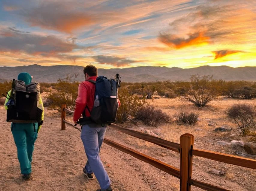
Sunrise at the Northern Entrance trailhead of the California Riding and Hiking Trail in Joshua Tree National Park. Photo by Liz Thomas
January 25th, 2026
Home → Trip Guides → Thru-hikes for Working People
The California Riding Hiking Trail in Joshua Tree National Park is a moderate backpacking trip, perfect for winter and spring wildflower viewing that shows off the variety of the Mojave desert landscape—all on foot.
I've thru-hiked the trail 3 times (in both directions), and I am here to share the tips and tricks that helped me have the best trip possible on this incredible trail.
Distance: 37 miles (one-way), 72 round trip
Days: 3-5 days
Elevation gain/loss: 3,100 feet/1100 feet (max elevation 5,155 feet)
Best season: spring
Permits: online registration at recreation.gov
Difficulty: moderate
Looking for a similar trail? Check out the Santa Monica Mountains Backbone Trail
We create reader-supported, objective, independently-selected gear reviews. This story may contain affiliate links, which help fund our website. When you click on the links to purchase gear, we may get a commission, without costing you an extra cent. Thank you for supporting our work and mission of outdoor coverage for every body! Learn more.
California Riding & Hiking Trail Background Info

The lower elevation section of the California Riding and Hiking Trail in Joshua Tree National Park has interesting rock formations and open wide views. Photo by Kate Hoch
The California Riding & Hiking Trail in Joshua Tree National Park traverses the entire Western part of the park, going from the Black Rock Campground to the North Entrance. Along the way, you'll see the Mojave Desert–from the dry cholla lower elevations to the lush Joshua Tree groves at nearly 5,000 feet.
Along the way, you'll pass highlights of the park, including the dense Joshua Tree forest of Covington Flat, the jumbo boulders of Ryan campground, and the remote area near Quail Mountain, the highest peak in the Park. In Spring, wildflower viewing can be incredible with blooming yuccas and Joshua Trees all over the landscape.
In 1945, The California Riding and Hiking Trail Act established a trail system that was supposed to go through the entire length of the state. The plan fizzled, and few sections remain today. The CRHT across Joshua Tree is one of them—and it is impeccably maintained and signed.
Please note that to enter the park, you must pay an entrance fee or have an Annual National Park Pass.
Highlights
Experience many different areas in Joshua Tree National Park away from the crowds and all on foot, watching changes geology and plant life along the way
The quiet and solitude of the desert location are not too far from major population areas and airports.
It's one of few backpacking trails that can be hiked in the winter snow-free.
It’s a well-maintained and signed trail with only a few miles of notable elevation gain. Terrain-wise, its suitable for beginner backpackers, although the navigation and water carries may require more advanced skills.
You get to see epic views of the snow-covered San Bernardino mountain range and San Jacinto with desert scenery in the foreground.
There’s excellent wildflower viewing in the spring.
Desert sunrises and sunsets
There’s also the ability to take side trips to famous landmarks like Arch Rock and Quail Mountain.
Challenges
No water along the entire route. Even in years of high water, the Park forbids hikers from consuming natural water to give wildlife access to a most precious resource in the desert.
You must cache water along the route and pack out any bottles you use.
Exposure to both sun and wind.
Sandy and rocky trails can contribute to blisters, especially on hotter days. I recommend reading How to Take Care of Your Feet While Hiking and Backpacking.
You're in the high desert (3000-4000 feet), which can take some time to acclimate to elevation and dry air. Spend a day acclimating. Bring electrolytes.
There are no established campsites (unless you make a reservation at one of the campgrounds). You will need skills in campsite placement and how to properly go to the bathroom in the backcountry.
GEAR CHECKLIST
Here is a quick checklist. For a more thorough discussion, skip below.
| CHRT GEAR | OUR SUGGESTIONS | MORE OPTIONS |
|---|---|---|
| Gear | ||
| Tent | NEMO Hornet Elite OSMO 1P Tent | Best Backpacking Tents |
| Backpack | Six Moon Designs Swift X Backpack | Best Lightweight Backpacks |
| Sleeping bag/ quilt | Warmer than you think you need | Best Backpacking Sleeping Bags Best Backpacking Quilts |
| Sleeping pad | Warmer than you think you need | Best Sleeping Pads For Backpacking |

A blooming Joshua Tree in the Black Rock Canyon area. Hiking the California Riding and Hiking Trail in the spring means great wildflower viewing. Photo by Liz Thomas
Best Season to hike the crht
The California Riding and Hiking Trail in Joshua Tree National Park is best hiked in March or April when wildflowers bloom. November through February during winter months are also a great option as temperatures are milder than most other backpacking destinations that time of year. Sun and heat exposure in Joshua Tree can easily be over 100F from May to September. Avoid this trip during the peak of summer.

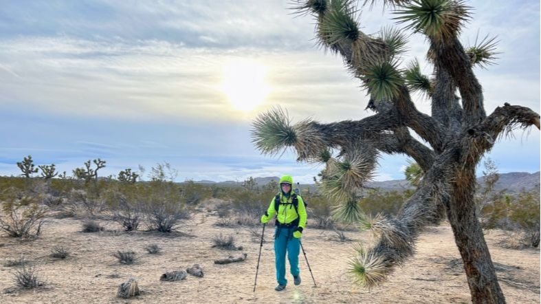
Navigating around cactus can be a challenge on the California Riding and Hiking Trail in Joshua Tree National Park. Photo by Liz Thomas
Difficulty and Skills
Navigation
The CRHT is generally well-marked with mileage signs every mile showing in both directions.
However, you should feel comfortable with dry camping and wild camping. There are no established campsites, so you should have the skill set to find a Leave No Trace campsite.
However, sections of the trail follow desert washes, so they may become obscured after a recent rainstorm. Pay attention to your map and your navigation apps. We recommend the Gaia GPS app.
Rough Terrain / Scrambling / Rock Climbing
The trail is generally sandy, with a few miles that are rockier and have climbing.
Elevation Gain / Elevation Loss
The trail is flat to gradual elevation gain for most of the trip, except for the area between Black Rock Campground and the ridge above Covington Flat. If you plan to hike this section, have the skill set to climb rocky, mountainous, and sometimes loose terrain. Some of the trail goes along the top of ridges, so it may not be suitable for those with severe issues with heights.
California Riding and Hiking Trail vs. Boy Scout Trail: which is the best hike for backpacking in the park?
Both the CRHT and Boy Scout Trail are popular routes in Joshua Tree NP. I’ve hiked both of them multiple times in both directions. Here’s my take:
The California Riding and HIking Trail is longer but generally flatter than the Boy Scout Trail. The Boy Scout Trail has a few narrow canyons that may require briefly using your hands to navigate around boulders, whereas the CRHT is designed as a horse riding trail, so is smoother (though it has some rocky sections). The Boy Scout Trail is 16 miles roundtrip, starting at Keys West trailhead and ends near the Indian Cove campground.

Black Rock Canyon trailhead of the California Riding and Hiking Trail in Joshua Tree National Park. Photo by Kate Hoch
Trailheads
North Entrance backcountry board
For hikers headed Westbound on the California Riding and Hiking Trail, start at the North Entrance backcountry board. The fastest way to access this is via the town of Twentynine Palms.
If you access this trailhead via the Park Boulevard West Entrance (the main entrance to the park), it can take longer as there are often delays around the fee entrance station and people driving slowly through the park.
At the North Entrance trailhead, there's a big gravel parking lot and information kiosk but no trash, water services, or outhouse. Some cell providers may offer service here.
Black rock canyon campground backcountry board
The Black Rock Campground backcountry board is to the north of the entrance to the Black Rock Campground area (the left as you enter the campground). You can access it from the town of Yucca Valley and don't need to enter via a fee station to access it. There's only parking for about 10 cars right at the trailhead, so you may have to find another trailhead in the campground area to park. There's a visitor center, rangers to talk with, flushing toilets, running water, and electricity at the campground. However, there is no food or supplies. Most providers have cell service here.
Geology Tour Road Backcountry Board
This small parking lot off a gravel road can be a starting point for section hikers. You can make reservations for a permit to start or end here at recreation.gov for the CRHT.
Juniper Flat Backcountry Board
This medium-to-large parking lot can be set as a starting point or ending point for section hikes. Make reservations at recreation.gov for backcountry backpacking permits.
Covington Ridge Backcountry Board
This backcountry board and trailhead is accessible by a dirt road that is usually accessible to 2WD cars but can sometimes be rough, especially after rain. The parking area is small, however, there isn't a lot of competition and there are plenty of spots on the side of the road. It's about 6 miles and slow going. As with the other mid-way trailheads, make reservations to start or end here at recreation.gov.

Sunrise after camping near the Covington Flat area of the California Riding and Hiking Trail in Joshua Tree National Park. Photo by Kate Hoch
Permits
As of this year, backpackers will need to get a Joshua Tree Backcountry Backpacking permit at recreation.gov and will be charged a fee of $6 per party (for up to 12 people) to stay up to 14 nights.
You will also be able to get a permit in person at the Joshua Tree Visitor Center or by calling. You may book permits up to 6 months in advance. This new permit system applies to the California Riding and Hiking Trail, Boy Scout Trail and other backpacking routes in the park.
As of January 2026, there is no quota for advance reservations for the California Riding and Hiking Trail (same day quotas could be initiated per zone, so get permits early).
When booking your permit, you'll have to list which zone you'll be camping in.
From East to West, you'll likely be in the following camping zones:
North Entrance
Twin Tanks (near the White Tank campground)
Lost Horse
Juniper Flats
Covington
Black Rock
To learn more about the new permit system, see the Joshua Tree National Park Service website.

Excellent trail maintenance along these stairs on the California Riding and Hiking Trail in Joshua Tree National Park. Photo by Liz Thomas
Which direction to hike the CRHT?
Westbound
Start at California Riding and Hiking Trail trailhead near the North Entrance and end at Black Rock Canyon campground.
Pros
Easiest to set up water caches on the way to the trailhead.
Plentiful parking.
Start the trail with relatively flat walking.
Ends with the most epic views of Joshua Tree forests, Covington Crest, Quail Mountain.
You'll reach the section with the most elevation gain towards the end of the trip (when you've eaten most of the food in your pack).
Ends at a trailhead with water, toilets, and other services.
Will have cell service here for an easier shuttle back to your care (including potentially rideshare options).
Cons
Must start backpacking the same day you get to the trailhead as there is no campground at the trailhead.
Some noise from cars at the beginning.
No water or toilet at your starting point.

Joshua Tree National Park has a distinctive feel. Photo by Kate Hoch
Eastbound
Start at California Riding and Hiking Trail Backcountry board (also known as the Black Rock Canyon Trail) at the Black Rock Canyon Campground. Hike all the way through to end at North Entrance.
Pros
Ability to camp at the Black Rock Canyon Campground at the trailhead the night before your trip (if you make a reservation at this fee campground).
Ability to fill water bottles and talk to rangers about conditions at the Black Rock Nature Center.
Starts the trail with the most epic views of Covington Crest and Joshua Tree forests.
Trail starts with incredible wildflower viewing (if it is Spring), as it’s among the moistest areas of the park.
Even in drier times of year, the trail starts with the densest Joshua Tree groves and biggest trees in the park.
Cons
Limited parking spots. (If you can't find a spot right by the trailhead, ask at the Black Rock Nature Center where to park for overnight backpacking)
Trail starts with climbing and elevation gain
The last few miles of the trail may have some noise from the nearby road, though by that point in the hike, you may not mind as much.
Yo-yo
A yo-yo of the California Riding and Hiking Trail means hiking the trail in its entirety in one direction and then turning around and going back the way you came. It takes most people 7 days to yo-yo the California Riding and Hiking Trail.
Pros
Extra mileage and get to see the Park in both directions.
Only need one car.
Cons
Must cache extra water and if you don't complete the yo-yo, you must drive back to get water bottles.

An awesome campsite nestled between jumbo granite boulders on the California Riding and Hiking Trail in Joshua Tree National Park. Photo by Kate Hoch
Camping
There are no designated camping areas on the CRHT, so you’re free to camp where you’d like as long as you your spot corresponds to the following regulations:
You need to camp at least 1 mile from trailheads.
You are required to camp at least 500 feet from trails and water sources.
You are not allowed to camp in Day-Use-only areas.
All car campgrounds require prior reservations for camping.
No campfires.
Attaching hammocks or slacklines or other ropes to Joshua trees and junipers is prohibited.
Parking
You are only allowed to park at designated backcountry trailhead parking lots. If you park at parking lots designated for day hiking trails, you may get a ticket or be towed.
Your permit (registered online at recreation.gov) requires you to register your vehicle. Non-registered vehicles will be towed or ticketed.
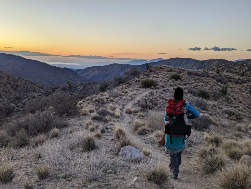
Sunrise along a spine-like ridge looking east towards the Salton Sea on the California Riding and Hiking Trail in Joshua Tree National Park. Photo by Kate Hoch
Route Description
The following route description is for the California Riding and Hiking Trail going westbound, our preferred direction. If you're headed eastbound, flip the directions.
Start at the North Entrance backcountry board. The first four miles feel relatively flat, though you'll slowly ascend through the lowest elevation part of the trail. This is also some of the lowest elevation areas in the park. It will likely feel warmer on this part of the trail than elsewhere. Wildflowers will also bloom here first.
You'll follow washes for the first few miles. Sometimes after a rain storm, the washes can make finding the trail difficult, so keep following the trail marker posts. You'll see house-sized boulders and pass Bullseye Rock, a large boulder with a hole. You'll see a private mining complex in the mountains, pass Belle Campground. This section ends at Twin Tanks backcountry board near the trailhead for Arch Rock and Heart Rock, a short and notable side trail.

Narrow canyons with sandy washes and neat rock formations in the Black Rock Canyon area of the California Riding and Hiking Trail in Joshua Tree National Park. Photo by Kate Hoch
The trail becomes more interesting from the Twin Tanks parking area and spur trail as you ascend through gneiss, a different rock than much of the granite in the park. You'll also pass the Crown Prince Lookout, a granite formation used for planes during WWII. You'll be able to see Ryan Mountain towering above you as well as the Queen Mountains. One of the neatest things about this section is you'll often be able to see the impressie snowy peaks of San Jacinto in one direction, and Toro mountain in the other. They'll be covered in snow in winter and spring.
From the backcountry board at the gravel Geology Tour Road, walk into Queen Valley. You'll pass the ruins of an old miner's cabin, where you may see neatly placed rocks around the foundation and garden. You'll reach a minor saddle that will feel a lot more epic than the elevation gain requires. History buffs may enjoy seeing the remnants of an old rusted pipe used to carry water to miners. This part of the park will feel like it gets a lot more moisture, and you'll start seeing your first junipers. The CRHT comes to Ryan Campground with the notable Headstone Rock, where you may be able to spot some climbers. Then, it's less than a mile to Keys View Road (a good place to cache water).
From the Keys View Road, you'll get some classic Joshua Tree forest views through Lost Horse Valley. In the distance, you'll see Cap Rock, a notable climbing destination. It's mostly flat, if a little sandy, with wide open views of the park. Ignore signs for Stubbe Springs, which is reserved for wildlife. The best part of the trail is ahead. You'll reach a cliff and start descending on switchbacks into a valley and around Quail Mountain.
The next section is remote and is in designated wilderness–and it feels like it. The trail becomes rockier with epic views of mountains ahead. The trail ascends along a spine with fun and interesting walking but few campsites. Before the trail starts heading west, you can leave it to climb Quail Mountain. Otherwise, you'll enter an open valley. The trail continues to Upper Covington Flat past some of the densest and biggest Joshua Trees you've seen yet.
After the Covington Flat backcountry board, you'll walk along the dirt road (or next to it) past some of the densest yucca vegetation yet. Comparing it to the sparse vegetation at the trail's beginning makes it feel like you're walking in a different desert. You'll intersect with the Eureka Peak Trail for a side trip. After climbing the road, you'll finally descend towards the campground.
It's easy to get mixed up and think washes are the trail, so check your map often. Still, this part of the park gets a fair amount of day hikers, so you won't be nearly as alone as in the previous section. There's many different trails in the area, but most intersections are well-signed. If you're here in spring, keep an eye out for blooming yuccas and other desert wildflowers.

The Black Rock Canyon trailhead of the California Riding and Hiking Trail in Joshua Tree National Park. Photo by Kate Hoch
Logistics
As a one-way trip, there are several ways to get from one trailhead to the other on the California Riding and Hiking Trail in Joshua Tree:
Car shuttle
Set up a car shuttle with a vehicle at either trailhead. Both cars drive to your ending trailhead. Then you leave a car at the final destination. Both people hop into the other car and drive to the starting trailhead. You hike to the final trailhead. Then both people drive back to the starting trailhead to retrieve the car. It's about an hour of driving between the two trailheads. You'll need to bring a park pass with you to enter at the North Entrance.
Lyft/Uber/Taxi
You will likely have cell service at the Black Rock Canyon campground. You could feasibly park a car at the North Entrance backcountry board and hike to Black Rock Canyon Campground. Then, you could call Lyft, Uber, or a taxi and have it return you to the North Entrance. When we checked, Lyft operated in Black Rock Canyon, and it would be about $70 one-way to the North Entrance. It is unlikely that a Lyft driver could take you past the national park entrance station, so you may have to walk that last mile in. I haven't done this myself, but I have read of other people who have said it works.
Section-hike
You can choose any of the sections on the trail and hike it either as an out-and-back or set up a car shuttle with two people.
Yo-yo
If you're an experienced backpacker, you can hike to one end, turn around, and hike back to your car. Remember to cache twice as much water if you do this. You can get water the Black Rock Campground at your turn-around point.

A blooming yucca in the Black Rock Canyon area in Joshua Tree as hiked in the spring. Photo by Liz Thomas.
Maps and Guidebook
Gaia
I used the Gaia GPS app on my phone. The trail is well-marked and signed, but it can be easy to mistake a wash for the trail—even for experienced hikers.
Maps
I own and carried both of these maps on my last CRHT hike. Here are my thoughts:
Tom Harrison Joshua Tree National Park map This is my preferred park-wide map that shows the whole CRHT and mileage between points.
National Geographic National Park Map This is a park-wide map that shows the whole CRHT trail. It's more zoomed out and big picture than the Tom Harrison, but will work for planning purposes.
Guidebooks
A foot and a field: Inland Empire by David Harris has the most comprehensive write-up of the trail, broken into sections with parking directions. It also happens to have hundreds of other hikes worth your time in Joshua Tree and beyond throughout the Inland Empire. Written by a friend and hiking partner, it's an excellent resource for anyone who hikes in Southern California.

Hiking along a big Joshua Tree on the California Riding and Hiking Trail. Photo by Kate Hoch.
Getting There
By Plane
The closest airport to Joshua Tree National Park is Palm Springs International Airport (PSP). You can rent a car from Palm Springs from Alamo, Thrifty, Enterprise, Dollar, and more. It'd be a long and expensive Lyft or Uber to Joshua Tree from Palm Springs, though. It takes about an hour to the park entrance when driving from Palm Springs International Aiport.
The nearby Ontario, CA (ONT) airport services more airlines and may have less expensive flights. Car rentals are usually cheaper from Ontario compared to the Palm Springs airport. It takes about 1 hour 45 minutes to drive to Joshua Tree from Ontario International Airport.
By Car
From Los Angeles, take 1-10 to Highway 62. Follow Highway 62 towards Yucca Valley and 29 Palms. If you're starting at the Black Rock Campground, turn right on Joshua Lane and follow it to the campground. If you're starting at the North Entrance, stay on Highway 62 to 29 Palms and turn right, following signs for the North Entrance to the Park. Please note that to enter the park, you must pay an entrance fee. As of 2026, it is $30 for one private vehicle and is good for 7 days. Alternatively, you can use your Annual National Park Pass. As of 2026, the NPS initiated resident and non-resident pricing for the annual pass. It is now $80 for residents and non-US residents pay $250.
Bus and Shuttle Services
Although Joshua Tree operated a shuttle bus service in 2018, that was discontinued. Now, the only way to get into the park is via car, walking, or bicycling. Traffic can be bad getting into the park at peak times (especially weekends), especially at the west entrance. Arriving before 8 am can help.
Post Trip Favorite Restaurant
Frontier Cafe in Yucca Valley has a fun desert vibe and excellent sandwiches. It's next to several vintage stores for those funky Joshua Tree vibes you'll want to experience while you're out there.
Regulations
Follow Leave No Trace Ethics, including camping and pooping far from water.
Group size must be limited to 12 people or less.
Carry a printed and signed version of your permit at all times.
Camp at least 500 feet from the trail, 1 mile from trailheads, and outside of Day Use areas.
You are allowed to cache water, but be sure to pack out your empty bottles.

Hikers and backpackers can see the tip of snowy San Jacinto from the area near Geology Tour Road on the California Riding and Hiking Trail. Photo by Liz Thomas
Resupply
There is no resupply along this route. However, you can cache food in hard-sided containers, like bear canisters. Leave your name, phone number, and expected arrival date on your bear canister.
If you want to resupply, you could coordinate with someone in a car to bring you food at a road crossing or one of the campgrounds nearby the trail.
Black Rock Canyon Campground does not have food for sale. However, the town of Yucca Valley is a mile away and has several grocery stores.

The biggest challenge for many backpackers of the California Riding and Hiking Trail is setting up water caches ahead of time. Be sure to use a Sharpie to write your name, anticipated date of arrival, and phone number on bottles. Photo by Kate Hoch.
Water Planning and Caches
There is no water along the trail. There are no natural water sources, and none of the campgrounds have water faucets except for Black Rock Campground (which is the western terminus).
A water cache is when you bring your own water, usually in gallon jugs, and hide it strategically to retrieve during your backpacking trip.
Joshua Tree National Park’s website says:
“You are welcome to cache water. If you do, please write your name, number, and date of pick up on it. Do not leave any containers behind. Use a thick animal-resistant container. Ravens can peck into and drain thin plastic water jugs.”
You must bring all your water and cache it at trailheads before you hike. There are grocery stores in Yucca Valley and 29 Palms where you can buy water.
As stated above and on the Park Service website, write your name, expected arrival date, and your phone number or an emergency contact so rangers can find you if you don't return to get your jug.
NPS recommends at least 1 gallon of water per day and an additional gallon or more if it is a hot day, which seems low to me. For reference, I backpacked this trail on days in the 40s and 50s, consuming about 1.5 gallons per day (I used some for cooking). How much water you drink depends on your body, how far you are hiking, and temperature, so be flexible. Remember, if you're feeling thirsty, you're already dehydrated! See our guide for Tips for Staying Hydrated (this story is focused on runners but applies to backpackers, too). The desert is unforgiving!
You will need to carry out all your water bottles and dispose of them in a trash can. If you did not use all your water, dump it and pack out the empty bottles to dispose of at a dumpster at a trailhead or campground.
Here are the places where you can cache water on the California Riding and Hiking Trail
Eastbound hike:
| Eastbound Mileage | Notes | |
|---|---|---|
| Black Rock Canyon Campground | 0 | Faucets at the campground |
| Upper Covington Flat Road | 7.5 | Trailhead along 6 miles of slow-going dirt road that requires 4WD after a rain |
| Keys View Road (Juniper Flats Backcountry Registration Board) | 11 | Turn off Park Blvd for 1.1 miles along paved Keys View Road |
| Geology Tour Road | 6.5 | Turn off Park Blvd for 1.5 miles along gravel Geology Tour road |
| Pinto Basin Road | 4.3 | Turn off Park Blvd for 2.3 miles along paved Pinto Basin Road |
| North Entrance | 7.1 | No water |
Yo-Yo hike:
| Westbound Mileage | Notes | |
|---|---|---|
| North Entrance | 0 | No water |
| Pinto Basin Road | 7.1 | Turn off Park Blvd for 2.3 miles along paved Pinto Basin Road |
| Geology Tour Road | 4.3 | Turn off Park Blvd for 1.5 miles along gravel Geology Tour road |
| Keys View Road (Juniper Flats Backcountry Registration Board) | 6.5 | Turn off Park Blvd for 1.1 miles along paved Keys View Road |
| Upper Covington Flat | 11 | Trailhead along 6 miles of slow-going dirt road that requires 4WD after a rain |
| Black Rock Campground | 7.5 | Water tap at campground |
California Riding and Hiking Trail Water Cache Boxes
In 2026, the National Park Service installed lockers to put your water caches inside. This is similar to water cache boxes you see on the Arizona Trail. They look like the brown, metal-sided bear boxes you see at trailheads in Yosemite or Sequoia National Park.
The reason is that the crows and ravens learning to peck through people’s water caches. This spilled water and spread trash across the desert. The lockers protect wildlife and reduce trash. Additionally, this keeps all the water caches in the same spot, which eliminates the social trails that were causing people to trample plants.
Locker locations:
• Geology Tour Road Trailhead (no dumpster)
• Ryan Campground Connector Trailhead (where CRHT meets Ryan Campground)
• Juniper Flats Trailhead
• Upper Covington Flats
How to use them:
Cache water only (Writer’s note: I don’t know why the Park Service calls them “food and water lockers” when they only want water in there)
No trash
Clearly label bottles with your name and planned use dates
Pick up all water containers after your trip
Any bottles left past the labeled date may be removed
Trash receptacles are located near most lockers, except at the Geology Tour Road location. Please pack out what you pack in.
Food Storage and wildlife
Joshua Tree National Park requires that you securely store smellables, food, and garbage away from critters. There are no bears in Joshua Tree, and thus no bear canister requirements. However, rodents, ravens, and coyotes may still be interested in your food and water caches. See REI’s Food Storage story for tips on storing food from smaller animals. As a reminder, use hard-sided containers and plastic water bottles when caching.

There are numerous opportunities for side trips along the California Riding and Hiking Trail, from peaks to family friendly sightseeing destinations. Photo by Liz Thomas.
Side Trips
Belle Campground
A short side trail takes you to the Belle car camping campground. You must make reservations online ahead of time to camp here—there are no walk-ups. However, you can use the facilities (pit toilet and trash cans). If you've got empty water cache bottles, this is a place you can dispose of them.
Arch Rock
The CRHT goes right past the Arch Rock trailhead and you will likely see many day hikers on that popular trail. If you haven't been before, it's a quick, less-than-mile round-trip to see one of the more unique geological features in the park. Heart Rock, a favorite landmark for couples to take photos, is along the trail.
Ryan Campground
The trail comes right up to Ryan Campground and the impressive boulders/rock climbing formations here. As with Belle campground, you'll have to make online reservations far in advance to stay here overnight. However, nearly every CRHT hiker dumps some trash in the dumpster here, and many use the pit toilets.
Quail Mountain
The highest peak in the Park, Quail Mountain requires cross-country travel to the summit. You'll follow along the ridge from one of the CRHT's high points and walk through a burned area to get to the top.
Gear Rentals
Nomad Ventures in the Escondido and Temecula locations may have some backpacking gear to rent. You can always pick up fuel and other backpacking supplies at their Yucca Valley location.

Joshua Tree National Park can be cold at night. Be sure to pack a good sleeping bag. Photo by Liz Thomas.
GeaR DISCUSSION
TENT
We backpacked the CRHT during the winter during a winter rain storm and appreciated the coverage of a lightweight backpacking tent vs. a tarp. I used the NEMO Hornet Elite OSMO Tent backpacking tent and could not have been more happy with my choice for hiking in those conditions.
Wind can be intense in Joshua Tree at all times of the year, so having a windproof tent was very important. You can read my in-depth review of the Hornet Elite OSMO, or see our Best Backpacking Tents guide for more recommendations.
Also note, hammock hanging from Joshua Trees and junipers is prohibited, according to the Park Website, so hammocking is not a good option.
BACKPACK
We needed a backpack that could handle the heavier loads from the longer water carries on the CRHT. I carried the Six Moon Designs Swift X Backpack because it can comfortably carry big water carries and fits my cooler weather backpacking gear. You can read our in-depth review of the Swift X or see our Best Backpacking Backpacks guide for recommendations on lightweight packs designed for comfortably carrying bigger water carries.
SLEEPING BAG
Our group of three hikers used a variety of lightweight and regular sleeping bags on this trip. Ultimately, we all wished we had carried a warmer sleeping bag than we did for our December/January trip. It's easy to forget that even though the desert gets hot during the day, it often gets below freezing at night, especially in the winter. See our Best Sleeping Bags story for more recommendations.
SLEEPING PAD
Our group had the same issue with our sleeping pads. We opted for minimalist choices, and all wished we had brought a sleeping pad with more insulation for backpacking in the winter. See our Best Backpacking Sleeping Pads story for more recommendations.
TREKKING POLES
The CRHT has a few miles with climbing and rockier sections of trails, so we appreciated having hiking poles. Some of us also used our trekking poles to hold up our lightweight tents. See our Best Trekking poles story for more.
COOKING SYSTEM
A backpacker could easily hike this trail stoveless, but I enjoyed having hot food at night. Especially since I backpacked the CRHT during the winter, making hot food at night warmed me up and gave me something to do when it got dark at 5 pm. As with the tent, we discovered having windproof gear was essential in Joshua Tree. I carried the SOTO WindMaster and that was an excellent choice. See our Best Backpacking Stoves story for more recommendations. In addition to carrying a Cooking Pot to boil water, I also brought an empty plastic Taleni gelato jar to cold soak my lunches.
WATER PURIFIER
I did not carry a water purifier on this trip as there is no naturally occurring water along the entire trail. All the water I cached came from faucets or a water factory.
HEADLAMP
Since I backpacked this trail in December and January, it got dark very early. Although I didn't do any night hiking, a bright headlamp was nice for setting up my tent in the dark. If you were to backpack this trail during a warmer season, it might be nice to do some night hiking to escape the heat. See our recommendations in our Best Headlamps story.

Good sun protection is a must for hiking and backpacking in Joshua Tree National Park. Bring sunglasses and consider long sleeve shirts and long pants. Photo by Liz Thomas.
CLOTHING
SHOES OR BOOTS
I found trail running shoes provided the support and stability needed for this backpacking trip. See our Best Trail Running Shoes story.
We saw a lot of backpackers in boots for this trip, especially around the Covington Crest area, which is the rockiest and steepest portion of the trip. If you’d feel more comfortable in boots, check out our Best Hiking Boots story or Best Lightweight Hiking Boots story.
A nice footwear compromise for this trip would’ve been hiking shoes, which are designed to feel like a trail runner but have stability more like a boot. For more, see our Best Hiking Shoes stories (men’s and women’s) for footwear that is more durable and stable than trail runners.
SUN SHIRT
No matter what time of year you hike this trip, you should wear a sun shirt to protect yourself from the intense sun ray exposure. The CRHT and Joshua Tree NP, in general, are very exposed. You're at elevation and there is little shade. See our guide to The Best Sun Shirts for our recommendations.
RAIN JACKET
Although it doesn't often rain in Joshua Tree, when it does—it really pours. It rained every single day during my yo-yo of this trail. Do not do this trail without rain gear, even if the weather forecast looks good. At least carry something minimal like the Marmot PreCip Eco Pro (men’s and women’s), as hypothermia can occur in the high desert during a rainstorm. For more recommendations, see our Best Rain Jackets article.
DOWN OR SYNTHETIC JACKET
The desert can easily be 40 degrees cooler at night than during the day. So even if your temperatures look warm during the day, bring a good insulated jacket for time in camp and early in the morning. I hiked the trail during predicted rainy weather, so I carried a synthetic jacket that was warm when wet. See our recommendations in our Best Synthetic Jackets article. If you prefer down for its better warmth-to-weight ratio, check out our Best Down Jackets guide, which should be a good option under most weather conditions.
For spring conditions, we recommend the Mountain Hardwear Ghost Whisperer (men’s and women’s). You can read our full review of the Ghost Whisperer here.
HIKING PANTS
In our party of three, two people wore hiking pants, and one wore a hiking skirt with baselayer bottoms. Part of this was because it was cool outside while we were hiking. But also, there are many spiky plants in the desert and significant sun exposure, and pants offer extra protection compared to shorts. See our guides to the Best Women's Hiking Pants and Best Men's Hiking Pants for more recommendations.
SHORTS
If you're hiking during the warmer months, you may consider hiking shorts. See our Best Men's Trail Running Shorts guide and Best Women's Trail Running Shorts guide for the most minimalist recommendations. Otherwise, for a more durable pair, see our Best Men's Hiking Shorts guide or Best Thru-hiking Shorts guide.
BASELAYER
Although we wore our sun shirts as our against-the-skin layer, we also had base layers for sleeping at night because the desert night was so cold. For more recommendations, see our Best Baselayers guide.
SOCKS
Desert sand and grit can quickly get into your socks and shoes, so having a tightly woven, well-fitting hiking sock is essential. Additionally, during warmer days, feet can get sweaty, so a good hiking sock and wick away moisture and helps prevent blisters. Check our Best Hiking Socks guide for more recommendations.
WARM HAT
Again, the desert is cold at night. Bring a warm hat for use during the day and sleeping at night.
SUN HAT
The sun exposure is intense in Joshua Tree National Park. There is almost no shade. Check out our Best Sun Hats guide for recommendations.
GLOVES OR MITTENS
Because I backpacked this trail during the winter, I was happy to have gloves and mittens. See our Best Winter Gloves guide for recommendations.
Miscellaneous Gear Items
Map and Compass
First Aid Kit
Sun Protection: don't forget lip balm and sunscreen. See our guide to The Best Face Sunscreen and The Best Body Sunscreen for recommendations.
Sunglasses are essential. See our Best Running Sunglasses guide for sunglasses we like for staying on the face while moving that don't fog up from exertion.
Pocket Knife


