East Highland Way Scotland Backpacking Guide
80-mile thru-hike from fort william to aviemore through cairngorms national park

February 1st, 2026
Home > Trip Guides > Thru Hikes For Working People
Distance: 80 miles
Days: 5 to 9 days
Elevation gain/loss:
Best season(s): Spring, Summer, Fall
Permits: None required
Difficulty: Moderate
The East Highland Way (EHW) is an 80-mile distance hiking route in the Scottish Highlands. It starts where the more-famous West Highland Way ends in the outdoorsy town of Fort William, Scotland and ends in the outdoorsy town of Aviemore in the heart of Cairngorm National Park. I thru-hiked both the West Highland Way and East Highland Way, and found the solitude and route-finding of the East Highland Way a refreshing way to experience hiking in Scotland. Still, the East Highland Way can be hiked from inn-to-inn, with luggage service, and has lunch stops at cafes, giving it a good balance of a self-sufficient route with the pleasures of the amenities offered when hiking in the British Isles.


We create reader-supported, objective, independently-selected gear reviews. This story may contain affiliate links, which help fund our website. When you click on the links to purchase gear, we may get a commission — without costing you an extra cent. Thank you for supporting our work and mission of outdoor coverage for every body! Learn more.

One of many times the East Highland Way is on open moor, here with views of Binnein Shuas mountain and the Mointeach Mhor bog (“great moss land”).
What to know
The East Highland Way doesn’t have the infrastructure of the West Highland Way, meaning you may not see another thru-hiker. It generally is at lower elevations, making it an ideal shoulder season hike when the high country is snowy. Summer walkers will find numerous waterfalls and world-class swimming holes. History buffs will enjoy visiting a 9th century Pict Fort, 15th century Celtic church and cemetery, and ruins of Jacobite barracks. The EHW also passes two whisky distillers, a wildlife refuge, and through several private family estates—which is possible by Scotland’s Right to Roam laws, which allow the freedom to hike and camp on private property.

Hiking through rhododendron forest.
Highs
Solitude and opportunity for route-finding
Ability to stay inn-to-inn each night and have luggage delivered to each inn (so you only have to carry a day pack)
Numerous chances to eat in towns, resupply in town, and not carry a lot of food
Many chances to meet local people
Right to Roam and the Scottish Outdoor Ethic allow camping on private property for free
Easy to tailor the trip to your interests (peaks, history, swimming holes, etc.)

The starting trailhead of the East Highland Way is where the West Highland Way ends in Fort William. West Highland Way hikers take photos at the end with the “Sore Feet’ statue as their finishing photo. Here, it was our starting photo.
Lows and challenges
Flies and chiggers can be an issue as well as ticks during certain seasons
Mud and flooding. Be prepared to get your feet wet. Unlike the West Highland Way, there are some creek crossings (which are referred are called “burns” in Scottish Gaelic)
Logistics for those staying inn-to-inn can be tricky. Towns are not spaced out in convenient distances for most walkers. Depending on how you hike, you may need to arrange shuttles to take you to your B&B.
Views generally aren't as dramatic as the West Highland Way. You won't have views as extreme as Rannoch Moor, Conic Hill, Ben Lomond, or Buachaille Etive Mor looking into Glen Coe--except when you pass through on the bus to get to Fort William.
Since the East Highland Way guidebook was published, some of the forest sections have been logged. Active logging may lead to re-routes—though we were shocked by how well the Scottish Forestry department signed a re-route for the East Highland Way (a route that normally has no signs at all!).
It’s a route not an official trail, so expect some road walking along highways and smaller roads
GEAR SUMMARY
Here is a quick list of the gear I used on the EHW. I will discuss gear and clothing in more detail below.
| EAST HIGHLAND WAY GEAR | OUR PICK(S) | MORE OPTIONS |
|---|---|---|
| Gear | ||
| Backpack | Gossamer Gear Vagabond Jet | Best Adventure Travel Backpacks |
| Headlamp | BioLite Headlamp | Best (and Brightest) Headlamps |
| Water filter | Sawyer Squeeze Water Filter | Best Backpacking Filters and Purifiers |
| Trail runners | Altra Lone Peak Trail-Running Shoes Women's Men's |
Best Women's Trail Running Shoes Best Men's Trail Running Shoes |

Hiking through dense and lush forest on the East Highland Way on Black Craig.
Best Season
The East Highland Way travels through the Scottish Highlands, but generally stays lower than the West Highland Way, making it a good choice for late spring or fall hiking in Scotland. Summer, of course, is the most popular season and offers opportunities for swimming in numerous lakes and streams (as well as a better shot of climbing nearby peaks in good weather).

The East Highland Way follows the River Calder through Glen Banchor past numerous ruins. There’s lots of opportunities here to climb Munros if you want to add to your trip.
Difficulty and Skills
The East Highland Way requires more self sufficiency and navigation skills than the West Highland Way, which is considered a national trail. Still, it requires less orienteering than other Scottish routes like the Cape Wrath Trail.
Navigation
The East Highland Way is a route that connects local trail systems to each other to create a long distance hiking trail. There are very few marked intersections. There are almost no signs that use the term “East Highland Way,” instead opting for local trail names. As a result, you need to pay attention. The guidebook by Kevin Langan was absolutely necessary for this route. Like most long distance trails, the most confusing sections are often near towns, so we also found Google Maps (with cell service) helpful. Occasionally, we used a compass. A phone app like Gaia GPS would be useful as well.
When re-routes were necessary due to logging, we were shocked by how well the Scottish Forestry department signed a re-route for the East Highland Way, detailing every turn. The route is definitely on land managers’ radar, but it seems the intention is to keep it more wild than other distance trails.
Rough Terrain/Scrambling/Rock Climbing
The trail generally sticks to good singletrack, doubletrack, dirt roads, and pavement. Some of the optional side trips to waterfalls and swimming holes may have some scrambling, but the route itself is good enough some may even consider bikepacking it.

The Highland Coo is a cute, furry, horned cow that many believe to be the first domesticated cow. It is bred to be hearty and survive Scotland’s harsh winters. The East Highland Way took us past a farm where Highland Coo were grazing.
Permits
No permits are required to hike the East Highland Way. However, it crosses the Ardverikie Estate, private property owned by some earl or duke. The Scottish Right to Roam allows hikers (and backpackers) to cross the property without permission. However, they do ask that you call head during deer stalking season (stalking is called “hunting” in the US).

An example of a mountain bothy (free 4-sided shelter) on the East Highland Way. While it’s possible to stay at bothys and camping the entire route, we stayed at B&Bs, guest houses, and hotels each night of the trip.
Camping and accommodations
The Scottish Right to Roam laws mean that you are free to camp on private property. Please read the Scottish outdoor Ethic before you go. Whatever you do, do not have campfires, especially during a drought year (as it was when I hiked). It may seem like Scotland is so wet that it never has forest fires, but there was one burning near the trail when I hiked and wildfires happened last year near the town of Aviemore, too.
Almost every town along the trail has B&Bs, hostels, and guest houses to stay. See the guidebook and the resupply section for more information.

Route Summary
Fort William to Spean Bridge
The East Highland Way starts in the town of Fort William, where the West Highland Way ends. We strolled through the cute, main town drag past numerous gear stores, restaurants, and touristy shops, as well as a drugstore. The next 2 miles were on sidewalk through town as you cross the River Nevis with lots of attractions like the Fort William Castle. You’ll pass an Aldi and Marks & Spencer Food Hall (my favorite grocery store in the UK), so you can resupply there or lunch if you took the train in the morning. Above you are the views of Ben Nevis, the tallest mountain in the UK, and the impressive ridge of mountains nearby. We took a break at the Ben Nevis Distillery, which offers tours (book ahead) or a tasting room that is friendly toward walk-ins.
We continued on a bike trail (or “cycle path” as they call them in the UK) until we got to Torlundy, and followed signs to the Nevis Range and Witch’s Trails. You’ll enter the Leanachan Forest, which is famous for downhill skiing and mountain biking. The view to your south is incredible with almost a dozen Munros (the designation given to 4,000 foot tall mountains in the UK).
The day we hiked this section, it was pretty sunny (Scotland was in a drought). We found (and collected) dozens of wild strawberries. Then, we climbed slowly to a paved road (with a farm stand) that leads up to the Ben Nevis ski area. There were views west toward the Ardgour hills and the noticeable Beinn Bhan (771 m) to the northwest.
At Tighnacollie Farm, we took the alternate route that avoids highway road walking through a sheep farm up to the Spean Bridge circular trails. This was our first longer stretch in deeper forest and I liked it.
If you’re pressed for time, I’d recommend starting at Spean Bridge instead of Fort William. We stayed at a hiker-friendly B&B in town for the night where we also saw other walkers on the Great Glen Way, another long trail which travels nearby.

The suspension bridge over the waterfall at the narrow Monessie Gorge. My friends figured out how to climb down the gorge walls and swim in the deep hole under the waterfall while I went to explore the old church. Not recommended but their photos were really cool.
River Spean to Tulloch
The day started with pleasant single track hiking through lush, deciduous forest. We then walked a shady forested low traffic road along the River Spean towards Killiechonate Lodge. The oak trees here were giant and the forest was lush.
We contemplated swimming at the River Cour bridge. The trail then goes through its first official sheep farm at Insh Farm before entering the Forest of Coille Innse to the open fields of Glen Spean. This is the best view yet on the trail with views above and remnants of a 100-year-old narrow gauge railway.

The historic graveyard at Cille Choirill church is a side-trip worth taking on the East Highland Way.
You’ll pass through another farm (be sure to close gates) near a croft near Chilinagi Falls, which according to Scottish folklore, is where the last fairies of Lochaber were seen.
We took the short (5 minute) must-do detour to the Suspension Bridge over Monessie Gorge and waterfall on River Spean. This was a highlight of the trip and a great swimming hole and place for lunch and midday naps.
I took a longer side-trip (maybe 15 minutes) uphill through town to the Cille Choirill Church. On the Bruach Bhrsis, this was the monastic cell for St. Cairell.
The views of Braes of Lochaber (“hills of Lochaber” in Scottish) were incredible. It was highlighted on a BBC TV show, the Monarchs of Glen. In fact, there are so many spots on the East Highland Way that were on that series it almost seems like the route was put together for that purpose.
The graveyard supposedly has many leaders of the last Jacobite uprising of 1745, and is the ancestral burial place of MacDonalds of Keppoch, and has numerous Celtic crosses and memorial cairns that are unlike anything I’d seen before.

If I had to vote, I’d say the best swimming hole on the East Highland Way is An Dubh Lochan with Stob Coire Sgriodain mountain perfectly centered right behind it.
Tulloch to loch laggan
The next section is the trickiest to navigate. The trail takes you to the ruins at Achnacochine (the “field of the disputants”) where cattle reivers met up. From here, it’s easy to lose the path, but if you follow the River Spean and are willing to hop a fence, it should work out. You’ll ford Allt nam Brauch (a small creek) and reach a forest gate where there’s one of few East Highland Way markers. This is one of only a few spots I can think of on the East Highland Way that isn’t ideal for bikepacking.
You’re into a dense Inverlair Forest climbing Coille Chaorainn that will take you high with good views of the valley below and bigger mountains above. Below, you’ll see Inverlair Lodge, where Rudolf Hess, Deputy Leader of Nazi Germany, was held prisoner. The route descends to the town of Tulloch.
The next section had some of my favorite walking. Right off, there were great views and my favorite swimming pond of the trip, An Dubh Lochan with Stob Coire Sgriodain mountain perfectly centered right behind it (and also a great wild camping spot).
We crossed the bridge at Fersit over the River Treig. As we entered the open hillside, we also had views of Chno Dearg at a car park trailheads towards those hills. I yearned to go into that big mountain countryside, but the route turns left through Corrour Forest. We ended the day at Moy Bridge over the Abhainn Ghuilbinn, which had great views, but is not a place we’d recommend trying to hitch a ride or get a taxi to come pick you up. Speaking from experience here.

Swimming at Loch Laggan, which has the largest inland sandy beach in Europe.
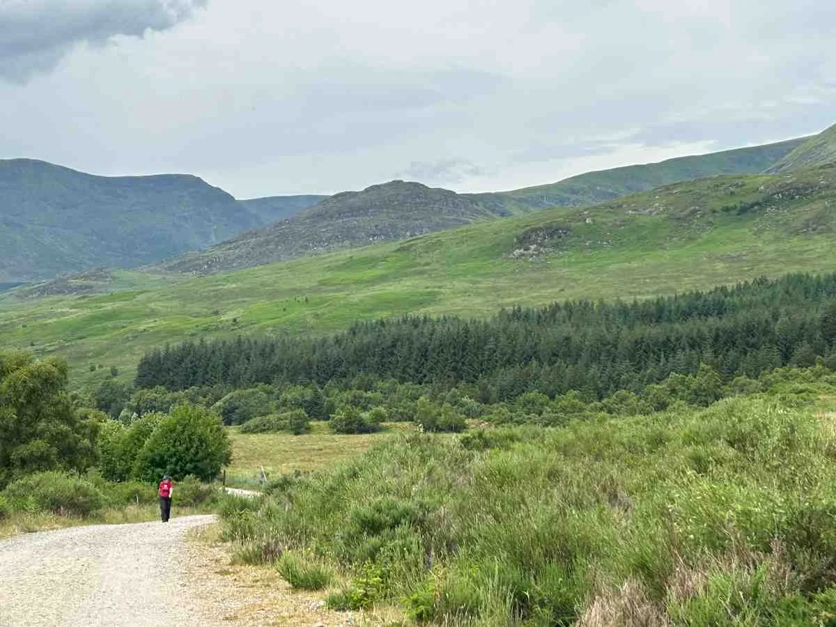
loch laggan to laggan
The next day, we officially entered Cairngorms National Park. We climbed through an open hillside with views of Binnein Shuas mountain and the Mointeach Mhor bog (“great moss land”). The rest of the day was down to the private Ardverikie estate, which is completely fine for walkers to go through due to the Scottish Outdoor Code.

Climbing along the walls of an 9th century fort built by the Picts while thru-hiking the East Highland Way.
We had lunch at the sandy beach on the eastern shore of Loch Laggan, a long skinny lake that is miles long. The funny thing about these private estates is that certain areas haven’t been logged for hundreds of years, so the trees get big and forests are shady and mature and filled with blooming rhododendron and azalea. You’ll pass Ardverikie Castle, which was also used in the Monarchs of Glen TV show, and more recently, as Balmoral Castle in Downton Abbey.
We spent nearly the entire day along Loch Laggan, but it isn't nearly as long and skinny as Loch Ness. At the western end of the Loch Laggan is a white sand beach considered the largest inland beach in Europe. We climbed through more mature forest to open farmland (the site of an ancient sawmill that got moved to the Highland Folk Museum, a free open air museum that the trail goes through a few days later). Then we followed the River Pattock for a short detour to Pattock Falls.
Pattock Falls is located in a rocky gorge with a deep swimming hole and underwater cave. It’s right off the road, but is still a popular wild camping spot. From here, we climbed through the Blackwoods to Fort Dun da Lamh, a hilltop fort and ancient Pictish settlement. The singletrack through the Black Woods to the summit of Black Craig reminded me of the northeast on the Appalachian Trail. But the ruins of the 9th century fort built by early defenders of Scotland were uniquely Scottish.
We descended to the River Spey, one of Scotland’s most famous rivers and namesake for a kind of whisky. The route follows the river to the town of Laggan through green pastures (and our first view of the Highland Coo, an unofficial mascot of Scotland) with views of Cairngorms National Park all around.

Glen Banchor with numerous Munros and other high Scottish mountains in the background.
laggan to newtonmore
The next section was my favorite of the whole trail, but came with the sacrifice of some road walking to get there. It’s been highlighted as an area of priority to put in a new trail by the Cairngorm National Park Authority, but it isn’t done yet.
We climbed from Cluny Castle through manicured forest plantations to the open moorland of Strath an Eilich. We’ve heard this section can be boggy and not as obvious in places, but during a drought, it was easy walking with jaw dropping 360-degree views.
I can’t remember a house or road in sight, which is rare for European hiking. This felt like the most remote part of the hike. It also has Dalnashallag bothy, a backpacker’s cabin. The trail fords the River Calder, following it through Glen Banchor past numerous ruins. To the west and north are several Munros and smaller, but still imposing-looking, mountains.
We ended at a trailhead popular with climbers and hillwalkers and descended a scenic and fun road to Newtonmore, which was perhaps my favorite trail town. The rare Scottish wildcat, a distinctive species that is endangered, lives in this area due to the area’s rare Scots pine ecosystem.

An unexpected perk of hiking the East Highland way was the ability to explore the abandoned Ruthven Barracks from the 18th century.
newtonmore to loch insch watersports center
The route goes through town passing Loch Imrich, a rare kettle hole lake (toll coire) with no outlet stream formed when a receding glacier left behind a block of ice that depressed soft sand underneath. While the trail follows the road on a cycle path, we walked through the free open air Highland Folk museum right by the road. It has re-enactments and working demonstrations, people in old highland costumes, and examples of historic buildings, including thatched roof buildings that look like hobbit holes.
At Kingussie, the East Highland Way joins the Speyside Way extension for much of the rest of the trail. It climbs to the ruins of the Ruthven Barracks with impressive views of the Cairngorm foothills. The barracks are always open and free to enter so we explored. The trail then goes through the Insh Marshes wildlife preserve, passing several “bird hides” (enclosed cabins for birdwatching and a good place to get out of the rain). Insh is a popular birding area and one of the last large unaltered marshlands in Scotland.
You’ll pass the Speyside distillery (alas, tours only happen a few times per month) before crossing the scenic stone River Tromie. Then, we went through a small town to a nice Scots pine forest with views of the Cairngorms and open moor. You’re on a forested trail following the well-marked Badenoch Way all the way to Loch Insh and the Loch Insch Watersports Centre, where we got a beer at the pub, went for a swim, and got a taxi to our hotel in Aviemore.

The 19th century stone Feshiebridge is a popular swimming hole and place to stand up paddle board (SUP). It was a welcome break on the East Highland Way.
loch insch watersports center to aviemore
The last day of hiking into Aviemore, we walked to the free Frank Bruce Sculpture Park, honoring a late local artist who carved large sculptures into trees and stone. After that, the trail took us for a swim at Feshiebridge, an impressive stone bridge at a gorge popular also with stand up paddle boarders. Although it felt like we were close to town and the more visited parts of Cairngorms National Park, we got some solitude in the Inshriach Nature Reserve within the Invereshie and Inshriach National Nature Reserve (essentially a more-protected area within the larger Cairngorms National Park).
These are Caledonian Forests filled with Scots pine and some of the UK’s rarest wildlife. We were really hoping to see the rare Capercaillie (which looks like a more colorful turkey), but no luck. This remote area also has Drake’s Bothy under large Scots Pine trees. From there, we saw Loch Gamhna, where an ancient bronze cauldron was found in shallow peat by a forest warden in the 1960s. The trail becomes very populated around Loch an Eilein, which has a castle on an island. My friends swam out to the island but I was happy to picnic on its banks.
After seeing this many people, it felt like the trail was over. But the East Highland Way kept delivering with more quality wide single track past the Lochan Mor, known locally as the Lily Loch, a water lily filled pond with rare blue dragonflies. It’s popular with photographers.
We took a local-food filled lunch break at the Rothiemurchus Visitor Center. From there, the East Highland Way continues on a cycle path to another trail before finally entering Aviemore. Spoiler alert: there’s no official trail terminus marker, but the old Speyside trail terminus marker is still there (the Speyside way has a new terminus in Newtonmore). You’ll have to settle, as we did, for a nearby other trail end marker: the Snug, Speyside Whisky’s tasting room.

Swimming at the waterfall and deep swimming pool at Pattock Falls on the East Highland Way. A long underwater cave can be entered from the left.
What I’d do differently
The guidebook and route were designed before the pandemic and I believe that many of the hostels and B&Bs along the way are no longer in business. That means that an inn-to-inn version of this hike is logistically much more challenging than the route as written.
If I did it again, I’d wild camp most of the way with a few B&B stops along the way. This would avoid some of the logistical challenges. Notably, we had a hard time coordinating rides for the section between Spean Bridge and Laggan. Had we wildcamped and committed to carrying our goods for a few days, we could have relieved some of the stress of getting to our accommodation before dark.

The Scottish Rights of Way Society posts signs along some intersections on the East Highland Way.
Maps and Guidebooks
APPS
Before I left for the trail, I downloaded the surrounding background maps using the Gaia GPS app. Remember, many sections of the trail do not have cell reception, so it's important to download these maps before you go.
Maps
The guidebook by Kevin Langan says the route can be found on the following maps:
OS Landranger (1:50,000 35, 36, 41, 42)
OS Explorer (1:25,000 392, 393, 402, 403)
However, he also warns that many of the small local trails are not shown on OS maps. We didn’t purchase any of the maps, mostly because it was difficult to find them in the U.S. before we left for our trip. The maps in the guidebook were sufficient for hiking in good visibility summer conditions.
Guidebooks
There is no way you could hike this route without Kevin Langan's guidebook. He designed the route and knows all its minor turns and landmarks. In fact, this was the main mapping resource we used. We didn’t have a GPS track.

The East Highland Way took us on good trail leading to Lochan Mor, known locally as the Lily Loch.
Getting There
I flew from LA to Glasgow, Scotland. From there, I took the West Highland Line train from the Queen Street station to Fort William. You can also grab a bus that goes to Fort William, which was actually kind of fun because it follows parts of the West Highland Way near Glen Coe, including a great view of Ben Lomond, Rannoch Moor, Buachaille Etive Mor, and Glen Coe. The train station and bus station in Fort William is a few blocks from the starting terminus.
Another popular alternative I would love to do is take the Caledonian Sleeper, an overnight train from London.
The ending terminus of the trail in Aviemore is just a few blocks from the train station. A single train will take you all the way back to Glasgow.

Hiking an open glen on the East Highland Way past the Ruins at Achnacochine (the field of the disputants) where cattle reivers met up.
Trailheads
Fort William: The western terminus is in the heart of the town of Fort William, a few blocks from the Fort William train station.
Aviemore: The eastern terminus is in the heart of downtown Aviemore, a few blocks from the train station.

We finished the East Highland Way with a whisky tasting at the Speyside Distillery tasting room in Aviemore.
Favorite Restaurant
Rothiemurchus Visitor Center: it’s nearly the end of the trail and looks like a tourist trap from the outside, but the selection of local Highland Scottish foods here was impressive. We had a great picnic of local strawberries, local cheese, Scottish salmon, and local bread. While we had many fancier and more expensive meals during this hike, our picnic here was my favorite. The quality of everything we got was impressive.
I’m glad we took the time to stop at both the Ben Nevis distillery and Speyside whisky tasting room along the route. While I’m far from a whisky connoisseur, it was a fun addition to the trip that really made it feel like I was in Scotland and doing a different kind of hike.

A mountain bothy in the open moor on the East Highland Way.
Regulations
Learn the Scottish Outdoor Access Code. It is true that everyone has the right to be on most land for recreation—provided you do it responsibly. Here’s a short summary.
Take personal responsibility for your actions. Be prepared and act safely.
Respect others privacy including staying off people’s lawns and private gardens
Take all trash you generate with you
Keep dogs under control
Follow re-routes from local agencies of forestry managers
No campfires
Resupply

Many businesses along the East Highland Way including restaurants, hotels, and fancy B&Bs displayed this sticker showing they welcome hikers.
Spean Bridge: this is where we stayed at a B&B, could resupply at Spar, and had choices for restaurants. Spean Bridge has some nearby attractions, like the Highbridge Jacobite Memorial and WWII Commando Memorial, but they both require walking on the highway for more than a mile and didn’t seem reasonable for most distance hikers, though the guidebook recommends them. There’s a train station that connects to Fort William.
Achluachrach: although the guidebook says there is a hostel and luxury hotel, there were no overnight services anymore that we could find. There is supposedly a store still, but we didn’t see it. The town does have a train station that could perhaps be used to end a day of hiking and ride back to a B&B in River Spean.
Laggan: cute coffee shop and public restroom. We were hoping to make it there for lunch but got there 5 minutes after closing.
Newtonmore: awesome larger town with a grocery store, B&Bs, and multiple restaurants.
Kingussie: hotels and restaurants.
Loch Insch: the water sports center has meals and a hotel (minimum two nights, though). We were able to grab a pint at the pub, though!
Kincraig: near the trail from the water sports center, it has most services.
Aviemore: large town with all services.

The open moor above Corrour Forest near Corrous Station with views of a few Munros to the south along the East Highland Way.
Water Planning
We carried a Sawyer Squeeze water filter but mostly got water from town in the beginning of the day and that was all we needed. The one exception where we asked a local for water was at Feagour near the Inverlair Lodge (however, we crossed the river shortly later so would have been fine).

The East Highland Way took us through the open fields of Glen Spean. This is the best view yet on the trail with views above and remnants of a 100-year-old narrow gauge railway.
Variations
The guidebook recommends numerous side trails and alternates, some of which are shortcuts that involve more roadwalking.
You can also turn this into a large route by combining the East Highland Way with the West Highland Way, Great Glen Way, or Speyside Way, considered some of Scotland's great trails.

Taking a break on the East Highland Way at a trail-side bench (with a book box underneath!) in a Scots Pine forest, a rare type of forest ecosystem only found in the Scottish Highlands.
Gear
I hiked this trail from inn-to-inn, so I didn't carry most of the traditional backpacking gear that I’d use on a trail. Instead, this is what I carried.
BACKPACK
I used the Gossamer Gear Vagabond Jet pack. It fits my water, layers, and snacks. It also was convenient for sightseeing while in Scotland. I especially like the many pockets. I kept my passport in the internal sleeve. I stored essentials that I wanted easy access to like my lip balm in the external zip pocket. I kept my wallet and inreach in the internal zip pocket. I stashed extra layers and sunglasses in the external mesh pockets. All of these made organization easy. Since this hike, we have tested other adventure packs.
WATER FILTER
Although we mostly could refill out water bottles in town, I brought the Sawyer Squeeze filter just in case we ran out of water. It's lightweight, works fast, and requires no pumping or chemicals. I use it inline with my Platypus Hoser for on-demand clean water. Check out our Best Backpacking Water Filters and Purifiers guide for more recommendations.
HEADLAMP
Even though I was so far north that the sun didn't set until 11 pm in summer, I carried a BioLite headlamp as a back-up. It's a winner in our Best Headlamps guide. It's lightweight and bright enough for night hiking, which luckily, I didn't have to do.
Hiking poles
I debated about whether to bring hiking poles for this trip, but ultimately decided it was too difficult to bring on the international flight. For example, the pair we recommend for travel that folds down to a shorter length would've fit in my luggage unlike the longer pair that I couldn't fit in my bag. In retrospect, I wish that I'd brought poles. See our guide to Best Trekking Poles for more information.
MISCELLANEOUS GEAR ITEMS
Map and Compass
First Aid Kit
Sun Protection: don't forget lip balm and sunscreen. See our guide to The Best Face Sunscreen and The Best Body Sunscreen for recommendations.
Pocket Knife

Although Scotland isn’t known for its sunny weather, I was very happy to have packed nothing but sun shirts, my preferred hiking attire. The open moorlands had a lot of sun exposure.
What to wear
SHOES OR BOOTS
We wore the Altra Lone Peaks on the trail, which was excellent. For more, see our Best Trail Running Shoes stories (men’s and women’s) stories.
We saw many backpackers in boots for this trip because sections can be rocky, rooty, and muddy. If you’d feel more comfortable in boots, check out our Best Lightweight Hiking Boots story. I highly recommend quick-drying, non-waterproof versions that will dry more quickly. This trail is wet and waterproof boots will not keep your feet dry.
A nice footwear compromise for this trip would’ve been hiking shoes, designed to feel like a trail runner but have stability more like a boot. For more, see our Best Hiking Shoes stories (men’s and women’s) for footwear that is more durable and stable than trail runners.
SUN SHIRT
The EHW is a low-elevation hike in the woods, sometimes woods that have recently been logged. My friends wore t-shirts. I always thru-hike in sun shirts and wore several of our winners including the Ridge Merino Sun Hoodie. See our guide to The Best Sun Shirts for our recommendations. If you'd prefer an athletic t-shirt, see our guide to Best Men's Running Shirts and Best Women's Running Shirts.
DOWN OR SYNTHETIC JACKET
Since I thought I'd get wet (hey, it is Scotland!), I opted for a warm-when-wet synthetic jacket. See our recommendations in our Best Synthetic Jackets article. If you prefer down for its better warmth-to-weight ratio, check out our Best Down Jackets guide, which should be a good option under most weather conditions.
HIKING PANTS
I wore my Purple Rain Hiking Skirt with tights because I find the pockets useful. Some of my friends wore hiking shorts or trail running shorts. However, given the prevalence of ticks and (more annoyingly) midges, the people who wore hiking pants were the happiest. See our guides to the Best Women's Hiking Pants and Best Men's Hiking Pants for more recommendations.
SOCKS
A good hiking sock can wick away moisture and help prevent blisters. I brought five pairs of Darn Tough socks and had a fresh pair for each day of the trail. Check our Best Hiking Socks guide for more recommendations.
SUN HAT AND SUNGLASSES
FI make sun protection a practice, even on forested trails like the EHW. We were also there during a drought and heat wave, which the locals complained about quite a bit. I was super happy to have brought my prime summer hiking gear and sun protection. Check out our Best Sun Hats guide for recommendations. Be sure to pack a pair of secure sport sunglasses or running sunglasses that will stay on your head during scrambling.


