Wonderland Trail Backpacking Guide
Circumnavigate the highest peak in Washington — Mt. Rainier national park

June 5th, 2026
Home → Trip Guides → Thru Hikes For Working People
Distance: 93 miles
Time to hike entire trail: 5 to 10 days
Elevation gain/loss: 24,900 feet
High Point: Panhandle Gap 6,780’
Low Point: Ipsut Creek Campground 2,300’
Best season: August - September
Wilderness Permits: Required
Difficulty: Strenuous
See the Data Book Mileage Table→
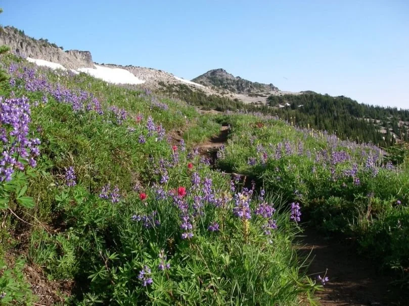
One of the iconic backpacking trips in Washington and Mount Rainier’s premier trail, the Wonderland Trail circumnavigates Mt. Rainier, the highest peak in Washington and the Cascade Mountain Range. At 14,411’ (4,392 meters), Mt. Rainier (also known as Tahoma) is the most topographically prominent mountain in the lower 48. The Wonderland Trail passes through diverse ecosystems, alpine lakes, waterfalls, wildflower meadows, pristine wilderness areas, and old-growth lowland forests. If you’re lucky, you may get glimpses of wildlife, such as mountain goats, bears, or maybe even a mountain lion.
The trail is in good condition overall, but the miles are difficult—total elevation gain is 24,939’ and the trail is rarely flat and often rocky. As a result, most people take 5-10 days to finish the trail. Backcountry camping is limited to designated campsites, which can constrain your mileage.
This guide is a start to your research. Be sure to check at ranger stations for current conditions and updated information.


We create reader-supported, objective, independently-selected gear reviews. This story may contain affiliate links, which help fund our website. When you click on the links to purchase gear, we may get a commission — without costing you an extra cent. Thank you for supporting our work and mission of outdoor coverage for every body! Learn more.

Storms and snow can happen any time of year, but temperatures can dip into the teens in the autumn. Our editor thru-hiked the Wonderland Trail in October. Here’s a photo after a snow storm. Photo by Liz Thomas.
Highlights
Scenery, scenery, and more scenery
Carbon Glacier—at 3,500’, it’s the lowest-elevation glacier in the lower 48 (and also the largest by length, thickness, and volume)
Iconic view of Mt. Rainier reflected in Reflection Lake
Beautiful alpine meadows
Camping in old-growth forests
Picturesque alpine lakes
Challenges
Permit system is difficult to navigate
Trail is popular so permits may be hard to get
Timing required to avoid snow and mosquitos
Elevation gain/loss makes for a strenuous hike
Designated campsites can be constraining
GEAR LIST
Here is a quick list of the gear we used for the Wonderland Trail. For a more thorough discussion about our gear choices, jump here.
| WONDERLAND TRAIL GEAR | OUR PICK | OTHER OPTIONS |
|---|---|---|
| Hardgoods | ||
| Tent | Six Moon Designs Lunar Solo Tent | Best Backpacking Tents Best Ultralight Tents |
| Backpack | Katabatic Gear Onni 65 (discontinued) | Best Lightweight Backpacks |
| Sleeping bag | Katabatic Gear Palisade 30F Quilt | Best Backpacking Sleeping Bags Best Backpacking Quilts |
| Sleeping pad | Therm-a-Rest Z Lite Sol Sleeping Pad | Best Sleeping Pads For Backpacking |
when to hike
Snow can last at the higher elevations well into July
Mosquitoes can be thick into August
July and August are the driest months
Permits may be easier to get after Labor Day
Snow can fall any time of the year
September has the possibility of nice fall colors
Difficulty and Skills
NAVIGATION
Everything is on excellent hiking trail, and trail junctions are (mostly) well marked. However, if there is snow, the trail may be obscured. We recommend using maps (see more below on which maps we recommend) and a compass in addition to a GPS phone mapping app like Gaia GPS with your maps preloaded.
elevation gain
The Wonderland Trail’s elevation gain total is 24,939 feet. Split over 5 to 10 days, the average elevation gain per day ranges from 5,000’ to 2,500’. A 5,000’ day (with a full pack) is significant—which is why most people plan for a 10-day trip rather than a 5-day trip.
wilderness Permits
All Wonderland Trail backcountry sites are permitted. Here is the most current info about permitting on the NPS website. You must camp at a designated campsite on the entire Wonderland Trail. Seventy percent of the permits are reservable in advance, and the remaining thirty percent are walk-ups.
Early Access Lottery
Advance permits are done through an early access lottery. Lottery entries are taken between February 10 and March 3. You can apply to the lottery on recreation.gov. You do not need to provide your itinerary when you apply to the lottery. You're applying for an opportunity to make an itinerary.
If you win a spot in the early access lottery, you will be given a date and time to log in to recreation.gov and make your reservation. The chances of getting the itinerary you want depend on your early access window date.
After around the third week of April, any remaining campsites (except the walk-up permits) are released to the public.
Permits are $12 per person, plus a service fee of $6 for the group, and are non-refundable. You must obtain your permit in person at a ranger station in the park by 12 pm on the day your trip begins. Otherwise, your permit will be canceled.
My experience with the Early Access Lottery
I applied to the Early Access Lottery on 5 days before the end of the application period. On March 14th, I was notified that I won a spot in the lottery for March 27, at 1 pm PDT. March 27th was day 7 of the 30-day lottery, so I thought my chances of getting a complete itinerary were pretty good.

Screen shot of my lottery results email from recreation.gov. Photo courtesy Naomi Hudetz.
Unfortunately, I wasn't able to make a complete itinerary during the dates that I wanted (starting around August 10th). I built my itinerary to the Summerland and Indian Bar campsites – but both of these campsites were full for the dates that I needed (and several days before/after). These campsites are incredibly scenic, so they are also reserved by backpackers who are not hiking the entire WT. Competition is fierce for both Indian Bar and Summerland.
In addition, the recreation.gov system only allows a maximum of 17.5 miles between campsites. Therefore, even though campsites were available beyond Indian Bar and Summerland, I couldn't reserve them because they were farther than 17.5 miles from the previous campsite.
I ended up making a reservation through White River Campground with the hopes that I could fill out the permit as a walk-up.
What I Would Do Differently in the Early Access Lottery
There are several reservable campsites that are not on the Wonderland Trail but are still part of the reservation system. I should have reserved those campsites to complete my itinerary and then try to replace the off-trail campsites as a walk-up. See the table of off-trail campsites below (these campsites are between 1.3 and 3.7 miles off the Wonderland Trail each way).
I could have logged into recreation.gov before my early access window to see which campsites were still available. I should have spent some time looking at which sites were still available before my reservation window, which would have shown me that Summerland and Indian Bar campsites were in short supply. Then, I would have found dates still open for Indian Bar or Summerland and built my itinerary backward from there.
I should have considered starting from someplace other than Longmire. For example, I could have started at Box Canyon and booked a room in Longmire for a nice 13-mile slackpack to start the trip (slackpacking is when you leave most of your gear at a location further up the trail to pick up as you pass through).
I should have considered going counter-clockwise. It's possible that I could have built a better itinerary in that direction.
Walk-up permits
About one-third of permits are on a first-come-first-served basis (a walk-up permit). Here's what you need to know:
Walk-up permits are issued up to 1 day before your trip starts
Dates may already be full, taken by walk-up hikers from several days earlier (especially for the popular campsites)
Pay via credit/debit card
Walk-up permits can’t be issued on the phone or online; you have to go to a Wilderness Information Center
At 5 pm the day before you make a reservation, the rangers put out a notebook with up-to-date campsite availability. Recreation.gov does not have this information.
Your chances are best if you are the first in line and have your itinerary figured out in advance. You're also competing with people at the other Wilderness Information Centers for the remaining spots.
Check out this page if you have more questions about walk-up permits.
My experience with Walk-up Permits
Because I couldn't get a complete itinerary in the early access lottery, I decided to try and get a walk-up permit. I wanted to start earlier than my permit, so I was trying for a completely new itinerary.
The day before I wanted to start, I went to the ranger station after dinner to look at the ranger's notebook with campsite availability. I took photos of every page with my phone and then sat down with the map to see if I could cobble together a complete itinerary.

A page of the Longmire Wilderness Information Center notebook with campsite availability for walk-up permits. Photo courtesy Naomi Hudetz.
Once again, the Summerland and Indian Bar campsites were completely full on the days I needed. However, I could get a complete itinerary if the ranger would give me a long day exception (recreation.gov limits the mileage between campsites to 17.5 miles).
The next morning, I arrived at 6:15 am and was the first in line. The office opens at 7:30 am, and by the time it opened, there were 5 groups behind me. I had my itinerary ready, so the ranger could type it in as quickly as possible (remember – you're also competing with walk-ups at the other permit offices).
Amazingly, the ranger gave me a 22-mile hiking day, so I was able to book a complete itinerary! Yay!!
However, my itinerary was not great. One day was only 6 miles, and then I had a 22-mile day through the most scenic part of the WT (Indian Bar and Summerland). I also had 2 frontcountry campsites – Mowich Lake and White River Campground. I would avoid the White River Campground. It really disrupts the backcountry experience. As for Mowich Lake—as of 2025—the campground there is now only accessible by foot, so it would be a fine option.
What I Would Do Differently for a Walk-up Permit
There's a kind of art to working the permit system. And as I was hiking the WT, I had a lot of time to think about it (and ask fellow hikers about their permit experiences)!
I realized that if I had pushed off my start date by one day, I could have gotten the Indian Bar campground and possibly could have avoided the frontcountry campgrounds. So here's what I would do next time:
Get the permit the day before you want to start. This opens more opportunities for the popular campgrounds.
Consider starting at a trailhead other than Longmire. Check the ranger's list of available campgrounds to see if it helps.
Consider going counter-clockwise.
Consider off-trail campgrounds.
Permit locations: where to get permits
The NPS runs several ranger stations near or on the Wonderland Trail. Here is where you can get permits:
Longmire Wilderness Information Center
Paradise Wilderness Information Center
White River Wilderness Information Center
Carbon River Ranger Station
This NPS page shows where each ranger station is located, important phone numbers, and when (which months) and hours that each ranger station is open.
Backcountry CAMPGROUNDs
Camping in designated sites only, as specified on your permit
1-5 people and up to 2 tents per campsite
6-12 people at group sites
Group sites typically fit 3-5 tents
Not all campgrounds have group sites (see table below)
Every campground has a bear hang or bear box
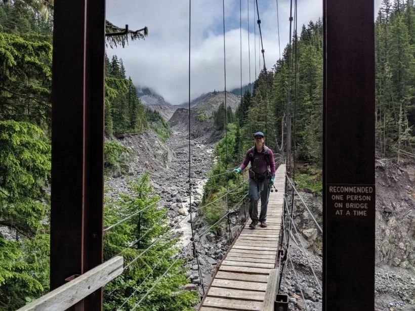
The Wonderland Trail circumnavigates Mt. Rainier crossing the many rivers that call the mountain their headwaters. Most of the rivers have securing crossings, like this beautiful swinging bridge. Photo courtesy Kate Hoch.
how to Increase your chances of getting a wonderland trail Itinerary
The early access lottery is the best way to ensure you get a permit. However, since it is a lottery system, it’s luck of the draw. And as I described above, winning a lottery spot does not guarantee that you’ll be able to get a complete itinerary for the dates you want.
Still, to increase the chances of building a complete itinerary, try some or all of the following:
Start your trip after the Labor Day holiday weekenders have gone home, and the kids are back in school.
Start your trip mid-week.
Because recreation.gov only allows a maximum of 17.5 miles per day, use off-trail campgrounds if you’re stuck with no way to move forward in your itinerary. Then, try to replace those off-trail campsites with a walk-up permit.
Use campgrounds with more sites. Some campgrounds only have 2-3 sites, which will fill up faster than campgrounds with 7-12 sites.
Avoid the more popular campgrounds (e.g., Summerland and Indian Bar are extremely popular and are frequently reserved by non-WT hikers).
Use one or more of the three “frontcountry” campgrounds with backpacker sites (Mowich Lake, Cougar Rock, or White River). However, you won’t have as much of a wilderness experience.
Consider starting at trailheads other than Longmire.
Consider hiking counter-clockwise (most hikers go clockwise).
For walk-up permits, show up at the ranger station early (I arrived at 6:15 am) and be the first in line. Be flexible with your itinerary.
When building your itinerary as a walk-up, look at start dates for both the day of and day after. Sometimes it makes a difference.
Wonderland Trail CampGROUNDS
Main wonderland trail table
| Campground | Elevation (feet) | Frontcountry? | Individual Sites | Group Sites | WT Mile | Mileage from Prior Site (Clockwise) | Mileage from Prior Site (Counter Clockwise) |
|---|---|---|---|---|---|---|---|
| Pyramid Creek | 3,765 | No | 3 | 0 | 3.2 | 3.2 | 2.3 |
| Devil's Dream | 5,060 | No | 7 | 1 | 5.5 | 2.3 | 7.2 |
| South Puyallup River | 4,000 | No | 4 | 1 | 12.7 | 7.2 | 4.1 |
| Klapatche Park | 5,515 | No | 4 | 0 | 16.8 | 4.1 | 2.6 |
| North Puyallup River | 3,750 | No | 3 | 1 | 19.4 | 2.6 | 5.1 |
| Golden Lakes | 5,130 | No | 5 | 1 | 24.5 | 5.1 | 5.7 |
| South Mowich River | 2,605 | No | 3 | 1 | 30.2 | 5.7 | 3.8 |
| Mowich Lake Campground | 4,929 | Yes | 13 | 0 | 34.0 | 3.8 | 5.6 |
| Ipsut Creek | 2,330 | No | 12 | 1 | 39.6 | 5.6 | 3.7 |
| Dick Creek | 4,185 | No | 2 | 0 | 43.3 | 3.7 | 3.6 |
| Mystic Camp | 5,570 | No | 7 | 1 | 46.9 | 3.6 | 4.3 |
| Granite Creek | 5,765 | No | 3 | 1 | 51.2 | 4.3 | 4.6 |
| Sunrise Camp | 6,245 | No | 8 | 2 | 55.8 | 4.6 | 3.3 |
| White River Campground | 4,280 | Yes | 112 | 0 | 59.1 | 3.3 | 7.0 |
| Summerland | 5,940 | No | 5 | 1 | 66.1 | 7.0 | 4.4 |
| Indian Bar | 5,120 | No | 4 | 1 | 70.5 | 4.4 | 6.7 |
| Nickel Creek | 3,385 | No | 3 | 1 | 77.2 | 6.7 | 3.2 |
| Maple Creek | 2,815 | No | 4 | 1 | 80.4 | 3.2 | 6.3 |
| Paradise River | 3,805 | No | 3 | 1 | 86.7 | 6.3 | 2.3 |
| Cougar Rock Campground | 3,180 | Yes | 173 | 5 | 89.0 | 2.3 | 1.5 |
Spray Park Alternate CampGROUNDs Table
| Campground | Elevation (feet) | Frontcountry? | Individual Sites | Group Sites | Spray Park Mile | Mileage from Prior Site (Clockwise) | Mileage from Prior Site (Counter Clockwise) |
|---|---|---|---|---|---|---|---|
| Eagle's Roost | 4,885 | No | 7 | 0 | 1.8 | 1.8 | 4.7 |
| Cataract Valley | 4,620 | No | 6 | 1 | 6.5 | 4.7 | 1.4 |
| Carbon River | 3,195 | No | 4 | 1 | 7.9 | 1.4 | 0.2 |
Off-Trail CamGROUNDs Table
| Campground | Elevation (feet) | Front Country? | Individual Sites | Group Sites | Off-trail miles (each way) | WT Mile (CW from Longmire) | Elevation Gain/ Loss (feet) |
|---|---|---|---|---|---|---|---|
| Yellowstone Cliffs | 5,180 | No | 2 | 0 | 2.7 | 41.9 | 2,343 |
| Berkeley Park | 5,375 | No | 2 | 1 | 1.3 | 54.5 | 1,020 |
| Tamanos Creek | 5,270 | No | 4 | 1 | 3.7 (including 0.7 on a road) | 61.7 | 1,167 |
| Olallie Creek | 3,940 | No | 2 | 1 | 1.3 | 75.2 | 777 |

The Wonderland Trail is well-maintained and signed, but it is important to have navigation tools for when clouds or snow obscure the trail. Photo by Kate Hoch.
Maps, Apps, and Guidebooks
Gaia
We like the Gaia navigation phone app because it’s easy to check if we are on route. Here’s a gpx file to for the route. Remember never to rely only on your phone app or on GPX files that you download.
Maps
We’re big fans of Green Trails Maps, which are easy to read and are printed on waterproof paper. Green Trails does an excellent job of frequently sending out real people to ground-truth trail locations, including a Treeline Review reader.
We carried the Mount Rainier Wonderland Map 269SX. We also carried the National Geographic Trails Illustrated Mount Rainier National Park because-well, we love maps.
Apps
The FarOut app has great information, such as the distance to your next water source and campground (see it on the Atlas Guides website).
Guidebooks & Trip Planning
Guidebooks and trip planning resources for the Wonderland Trail are plentiful and highly recommended:
Hiking the Wonderland Trail: The Complete Guide to Mount Rainier’s Premier Trail by Tami Asars (Amazon)
One Best Hike: Mount Rainier’s Wonderland Trail by Doug Lorain (Amazon)
Plan & Go | Wonderland Trail: All you need to know to complete the classic circuit of Mount Rainier by Alison Newberry (Amazon)
National Park Service Planning Guide (NPS)
Wonderland Guides Itinerary Planner (free)

The Hut at Indian Bar on the Wonderland Trail. Photo by Liz Thomas.
Resupply Locations
The following description shows resupply options for the Wonderland Trail. They’re desribed clockwise starting at Longmire (as mile 0).
Longmire
Wonderland Trail mile: 0
Distance to Mowich Lake Patrol Cabin: 34.1 miles
Elevation gain to Mowich Lake Patrol Cabin: 10,773’
Elevation loss to Mowich Lake Patrol Cabin: 8,657’
Shipping rules: UPS & FedEx ONLY (no Post Office)
Shipping Address:
Mount Rainier National Park
1 NPS Warehouse
Longmire, WA 98397
ATTN: Longmire WIC
Mowich Lake Patrol Cabin
As of 2025, due to closure of a driving bridge that accesses Mowich Lake, you may no longer send a resupply box to the Mowich Lake Patrol Cabin. The DOT website indicates this is a permanent closure.
Sunrise Old Gas Station or White River Campground
OPTION #1 SUNRISE OLD GAS STATION
Wonderland Trail mile: 55.4
Off Trail: 0.8 miles
Shipping rules: USPS, UPS, or FedEx to White River Wilderness Center. Rangers deliver from the WIC to either Sunrise or White River (you must specify the location)
Option #1 Shipping Address:
Mount Rainier National Park
White River WIC
70002 SR 410 East
Enumclaw, WA 98022
Distance to Longmire: 35.1 miles
Elevation gain to Longmire: 7,323’
Elevation loss to Longmire: 10,856’
OPTION #2 WHITE RIVER CAMPGROUND
Wonderland Trail mile: 59.1
Off Trail: 0.1 miles
Shipping rules: USPS, UPS or FedEx to White River Wilderness Center. Rangers deliver from the WIC to either Sunrise or White River (you must specify the location)
Option #2 Shipping Address:
Mount Rainier National Park
White River WIC
70002 SR 410 East
Enumclaw, WA 98022
Distance to Longmire: 31.4 miles
Elevation gain to Longmire: 7,261’
Elevation loss to Longmire: 8,735’
For all resupply locations:
Packages can also be dropped off in person before you start your trip
Food must be stored in a plastic container
Fuel must be hand-delivered and stored separately from your food
Mail your cache so that it arrives at least two weeks before you expect to pick it up
Include the following on the outside of the container:
Name of the permit holder
Permit number
Location the cache will be picked up
Pickup date
Find complete instructions for caching food and fuel here.
Getting There
By Car
Mt. Rainier National Park is easily accessed with a car. The road to Longmire is paved the entire way. Other trailheads may require extensive driving on gravel roads; check before you go to ensure your car can handle the road conditions.
Bus and Shuttle Services
To the best of our knowledge, there is no bus or shuttle service available to Mt. Rainier National Park. From Seattle, King County Metro can take you as far as Puyallup. From there, you might be able to hire an Uber or Lyft to take you the rest of the way to Longmire (which is paved the entire distance). However, you would need to confirm in advance with an Uber or Lyft driver that they would take you that far. On your way back to civilization, you’d probably end up with a multi-part hitch.
Trailheads
There are several access points for the Wonderland Trail. We started at Longmire because we got a walk-up permit (and Longmire issues permits). Access trailheads are as follows:
Longmire Trailhead (permits issued here)
Mowich Lake Trailhead (CLOSED in 2025)
Sunrise Trailhead
White River (permits issued here)
Fryingpan Creek
Box Canyon
Reflection Lakes
Rules and regulations
Here’s a list of some of the regulations in the Park. Be sure to check what is written on your permit and talk to the ranger about conditions before you go.
Follow Leave No Trace Ethics including camping and pooping 200 feet (70 adult paces) from water.
Fires are prohibited.
Dogs and pets are prohibited.
Bikes are prohibited.
Group size is limited to 12 people.
Groups of 6-12 must camp in a group site.
Bio fuel stoves are prohibited (stoves that use sticks, twigs, etc.).
A National Park Pass is required for entrance to the Park.
A Wilderness Permit is required year-round.
Water Planning
Water is plentiful on this hike, even after the snow melts. You’ll pass many reliable creeks, streams, and lakes. Later in the season, there could be an ~8-mile stretch without water. Always know the distance to your next water source and plan accordingly.
Bears and Food Storage
There are no bear canister requirements for this trip. All campgrounds have either a bear hang or bear box. However, be mindful of Principle 6 of Leave No Trace — Respect Wildlife. Never leave your food unsecured.
See REI’s guide to Food Storage for Camping & Backpacking for more on how to protect your food from wildlife (and wildlife from your food).

The Spray Park Waterfall alternate is a popular variation to the Wonderland Trail. Photo by Whitney LaRuffa.
trip Variations
Counter Clockwise vs Clockwise
We hiked clockwise, as the majority of hikers do, but counter-clockwise is an option, too. Some say that going clockwise has gentler ascents and steeper descents, but we don’t think it makes a noticeable difference.
Ipsut Pass or Spray Park?
You can’t go wrong with either of these options, but here are things to consider:
Ipsut Pass is the official Wonderland Trail
Spray Park is 0.7 miles shorter than Ipsut Pass
Ipsut Pass has giant trees along the route
Spray Park has wildflower meadows and is more scenic
Spray Park adds more elevation (uphill and downhill) and chance of snow on the trail
Spray Falls is a popular destination for day hikers
Be sure to carry the right map and compass, especially if you’re taking alternates. We also found a GPS app pre-loaded with the alternate and official track to be useful to have on our phones.

A Wonderland Trail backpacking set-up. Photo by Kate Hoch.
Wonderland Trail Gear CHOICES
This is the gear we carried on the Wonderland Trail. Whether you’re into lightweight backpacking or more traditional backpacking, see our Backpacking Gear section and our Essential Backpacking Accessories story. If you’re headed to the high country in the early spring or late fall, see our Shoulder Season Backpacking Gear article.
BACKPACK
We used the Katabatic Gear Onni 65 (no longer in production) backpack on this trek. It’s lightweight and comfortable but big enough to fit 5 days of food and the tent without an issue. It was an upgrade winner in our previous Best Backpacking Backpack story. Although we’re bummed it’s no longer in production, we recommend reading that article for our suggestions of other backpacks that would be ideal for the Wonderland Trail.
TENT OR TARP
We used the Six Moon Designs Lunar Solo Tent on this trip. It’s a big solo tent, with 26 square feet of interior space PLUS 8.5 square feet of vestibule. It also has a generous 6” deep bathtub floor which helps keep rain and condensation out. It’s also in our PCT Gear List & Strategy story, as well as a winner (Best Affordable tent) in our Best Ultralight Tents story for several years straight.
SLEEPING BAG
We used the Katabatic Gear Palisade 30F quilt on this backpacking trip. A tried and true quilt that’s extremely warm for its weight, the Palisade is a favorite among long-distance hikers. Although it isn’t in our Best Sleeping Bags story (which is dedicated to full zip sleeping bags), it is the top pick in our Best Backpacking Quilts story.
SLEEPING PAD
We used two pads (for one person) on this trip Therm-a-Rest Z-Lite Sol topped with a Therm-a-Rest ProLite (which is no longer made). The Z-Lite was a former winner in our Best Backpacking Sleeping Pads story. We describe the two-pad system in the Long Term Review of Arizona Trail Gear. (The goals of two pads is to have ultimate comfort and reduce chances of puncturing an inflatable pad). That said, the Wonderland Trail has far fewer spiky things than the Arizona Trail, and in the future we would just bring an air pad.
TREKKING POLES
We carried the Black Diamond Trail Ergo Cork trekking poles. The closest model Black Diamond now makes are the Pursuits, which are the top pick in our Best Trekking poles story.
BACKPACKING STOVE
We used the SOTO WindMaster stove on this hike. It’s only 2.3 ounces and works in the wind better than just about any other stove we’ve used. It’s our Overall Winner in our Best Backpacking Stoves story.
POT AND SPOON
We used our TOAKS 750 mL titanium pot and TOAKS long-handled spoon. This lightweight and affordable pot is our Overall Winner in our Best Backpacking Cooking pots story and the spoon is in our Backpacking Essential Accessories story.
WATER FILTER AND STORAGE
We used the Sawyer Squeeze as a gravity filter on this trip. The Squeeze is lightweight and fast. We like that there’s no pumping required and no chemicals involved. It is the overall winner in our Best Backpacking Filters story. See our in-depth review of the Sawyer Squeeze water filter based on thousands of miles of thru-hiking and bikepacking for more information.
HEADLAMP
We carried the BioLite HeadLamp 325 on this trip. It’s bright, lightweight, and has a long battery life. BioLite now has an even better, USB-C fast-charging model, the Range 400. The Range is the new Overall Winner in our Best Headlamps story.
FOOD STORAGE
While bear cans aren’t required on the Wonderland Trail, it’s important to store food safely away from bears, marmots, and whatever other wildlife may be interested in your food. We used the LOKSAK OPSAK odor-proof bags to store our food. All backcountry campgrounds have a bear hang or bear cabinet to store your food. We found this article by REI to be useful in describing food storage techniques for camping in bear country.
Satellite Messenger
We carried a Garmin InReach Mini, which allows two-way texting from the backcountry, spot forecasting, and more. It’s the Overall Winner in our Best Satellite Messengers and Personal Locator beacons story because of its light weight, ease of use, and reliability.
Maps and Compass
We wouldn’t go on a backpacking trip without our trusty Suunto compass and maps (see Maps and Guidebooks).
Bug Protection
Mosquitoes can be fierce in July and early August, so don’t forget a bug head net and insect repellent.
First Aid Kit
Homemade. See our Make Your Own Emergency Kit story.
Rain Jacket
We carried the Montbell Versalite rain jacket. It’s the ultralight winner in our Best Rain Jackets article, and popular with thru-hikers.
Down Jacket
For insulation, we carried the Montbell Thermawrap. It’s also an ultralight winner—this time in our Best Synthetic Jackets article.
Hiking Underwear
Our go-to favorite—the ExOfficio Give-N-Go underwear. They come in multiple styles for men and women. Check out our stories on Best Men’s and Women’s Hiking Underwear for more information on the Give-n-Go and our other favorite hiking underwear.
Warm hat
At 0.8 ounces, the Montbell Chameece inner cap has the perfect amount of warmth for a summer trip. It’s a favorite in our Arizona Trail Gear List.
Gloves/Mittens
We carried the Montbell Climabarrier Trekking Mittens, which we like because they’re lightweight and windproof while allowing for dexterity. They were also in our PCT Gear List & Strategy. If you are in the market for some new gloves for backpacking or hiking, check out our Winter Gloves story.
WHAT TO WEAR
Below is what we wore on the Wonderland Trail. Here are our favorite things to wear while backpacking and hiking from our Hiking Apparel pages.
HIKING SHOES
We wore the Altra Lone Peaks on this trip. The trail was well-maintained and had no snow, so we felt comfortable wearing these lightweight trail runners on this kind of terrain. It is our Long Distance Winners in our Best Trail Running Shoes story.
We saw a lot of backpackers in boots for this trip. If you’d feel more comfortable in boots, check out our Best Hiking Boots story or our Best Lightweight Hiking Boots story.
A nice footwear compromise for this trip would’ve been hiking shoes, which are designed to feel like a trail runner but have stability more like a boot. See our Best Hiking Shoes story for footwear that has more durability and stability than trail runners.
Hiking Shirt
We wore the Icebreaker merino wool 1/2 zip top. We hiked in September so mosquitoes weren’t a concern. See our Best Men’s Hiking Shirts and Best Women's Hiking Shirts guide for more recommendations.
Hiking Socks
We carried 2 pairs of wool socks. Darn Tough Hiker Boot Sock socks are soft, durable, comfortable, and fit like a glove. See our Best Hiking Socks article for more about why we love these socks.
Hiking pants/skirt
We both wore our Prana pants. We have 1000s of miles with these pants and love the durability, pockets, and stretchiness. They’re also on our recommended gear list for the PCT Southbound Gear & Strategy article. Here are articles on Men’s Hiking Pants and Women’s Hiking Pants if you are looking for something new.
Sun hat
We wore the Outdoor Research Sun Runner Cap. It’s a hat that also made our Arizona Trail Gear List. The Sun Runner is technically a Running Hat, but we have a story on Sun Hats too.
About the Author
Naomi Hudetz is director of analytics and digital innovation and leads business strategy and revenue operations for Treeline Review. She brings decades of private sector experience in project management, budget and pricing projection, and long-term business vision, strategy, and goals.
Naomi left her corporate career to pursue her passion for the outdoors. She received the Triple Crown award for hiking for completing the Appalachian Trail, Pacific Crest, and Continental Divide Trail and has hiked numerous other distance routes including the Great Divide Trail across the Canadian Rockies (twice), Grand Enchantment Trail, Pacific Northwest Trail, the Arizona Trail, (most of) the Idaho Centennial Trail, the first known thru-hike of the Blue Mountains Trail, and the Oregon Desert Trail. She serves as Treasurer of the American Long Distance Hiking Association-West and is based in White Salmon, Washington.
Other Resources
For National Forest conditions, road conditions, and trail conditions see the following:
Wilderness Trip Planner (National Park Service)
Mt. Rainier National Park Campgrounds (National Park Service)
Mt. Rainier Wilderness Alerts (National Park Service)
Mt. Rainier National Park Food and Fuel Caching Regulations (National Park Service)
Wonderland Trail Profile Map (National Park Service)
Mt. Rainier National Park Road Status (National Park Service)