Four Pass Loop Backpacking And Trail Running Guide

June 14th, 2026
Home > Trip Reports > Thru Hikes for Working People
I avoided the Maroon Bells Four Pass Loop for years because of the logistical hurdles required to hike this backpacking route. Finally, I resolved to jump through the necessary bureaucratic hoops to see what the big deal was.
I ran the Four Pass Loop on a long summer day and discovered that this route is worth it. And, it isn’t nearly as logistically difficult as I thought. Here’s everything I learned that you should know about backpacking, running, or hiking the Maroon Bells Four Pass Loop.
Distance: 26.2 miles
Days: 1-4
Elevation gain/loss: 7,752 feet
Best season: Summer or early fall
Permits: Wilderness Overnight Permits required, Wilderness self-registration permits for day use, parking reservations required for accessing Maroon Lakes Trailhead
Difficulty: Challenging
We create reader-supported, objective, independently-selected gear reviews. This story may contain affiliate links, which help fund our website. When you click on the links to purchase gear, we may get a commission, without costing you an extra cent. Thank you for supporting our work and mission of outdoor coverage for every body! Learn more.

THE MAROON BELLS FOUR PASS LOOP BACKPACKING, HIKING, AND TRAIL RUNNING GUIDE
The Maroon Bells Four Pass Loop is a 26-mile trail loop that climbs over four passes higher than 12,000 feet through Colorado’s Elk Range. The Four Pass Loop primarily exists on the indigenous lands of the Ute people.
The Four Pass Loop is internationally renowned and a bucket-list item for most backpackers. Located just outside Aspen, Colorado, this trail is very popular in summer and fall, when the aspens all become a fiery yellow.
You’ve probably already seen photos of Maroon Lake, whether or not you realize it. The iconography of this pristinely beautiful alpine lake is ubiquitous in Colorado tourism imagery.

The Four Pass Loop is located in the Maroon Bells-Snowmass Wilderness, one of the five wilderness areas in Colorado designated in the original Wilderness Act of 1964. The Loop is a very challenging hike or run, but the endless views of stunning maroon-rock peaks, alpine meadows, and Aspen forests will reinvigorate you throughout the day.
To avoid the logistical hurdles of obtaining backcountry wilderness camping permits, I ran the Four Pass Loop as a trail run in a single day. But after running the Four Pass Loop in a day, I only want to backpack it more. This guide will cover everything you need to know to backpack the Four Pass Loop, but since it’s 26 miles, you could do it in a day like I did to avoid some of the permit-related challenges.

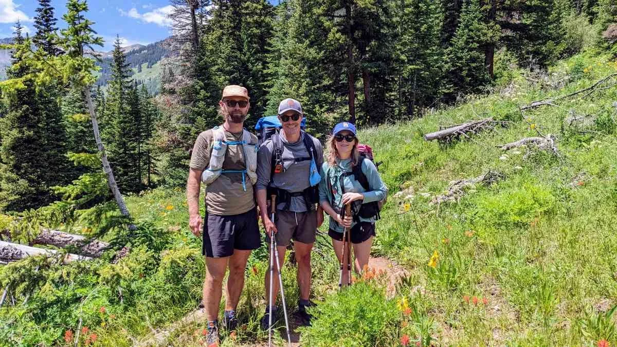
Most people take two to four days to backpack the Four Pass Loop. You must also carry a bear canister to store your food overnight when camping on the Four Pass Loop. If you do it in a day, you can avoid carrying a bear canister. But like I said, this is a world-class backpacking route for a reason, so you should plan to do it as a backpacking trip at least once.
The Four Pass Loop is very well-maintained and well-traveled, especially near the Maroon Bells Scenic Trailhead, which is very popular with day hikers. Once you get a few miles from this trailhead, though, you’ll only see other backpackers for the most part. Even though the trail is well-trodden and primarily smooth dirt, there are many rugged sections. The trail is above 10,000 feet for the entirety of the route other than the start/end point, which is at 9,635 feet. So, you’ll be challenged with high-elevation hiking for the whole trip.


HIGHS
Incredible high-alpine views
Stunning views of the Maroon Bells
Well-maintained trail
Great camping
Potential side trips to Conundrum Hot Springs or 14,000-foot peaks
Beautiful alpine lakes
CHALLENGES
High-elevation hiking with less oxygen
Hiking above treeline for long stretches
Summer storms at high elevation
Four 12,000-foot mountain passes
Navigating the permit process
GEAR LIST
Here is a quick list of the things I brought on my trail run and what I would bring when I backpack the Four Pass Loop. For more detail on why I brought these items, skip below.
| FOUR PASS LOOP GEAR | OUR PICK | OTHER OPTIONS |
|---|---|---|
| Trail-Running Gear | ||
| Hydration vest | Ultimate Direction Race Vest 5.0 | Best Running Hydration Vests |
| Rain/ wind jacket | Ultimate Direction Ultra Jacket Men's Women's |
Best Lightweight Rain Jackets Best Men's Windbreaker Jackets |
| Emergency communication | Garmin inReach Mini 2 | Best Satellite Messengers |
| Water filter | Katadyn BeFree AC 0.5 L Water Filter Bottle | Best Backpacking Water Filters & Purifiers |

BEST SEASON
The Four Pass Loop is best hiked in the summer or early fall, from July through September. Later in the summer is better than earlier, though, because monsoon storms are common in early summer, and snowmelt can make creek crossings treacherous during peak melt. Snowstorms are possible in the fall, even in September, too. However, the changing aspen leaves make dealing with the chilly temperatures well worth it in the fall.
DIFFICULTY AND SKILLS

NAVIGATION
The Four Pass Loop is a loop that follows four different trails. Every trail junction is well marked, and navigation is relatively easy. You should bring a map, compass, and GPS device, though navigation isn’t particularly challenging if you’re comfortable with backcountry navigation.
If doing the loop counter-clockwise as I did, the Four Pass Loop follows the Maroon Snowmass Trail to Snowmass Lake. Then, you take the Geneva Lake trail to the North Fork Crystal River Trail, then the West Maroon Trail back to the Maroon Snowmass trail, where you start at West Maroon Lake.
I only carried GPS maps saved on a smartphone with Gaia GPS for backcountry navigation on the Four Pass Loop. The FarOut Guides Four Pass Loop Hiking Guide is a very useful mobile app guide for hiking the Four Pass Loop, too.
I ran the Four Pass Loop with two friends, so I didn’t carry a paper map as a backup, but I’d highly recommend having the National Geographic Maroon Bells/Redstone/Marble Trail Map or the Colorado Maroon Bells-Snowmass Wilderness Map, especially if tackling the Four Pass Loop by yourself.
ROUGH TERRAIN / SCRAMBLING / ROCK CLIMBING
There is some rough terrain on the Four Pass Loop, but not much that requires intense rock scrambling. You do go over four 12,000-foot mountain passes, and near the top of each pass there is some rock scrambling and rough terrain. Most of the trail is smooth dirt, but not all of it.
ELEVATION GAIN / ELEVATION LOSS
You’ll gain and lose approximately 7,752 feet of elevation over 26 miles on the Four Pass Loop. Be ready to climb on this trail. Each pass requires a 1,000-2,500-foot climb to get to the top. Then, you descend off the pass and climb up to the next pass.
AFTERNOON STORMS
If you’ve never hiked in Colorado, you should know that thunderstorms often develop at high elevations in the afternoon. To avoid storms, it’s best to start early. That’s why they call it an “alpine start,” in fact. Many people camp just before a pass so they can get up and over the pass in the morning before the likelihood of storms increases.
My strategy for avoiding storms is to always watch the skies. If you see dark clouds in the direction you’re going, especially if you’re heading up to a high point, stop and wait to watch if those dark clouds develop into a storm. If more clouds don’t accumulate and you don’t see thunder and lightning in the direction you’re going, then it’s probably safe to go over that pass.
Generally, though, it’s best to complete as much high-elevation travel before the afternoon. I usually shoot to be done with a pass by 2 pm, but some would probably say that even 2 is too late.

PERMITS
You must have Maroon Bells-Snowmass Wilderness Overnight Permits every night you plan to camp along the Four Pass Loop. The wilderness area is divided into different permit zones, so you’ll have to plan how far you want to go every day.
Permits go on sale in blocks, and they’re pretty competitive. They’re not quite getting Taylor Swift tickets competitive, but this isn’t as simple as the self-registration permit system for most wilderness areas in Colorado. Permits are at least available online, so you don’t have to physically go to Aspen just to get permits.
Permits are generally made available for advanced registration in February for early summer through July 31. In mid-June, permits for late summer and fall are made available. In mid-October, permits for winter and early spring are made available.
The permit release schedule for 2026 is as follows. This seems like it will be the schedule for permits every year, but 2023 was the first year this exact permit process was put in place, so we’ll continue to keep an eye on it.
February 15, 2026: Overnight permits for April 1-July 31 are available for advanced reservation at 8 am Mountain Time
June 15, 2026: Overnight permits for August 1-November 30 are available for advanced reservation at 8 am Mountain Time
October 15, 2026: Overnight permits for December 1, 2025-March 31, 2027 are available for advanced reservation at 8 am Mountain Time.
SHUTTLES
Maroon Creek Road, which leads to the Maroon Lake Trailhead, is closed to personal vehicles from May 15 through October 31 unless you have made a reservation in advance. These reservations are limited in quantity and are for a maximum of two days. If you plan on backpacking the Four Pass Loop, taking the shuttle to the trailhead from Aspen is better. The road is also open to personal vehicles from 6 to 8 am, so if you have a good friend willing to drop you off at the top, this is also an option.
Though taking the shuttle to the Maroon Bells Scenic Trailhead is easier than other options, even the shuttle takes some advanced planning. You should reserve the shuttle in advance, though there are sometimes first come, first served, day-of shuttle reservations.
To book the shuttle or get a personal vehicle permit, visit the Aspen Chamber of Commerce Maroon Bells Reservation Page.

ROUTE SUMMARY
The Four Pass Loop feels easy once you’ve made it to the trailhead. Though it’s over four passes, I think the most challenging part of the route is getting to the trailhead. Some might disagree, and this is a challenging backpacking or running route with a lot of elevation gain and loss, but you finally made it to the Four Pass Loop! Congratulations!
The Four Pass Loop starts and ends at Maroon Lake. From the parking area and bathrooms, you’ll start the loop on the Maroon Lake Scenic Trail, an accessible boardwalk and gravel trail that follows the edge of this iconic lake.
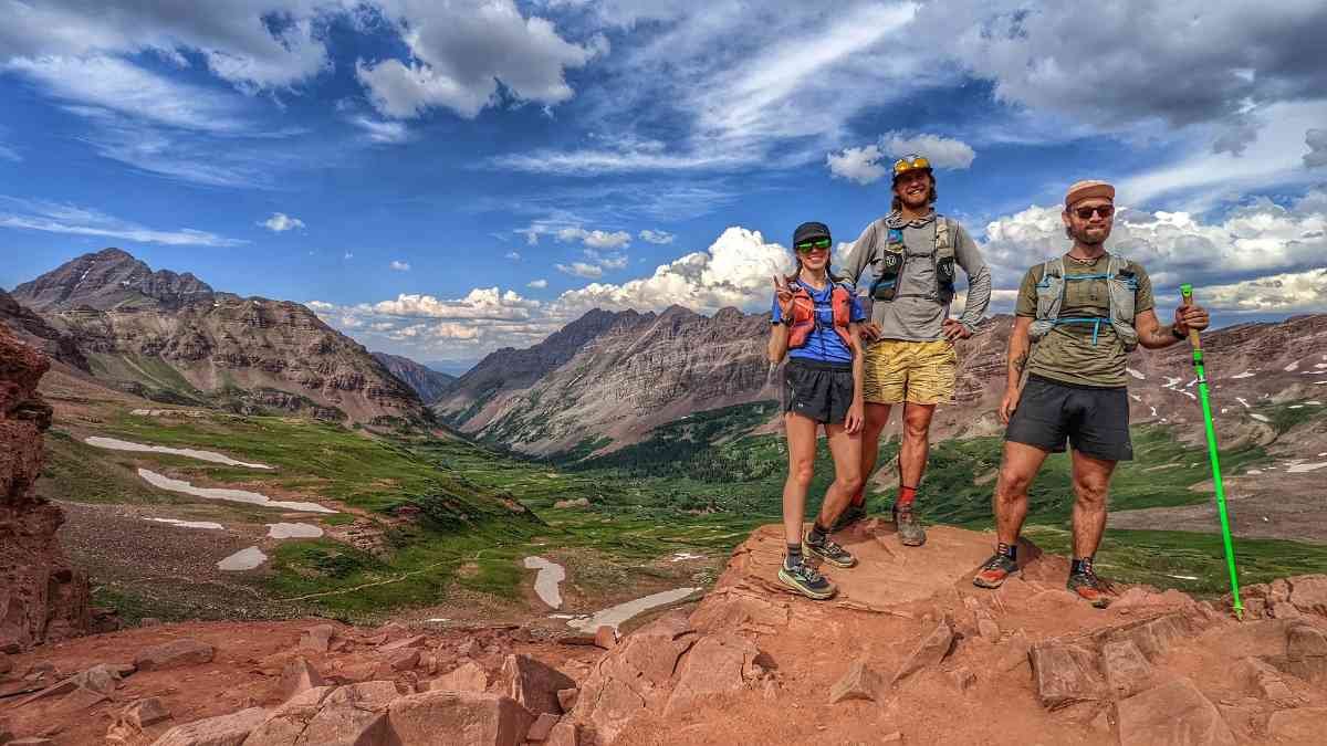
You’ll likely see plenty of other people along Maroon Lake for good reason—this lake is downright stunning. The lighting is usually better in the morning when the sun is hitting the east-facing side of the Maroon Bells, the three red rock peaks that form a backdrop for Maroon Lake and are at the center of the Four Pass Loop. Take your time starting out from here to take it all in.

you quickly begin climbing to your first pass. After a little over a mile, there is a junction where the Maroon Snowmass Trail and West Maroon Trail meet. Here’s where you continue right if you want to go counter-clockwise or left to do the route clockwise.
Since I ran the Four Pass Loop, I went right here to get the two biggest climbs done early. Backpackers often do the route in a clockwise direction since the climb up the West Maroon Valley to West Maroon Pass is less steep. Both directions are great, but I’ll cover the route in the direction I traveled, counter-clockwise, for this guide.
There is great camping in several spots on the way to Buckskin Pass, the first pass when traveling counter-clockwise. You’ll go through several high alpine meadows, through groves of aspen trees, and cross several streams. The climb to Buckskin Pass is just over four miles long and nearly 3,000 feet up, but the views from the top at 12,463 feet are spectacular.
After Buckskin Pass, you’ll descend from 12,600 feet to 10,800 feet. Snowmass Lake is at the bottom of this descent, a massive alpine lake that sits below iconic 14ner Snowmass Mountain and the 13,633-foot Herman Peak. There is excellent camping in this area as well.
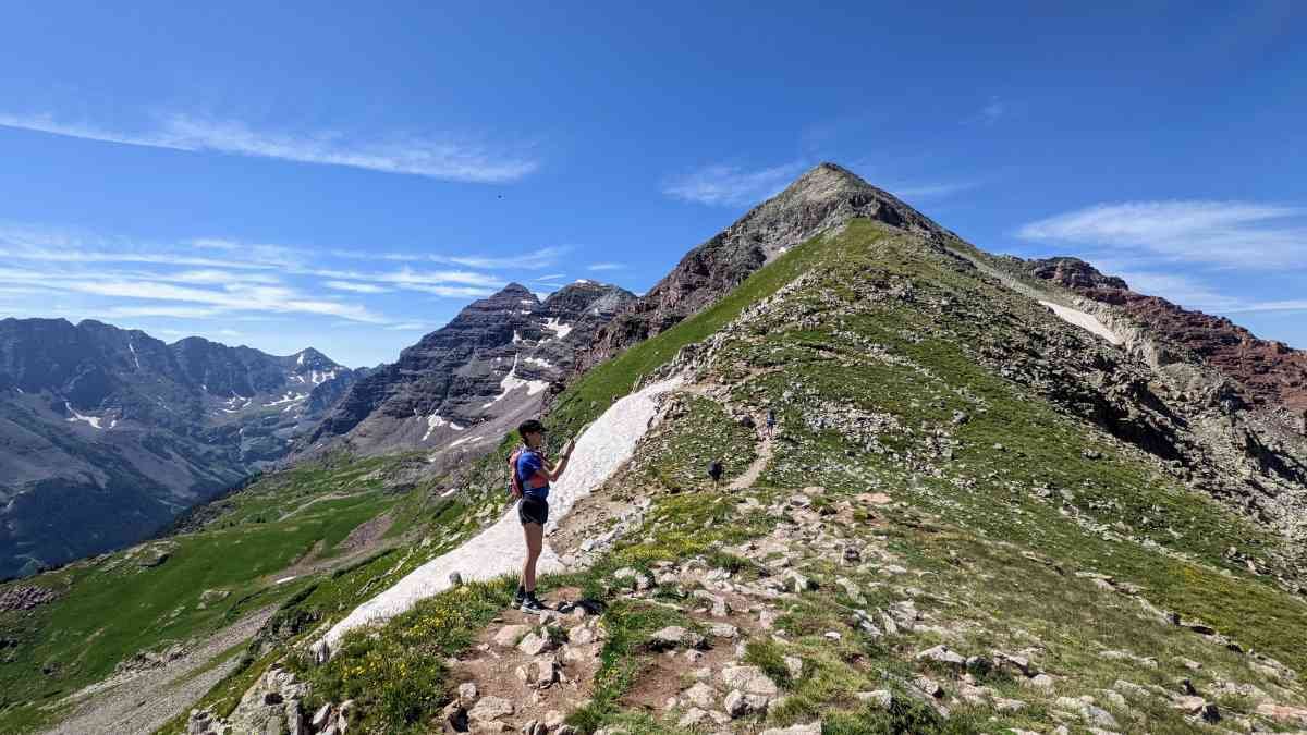
After Snowmass Lake, follow the Geneva Lake Trail as you climb to Trail Rider Pass (12,421 feet). This climb is about three miles long and only ascends 1,600 feet. It will feel easier than Buckskin Pass felt since there isn’t as much elevation gain per mile, but it’s still challenging. From the top of Trail Rider Pass, you can see out into the massive expanse of the western Elk Mountains. To the north are Capitol Peak and Snowmass Mountain, both very challenging 14,000-foot peaks in the area.
After descending 1,000 feet, you’ll arrive at a junction to Geneva Lake. Geneva Lake is another beautiful alpine lake with great camping nearby, but it’s about a mile off the Four Pass Loop route. If you’re camping at Geneva Lake, follow the trail to the right. To stay on the Four Pass Loop, take the North Fork Cutoff Trail to the left.
You’ll traverse across the side of a steep ridge down to an alpine meadow along the North Fork of the Crystal River. Part way down, stay straight at a junction to continue onto the North Fork Crystal River Trail.
After four miles through this meadow, you’ll climb a short but steep section before crossing another high meadow on the way to Frigid Air Pass (12,408 feet). The meadow below Frigid Air Pass is deceptively steep, and on hot sunny days, like when we were there, you may feel like you’re baking in the sun because there is no shade.

We were lucky and had blue skies all day when doing the Four Pass Loop, but those blue skies made this section hot. This section would have been even worse if it were stormy, though. If it looks at all stormy in this area, it’s best to wait out the storms before climbing to Frigid Air Pass, since there are no trees between Frigid Air Pass and West Maroon Pass to take shelter.
After Frigid Air Pass, you stay above treeline for 2 ½ miles to West Maroon Pass (12,446 feet). About halfway to West Maroon Pass, the North Fork Crystal River Trail also joins with the West Maroon Trail. Stay straight at the junction onto West Maroon Trail.
After West Maroon Pass, you’ll descend through a long meadow. The trail is primarily smooth through here, making it easy to cruise downhill to the Maroon Lake Trailhead. This area also has great camping throughout since it’s generally pretty flat. We saw lots of backpackers camped in this area.
You’ll cross several large creeks in this area before the West Maroon Trail meets the West Maroon Creek. Then you travel alongside this creek all the way to Crater Lake. Crater Lake is an excellent place for a break before rejoining the Maroon Snowmass Trail and returning to the Maroon Lake trailhead.
When you arrive at the Maroon Lake Trailhead, you’ve completed the Four Pass Loop! Hopefully you made it back to the trailhead in time to catch the last shuttle down, which leaves at 5 pm. We didn’t make it to the trailhead before the last shuttle and had to hitchhike down the road. Catching a ride with someone else wasn’t very difficult, but if you’re uncomfortable asking strangers for a ride down the road, then be sure you make it back before 5 o’clock.

MAPS AND GUIDEBOOKS
FAROUT

The FarOut Guides Four Pass Loop Hiking Guide is a very useful mobile app guide for hiking the Four Pass Loop. It lists water sources and other important landmarks along the trail. You can leave comments on waypoints and see other hikers’ comments, which is especially helpful for knowing whether or not a water source is flowing.
GAIA
Gaia is my favorite backcountry navigation app. With this app, you can download maps to use when you don’t have a cell signal, create and upload routes from a desktop computer, and much more. You can download tons of different map layers that show everything from topography and trails to current snow depth.
MAPS
National Geographic has a Maroon Bells map, which is helpful for planning and navigation.
GUIDEBOOKS
There is no guidebook for the Four Pass Loop.

GETTING THERE
Getting to Maroon Bells Scenic Trailhead is logistically challenging but very possible. We drove to the Basalt Park & Ride and parked in the overnight parking area. Then, we took a bus to Aspen, where we got on the Maroon Bells Shuttle. The shuttle takes you to the Maroon Lake Scenic Trailhead.
If you have a high-clearance 4x4 vehicle, you can also drive to the West Maroon Trailhead outside of Crested Butte. This trailhead is 3 miles west of the Four Pass Loop and a much rougher road than the road leading to the Maroon Lake Scenic Trailhead, but if your vehicle can make it there, you can start the Four Pass Loop from here.

BY PLANE
Denver International Airport is a large airport you can fly to from most other airports in the United States. From Denver you’ll still be pretty far away from Aspen, but you can rent a car to drive there or catch a connecting flight to the Aspen Airport or the Glenwood Springs Airport.
If you’re flying in to backpack the Four Pass Loop, it’s probably best to use either Glenwood Springs or Carbondale as your basecamp as well. Hotels, food, and other supplies will be less expensive in these towns.
BY CAR
The easiest way to get to the Maroon Lake Trailhead is to drive there, but you must obtain a permit to drive there during the summer months. Instead, drive to one of the Roaring Fork Valley Park & Rides, then take the RFTA bus into Aspen, where you can catch the Maroon Bells Shuttle.
BUS AND SHUTTLE SERVICES
The Roaring Fork Transit Authority operates buses that stop at all the Park & Ride locations in the Roaring Fork Valley, between Glenwood Springs and Aspen.

TRAILHEADS
The main trailhead for accessing the Four Pass Loop is the Maroon Lake Trailhead. This trailhead is closed to personal vehicles during the day unless you have a reservation and permit. The road is open to personal vehicles from 6 a.m. to 8 a.m., so you can have a friend drop you off early in the morning as well.
The West Maroon Trailhead is at the end of a rough dirt road, so it’s not as accessible by passenger car. But if you have a 4x4 vehicle, you can drive to this trailhead three miles west of the Four Pass Loop.
POST-HIKE FOOD
The Aspen Tap is a good spot near the Four Pass Loop to get a beer and food after your adventure.
Mountain Heart Brewing in Carbondale has great beer as well. Carbondale is a less expensive mountain town than Aspen, so many will find it better to celebrate completing the Four Pass Loop here.
The Casey Brewing Taproom in Glenwood Springs is another great option for a post-adventure beer.
Dos Gringos Burritos in Carbondale has breakfast burritos and coffee if you’d rather celebrate finishing the Four Pass Loop in this way.

REGULATIONS
Follow Leave No Trace Ethics
Dogs are allowed on the Four Pass Loop, but they must be leashed.
Only camp in established sites.
Group size must be limited to 10 people or fewer.
You must have Maroon Bells-Snowmass overnight permits to camp along the Four Pass Loop.
All food must be stored in a hard-sided bear canister for overnight backpackers.
CAMPING
You can camp in established campsites along the Four Pass Loop, but you must camp in the permit zone corresponding to your permit each day.
WATER PLANNING
There is plenty of water in most sections of the Four Pass Loop. In general, there is less water at high elevations than you might expect, though. So pay attention to upcoming water sources, especially whenever you’re beginning a climb to another pass. Plan to carry water to the top of every pass because streams near the high points along the Four Pass Loop are less frequent.
Check the FarOut Four Pass Loop Guide for up-to-date water information.
BEARS AND FOOD STORAGE
You are required to store your food in a hard-sided bear canister when camping on the Four Pass Loop. For bear canister recommendations, see REI’s Food Storage story or REI’s Bear Canister story.

SIDE TRIPS
Conundrum Hot Springs is a wildly popular natural hot spring located in the Maroon Bells-Snowmass Wilderness. You need a separate permit to camp at Conundrum Hot Springs, but these hot springs are a short hike away from the Maroon Lake Trailhead and a fantastic post-hike side trip for a soak. They’re very busy, though. And you’re required to use a Wag Bag when camping near Conundrum Hot Springs.
Maroon Peak is a 14,000-foot peak that the Four Pass Loop circumnavigates. You could take a 2.1-mile side trail to the top of this challenging 14er. This is one of the more challenging 14ers in Colorado and requires plenty of class 3 scrambling. Don’t attempt to climb this peak unless you’re very confident in your off-trail mountain climbing abilities.

VARIATIONS
You can hike the Four Pass Loop counterclockwise or clockwise. This guide covers the route going counter-clockwise, but you can do it clockwise, too.
You could also use the West Maroon or Lead King Basin Trailhead to start the Four Pass Loop from a different point on the loop, so you don’t have to deal with the shuttle to the Maroon Lake Trailhead.
Also, if you can’t get backcountry permits for the nights you plan to be on the Four Pass Loop, you could still backpack the loop, but you’ll have to do a little extra distance. You could avoid needing permits by hiking out of the backcountry overnight permit zones each night and then hiking back to the Four Pass Loop the following day. This will require about as much planning as simply getting permits, though, so we only recommend this as a backup option.
This would take some planning, but you could feasibly hike out of the Snowmass Lake overnight permit-required zone by going farther north on the Maroon Snowmass Trail. Then, you could hike past Geneva Lake, to the Geneva Lake/Lead King Basin Trailhead, where you’d also be outside the overnight permit-required zone. You could do the same by hiking out to the West Maroon Trailhead. This would take much longer. It would add roughly 15 miles to the overall distance, and the camping wouldn’t be as scenic, but you could do the Four Pass Loop this way.
GEAR RENTALS
The Glenwood Springs Parks and Recreation Gear Library rents bear canisters, which you’ll need, plus other backpacking equipment.

GEAR SELECTION
Since I did the Four Pass Loop as a run in a single day, I didn’t carry a full backpacking kit. I carried an Ultimate Direction Race Vest 5.0 stuffed with Pro Bars, chips, salami, an Ultimate Direction Ultra Jacket, Garmin InReach Mini, a Katadyn BeFree 0.6 liter water filter, and a Buff.
When I do backpack the Four Pass Loop, here’s the gear I’ll take with me:
TENT
I use the Tarptent Aeon Li Tent because it’s a lightweight tent that does well in windy conditions and has a fully enclosed bug net. The Aeon Li is lighter than a traditional backpacking tent and is a winner in our Best Ultralight Tents guide.
See our Best Backpacking Tents guide for more recommendations.
BACKPACK
I use an Outdoor Vitals CS40 backpack for trips where I need to carry more than four days' worth of food or a bear canister, like on the Four Pass Loop.
See our Best Backpacking Backpacks guide for more recommendations. If you want something lighter, see our Best Running Packs and Fastpacks guide, where the Outdoor Vitals CS40 is a winner. Alternately, if you’re running this route as I did, you should be fine with a Running Hydration Vest.
SLEEPING BAG
I use a Cedar Ridge Outdoors Leconte 20F quilt (no longer manufactured). It’s a high-quality down quilt that has reliably kept me warm for thousands of trail miles. If you're interested in a dedicated sleeping bag instead of a quilt, see our Best Backpacking Sleeping Bags guide. If you want something lighter, see our Best Ultralight Backpacking Quilts guide.
SLEEPING PAD
I use a Therm-a-Rest NeoAir XLite. It’s reliable, keeps me warm, and Therm-a-Rest’s lifetime warranty is no joke. The Therm-a-Rest NeoAir XLite NXT is our mummy winner in our Best Backpacking Sleeping Pads guide.
TREKKING POLES
I used Komperdell Carbon Cloud Vario trekking poles on this trip because they’re lightweight, fold down small, open automatically, and Komperdell has an awesome no-questions-asked repair program.
I recently lost my Paria Tri-fold Carbon Cork trekking poles to the Jackson Hole airport security. Those were my go-to poles for years because they’re inexpensive, lightweight, and fold to a small size when I’m not using them.
For more recommendations, see our Best Trekking poles story.
COOKING SYSTEM
MSR PocketRocket stove, which is the winner in our Best Backpacking Stoves guide
Snowpeak Titanium Spork
See our Best Backpacking Stoves story for more recommendations.
COOKING POT
I use a TOAKS 750 mL pot, which is the overall winner in our Best Backpacking Cookpot guide.
See our Best Cooking Pot section for other cookpot recommendations.
HEADLAMP
I carry a Petzl BINDI Headlamp, which is affordable, bright, and lightweight. Unfortunately, it has been discontinued, so if you can’t find it, see our recommendations in our Best Headlamps story.
SATELLITE MESSENGER
There isn’t much cell reception on the Four Pass Loop. I carried the Garmin InReach Mini 2 because it allows you to send and receive messages from anywhere, including contact search and rescue. You can also use the Inreach Mini 2 to coordinate rides for pick-up after your hike. But, you can’t do this very easily for the Four Pass Loop since the road to the trailhead is closed to passenger cars except between 6 and 8 am.
The InReach Mini 2 is the overall winner in our Best Personal Locator Beacon and Satellite Messenger guide. You can read our in-depth review of the Garmin InReach Mini 2 here.
FOOD STORAGE
I carry a BearVault BV475 for storing my food where a hard-sided bear canister is required, like on the Four Pass Loop.
WATER PURIFIER
I carried the Katadyn BeFree 0.6 liter water filter, which is my go-to water filter for trail running because it fits in the front pockets designed for soft flasks.
I use a Platypus Quickdraw when backpacking, which is the overall winner in our Best Water Filters and Purifiers guide.

WHAT TO WEAR
SHOES OR BOOTS
I used the Merrell Long Sky trail runners on this trip because they’re comfortable, fit my feet well, are very stable, and have a super grippy outsole.
For more recommendations, see our Best Women’s Trail Running Shoes story and Best Men’s Trail Running Shoes guide.
If you’d feel more comfortable in boots, check out our Best Hiking Boots story or our Best Lightweight Hiking Boots story.
A nice footwear compromise between running shoes and hiking boots are hiking shoes, which are designed to feel like a trail runner but have stability more like a boot. See our Best Hiking Shoes story for footwear that’s more durable and stable than trail runners but not as heavy as a boot.
RAIN JACKET
I brought an Ultimate Direction Ultra Rain Jacket for this trip because it’s crazy light and has waterproof flip mittens to keep my hands protected in storms. See our gear review of the Best Lightweight Rain Jackets for other recommendations.
RAIN PANTS
I carry the Ultimate Direction Ultra Pants because they’re lightweight and have zips at the ankles to put on and take off with shoes on. See our Best Rain Pants guide for more recommendations.
DOWN OR SYNTHETIC JACKET
I use the Mountain Hardwear Ghost Whisperer down hoody for an insulated jacket because it’s incredibly lightweight and warm.
See our recommendations in our Best Synthetic Jackets article. If you prefer down for its better warmth-to-weight ratio, check out our Best Down Jackets guide.
FLEECE OR MIDLAYER
I carry a MYOG Polartec Alpha Direct Hoody for a four-ounce mid-layer that’s warm and breathable. See our guide to Best Fleece Jackets for more recommendations.
SUN SHIRT
I use a Free Fly Bamboo Lightweight Hoodie because it’s a bamboo fabric, which doesn’t get too hot and doesn’t stink like polyester. In colder conditions, I wear an Ibex Indie Hoody, which is slightly warmer but has a quarter zip to vent if it gets too warm.
See our Best Sun Shirts guide for more recommendations. If you want a more traditional hiking shirt, see our Best Men’s Hiking Shirts or Best Women’s Hiking Shirts guides for more recommendations.
HIKING PANTS
I didn’t carry hiking pants on this trip because I prefer to hike in running shorts.
See our guides to the Best Women's Hiking Pants and Best Men's Hiking Pants for more recommendations.
SHORTS
I used the Patagonia Strider Pro Shorts on this trip because they have lots of pockets. Patagonia also has some of the best environmental practices of any company.
For more recommendations, see our Best Men's Trail Running Shorts guide, Best Women's Trail Running Shorts guide, Best Men's Hiking Shorts guide, or Best Thru-hiking Shorts guide.
BASE LAYER
I carry the Patagonia Capilene Base Layer Bottoms because they’re lightweight and comfortable. For more recommendations, see our Best Base Layers guide.
HIKING SOCKS
I wore Darn Tough Hiking Socks because they’re extremely durable. Check our Best Hiking Socks guide for more recommendations. If you like something thinner or are running the Four Pass Loop in a Day, we have more ideas in our Best Running Socks guide.
WARM HAT
I carry a MYOG Polartec Alpha Direct warm hat because it’s extremely lightweight. Since I carried a hooded down jacket and hooded alpha mid-layer, I didn’t need a very warm hat.
SUN HAT
I wore a Hoka Performance Hat because it’s comfortable and tightens with a shock cord so it won’t blow off on windy ridges. Check out our Best Sun Hats guide for more recommendations.
GLOVES OR MITTENS
I carried the Rab Power Stretch Contact Gloves because they’re lightweight and warm. For more recommendations on lightweight but warm gloves, see our Best Winter Gloves guide.

MISCELLANEOUS GEAR ITEMS
FIRST AID KIT
4 squares of gauze
Antibiotic ointment
Alcohol wipes
2 large square adhesive bandages
Ibuprofen
SUN PROTECTION
Sunglasses - see our guide to Best Running Sunglasses
Sun Hoody
Sunscreen - see our Best Face Sunscreen and Best Sunscreen for your Body guide for our recommendations
POCKET KNIFE
I carried a Classic Mini Swiss Army Knife on this trip.


