Trans Catalina Trail Hiking and Backpacking Guide
38-MILE BEGINNER-FRIENDLY THRU-HIKE ON CATALINA ISLAND WITH BEACHES, SWIMMING, AND A MILD CLIMATE

February 15th, 2026
Home > Trip Guides > Thru Hikes For Working People
Distance: 38.8 miles (one-way, includes 7.7 mile road back to town)
Days: 4-7 days (including time on the ferry)
Elevation gain/loss: 11,069.6 feet / 10,964.2 feet (includes 7.7 miles)
Best season: spring, winter
Permits: Fee-based reserved campsites required
Difficulty: moderate; some sections are steep and physically challenging
We create reader-supported, objective, independently-selected gear reviews. This story may contain affiliate links, which help fund our website. When you click on the links to purchase gear, we may get a commission, without costing you an extra cent. Thank you for supporting our work and mission of outdoor coverage for every body! Learn more.
BACKGROUND
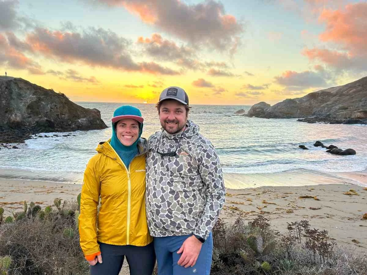
The Trans Catalina Trail (TCT) is a 38-mile hiking and backpacking trail on Santa Catalina Island (aka, Catalina Island), the largest of the Channel Islands off the coast of southern California. It runs from the town of Avalon, CA to Parson's Landing Campsite via the town of Two Harbors, CA. Due to its Mediterranean climate, the TCT has mild temperatures year-round and can even be hiked in winter.
With beach and mountain views, rare wildlife, and beach-side campsites with opportunities for swimming, the Trans Catalina Trail is a good choice for first-time thru-hikers and hiking with dogs in cooler months. With frequent drinking fountains and restrooms, restaurants, and well-spaced out campsites, the TCT is a good option for a first thru-hike. I've hiked the trail three times, both eastbound and westbound. Here are my tips and strategies for the Trans Catalina Trail.

GEAR LIST
This gear list covers what I carried on their various thru-hikes of the TCT. In this TCT gear section, you can learn why I carried what I did on my hikes and what worked and didn't.
| TRANS CATALINA TRAIL GEAR | OUR PICK | OTHER OPTIONS |
|---|---|---|
| Hardgoods | ||
| Tent | Zpacks Duplex Classic Tent | Best Backpacking Tents Best Ultralight Tents |
| Backpack | Osprey Eja Pro 55 Pack (Women's) Osprey Exos Pro 55 Pack (Men's) |
Best Lightweight Backpacks |
| Sleeping bag | Katabatic Palisade 30F Quilt | Best Backpacking Sleeping Bags Best Backpacking Quilts |
| Sleeping pad | Therm-a-Rest NeoAir XTherm Sleeping Pad | Best Sleeping Pads For Backpacking |
SHELTER/TENt
I used a Zpacks Duplex. I loved its spaciousness, despite its very low weight. For those same reasons, it's been in a winner in both our Best Backpacking and Best Ultralight Tents guides.
TREKKING POLES
I used the Gossamer Gear LT5 trekking poles, the winner of best ultralight poles. I fully admit these are not the poles for everyone, and they take a little care in using them because they are SO lightweight. But as an ultra-lighter who sometimes goes pole-free, I was very happy to have had two poles on this trip. To compare these and other trekking poles, read our Best Trekking Poles review.
BACKPACK
I used the Osprey Eja Pro 55 backpack on this trek (the men's version is called the Exos). The 55L capacity on this pack was unnecessarily big for this trip, though I removed the brain from the top to shave a few ounces. The Osprey Eja Pro 55 rides comfortably and weighs less close to 2 lbs. Plus, the Eja/ Exo’s ventilation got them on the list in our Best Backpacking Backpacks guide.
SLEEPING BAG
I used the 30F Katabatic Palisade Quilt on this TCT trip because I checked the forecast and it wasn't supposed to get below 40F during our December hike. I sleep cold and was worried about the storms predicted during my trip. Yet the 30F quilt kept me plenty toasty. You can read our full, in-depth review of the Palisade or our guide to the Best Quilts. Not sold on quilts? See our Best Sleeping Bags story for more recommendations.
SLEEPING PAD
I used the NeoAir XTherm on this trip. It was comfortable on sandy soil on this hike and kept me plenty warm. It's a winner in our Best Backpacking Sleeping Pads guide because of its light weight, relative durability, and excellent insulation.
COOKING STOVE
I used the Soto WindMaster stove. On the windy night camping at Parson's Landing, I was thankful for the windproof features of this stove. It's the winner in our Best Backpacking Stoves guide.
COOKING POT
I used the new MSR Titan Kettle, which is a winner in our Best Backpacking Cooking Pot guide. It is sturdy, lightweight, and has a handy spout and secure lid. Since the nights are long during a winter hike of the TCT, I enjoyed making cups of tea to pass the dark hours.
I also used my trusty TOAKS long spoon, which is a favorite in our Backpacking Essential Accessories gear list.
WATER PURIFIER
Although I never needed to use it due to the abundance of tap water on this hike, I carried a Sawyer Squeeze filter in case I ran out and found a natural source. The Squeeze is lightweight, works fast, and requires no pumping or chemicals. It's a winner in our Best Backpacking Water Filters and Purifiers guide, which you can check out for more recommendations.
HEADLAMP
I carried the Black Diamond Spot on our Best Headlamps guide. It's lightweight and bright enough for night hiking. This was important for me as I thru-hiked the TCT during December, which doesn't have much daylight. We night hiked or had to set up camp in the dark every single night.
WHAT TO WEAR
SHOES OR BOOTS
I wore the Altra Olympus trail running shoes on this trip, which provided enough stability and traction for my feet. For more trail running shoe recommendations, take a look at our Best Trail Running Shoes story.
We saw many backpackers in boots for this trip because sections can be rocky, rooty, and muddy. If you’d feel more comfortable in boots, check out our Best Hiking Boots guide. I highly recommend quick-drying, non-waterproof Lightweight Hiking Boots that will dry more quickly. This trail is wet and waterproof boots will not keep your feet dry.
A nice footwear compromise for this trip would’ve been hiking shoes, designed to feel like a trail runner but have stability more like a boot. See our Best Hiking Shoes story for footwear that is more durable and stable than trail runners.
If you’re curious about the pros and cons of trail running shoes and hiking shoes for long hikes, we also have a guide to help you determine what’s best for you.
SUN SHIRT
The TCT has a lot of sun exposure, even when you're hiking in the winter like I did. You could probably get away with a t-shirt in summer or base layer for cooler conditions. I always thru-hike in sun shirts and used our Best Sun Shirts winner for winter by Mountain Hardwear.
FLEECE
Because of the warm weather forecast, I didn't carry a down jacket or synthetic jacket. Instead, I opted for Senchi Alpha Direct fleece. See our Best Fleece Jackets guide for more recommendations.
HIKING PANTS
I wore my Purple Rain Hiking Skirt with tights because I find the pockets useful and the temperatures changed often, so I could easily change my wardrobe with heat or cold. See our guides to the Best Hiking Skirts and Dresses, or if you prefer, Best Women's Hiking Pants and Best Men's Hiking Pants for more recommendations.
SOCKS
A good hiking sock can wick away moisture and help prevent blisters. I wore the Darn Tough Hiker Micro Crew, the overall winner in our Best Hiking Socks guide.
SUN HAT AND SUNGLASSES
I make sun protection a practice, and that is especially true on an exposed trail with little shade like the TCT. Check out our Best Sun Hats guide for recommendations. Be sure to pack a pair of secure sport sunglasses or running sunglasses that will stay on your head during scrambling.
GLOVES OR MITTENS
I backpacked this trail during December and even though it was warm during the day, the nights were cool. See our Best Gloves guide for recommendations.
MISCELLANEOUS GEAR ITEMS
Map and Compass
First Aid Kit: For ideas on what to include, check out our guide on Outdoor Emergency Preparedness Kits.
Sun Protection: Don't forget lip balm and sunscreen. See our guide to The Best Face Sunscreen and The Best Body Sunscreen for recommendations.
Highlights
Coastal views and beachside campsites
Can be hiked in the winter due to the mild Mediterranean climate
Travel through diverse ecosystems – home to plants and animals found nowhere else on the planet
Almost guaranteed sightings of rare wildlife including the cute miniature Island Fox and American bison
Several restaurant and resupply options along the route means you never have to carry much food
Lots of drinking fountains and pit toilets–you probably won't need to use your water filter and maybe won't need to dig a cathole
Shaded picnic tables at high points along the trail and an on-trail drinking fountain
Options for firewood delivery and even luggage delivery service to your camps
In a worst case scenario, there are numerous bail-out options that can bring you to civilization

CHALLENGES
Permits and reservations can be difficult to come by
Relatively expensive compared to other trips of this length due to the cost of the ferry to get to Catalina Island, campsite fees, and locker fees
Lots of elevation gain, some of which is at a very steep angle by any trail's standards
Sun exposure

BEST SEASON
The Trans Catalina has mild temperatures year-round due to the Mediterranean climate. Still, winter and spring are great seasons to hike this trail—especially since other thru-hikes may be inaccessible during those seasons. Winter is less crowded and easier to get permits. Spring has wildflowers, some of which are only found on the island. Rain happens during winter and spring and trails may close due to muddy conditions. Still, it's worth hiking the TCT in a cooler month to avoid extreme sun and heat on some of the big exposed climbs.

NAVIGATION
The trail is generally well-marked with signs. However, as with most long trails that go in and out of campgrounds, the areas around campgrounds and "civilization" can get tricky to navigate.
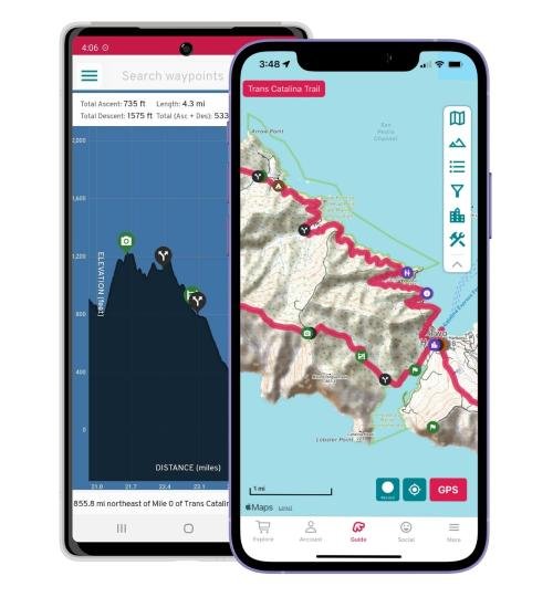
We used the FarOut Guides Trans Catalina Trail app and found it useful for those areas. In addition, the app has crowd-sourced comments that allowed us to know when water spigots were turned on, the hidden side-trails to viewpoints, and where to watch for wildlife.
ROUGH TERRAIN / SCRAMBLING / ROCK CLIMBING
The Trans Catalina Trail has sections on old dirt roads that are VERY steep. We recommend trekking poles to steady yourself, especially if it is muddy.
While there are some steep drop offs, they typically happen when you're walking on a wide, old dirt road, so it's possible to get far from the edge.
The one spot where exposure for height may be an issue is along the ridge from Little Harbor near White Bluff to the high point at the picnic tables. However, it's possible to walk a pleasant dirt road that avoids this area if you or a pet would feel more comfortable doing so.
There is limited shade on the TCT so plan your days accordingly and bring a sun umbrella.
ELEVATION GAIN / ELEVATION LOSS
For a shorter thru-hike, the TCT has a significant amount of total elevation gain at about 11,178 feet over 38.8 miles.

PERMITS AND CAMPING RESERVATIONS
You'll need campsite reservations to backpack this trail.
A free hiking permit comes with your camping reservations.
Book through the Catalina Island Conservancy, which is the private non-profit organization that manages and administers the island and its trails.
They unveiled a new reservation system a few years back. Under the new system, campers individually select a campground for each night on trail and add it to their cart and then check out to reserve their sites.
Since it is a private organization, their system is different from recreation.gov, which is the booking website for hiking and camping permits on public land.
Know your itinerary ahead of time to help make it easier. See our section below for several proposed itineraries.
What to know about Trans Catalina Trail Campsites
Each campsite is about $33-43 per person, per night. You’ll likely need at least three nights to complete the trail (4-5 days is standard).
Each campsite has a different capacity, ranging from 4-12 people.
No matter how many people are on the reservation, each person is required to pay the nightly fee.
Pro tip: reserve your sites early before everyone in your party is confirmed for the hike. Then, as people confirm, add them to the permit and pay their additional camping fee.
On weekends, there is a two-night minimum EXCEPT for Trans Catalina Trail hikers. You need to call Visitor Services at 310-510-4205.
When you're in the system, you can book multiple sites on consecutive dates by updating your search availability and adding the sites to your cart.
Additionally, you have the option to purchase a locker at different sites that will provide firewood and water at around $27/each. Some sites don't have running water, so it is essential you at least get the water.
At some sites, you also have the option of having a fuel canister delivered to your site.
EASTBOUND VS. WESTBOUND
Westbound (START IN AVALON, END IN TWO HARBORS)
Pros:
Option to take the mainland ferries that leave from Long Beach or San Pedro
More ferry options especially later in the day and during off-season months
Can resupply at Two Harbors store before starting the loop to Parson's Landing Campsite
Can make the trip shorter by ending at Two Harbors and either taking the ferry back to the mainland or the shuttle back to Avalon
Cons:
Difficult climb from Avalon to Black Jack
Eastbound (START IN TWO HARBORS, END IN AVALON)
Pros:
It's cool to end in Avalon since it's a bigger town with more restaurants
Easier to get back to the mainland after your hike is complete since ferries run to Avalon more frequently (especially during off-season)
Cons:
Not as many ferry options to start your hike
You may need to spend a night at the campsite to catch the early morning ferry back to the mainland

ROUTE SUMMARY
Trans Catalina hikers can travel eastbound or westbound. I've hiked both directions. The following is a description of the trail hiked eastbound from Avalon to Two Harbors, then hiking the loop clockwise from Two Harbors to Parsons Landing campsite back to Two Harbors.
AVALON TO BLACK JACK CAMPSITE

The Trans Catalina Trail starts at the Avalon ferry terminal. You'll walk through town for a mile to get to the Catalina Island Conservancy Nature Center. Walk the road to the Hermit Gulch Campground, where the trailhead and single track begin and you'll see your first TCT sign. It's steady climbing up about 1,500 feet on switchbacks to the Hermit Gulch viewpoint, with excellent views out to the ocean and to the town Avalon. From there, you'll walk the ridge with more ocean views until you drop to Haypress Reservoir Park, with restrooms and faucets. You'll begin a series of ups and downs over hills and around ponds that are characteristic of the TCT before climbing to Black Jack Campsite under Black Jack mountain.
BLACK JACK CAMPSITE TO AIRPORT IN THE SKY

The Black Jack campsite is great for sunrise views before getting breakfast at the Airport in the Sky Restaurant. Nearby is the Soapstone Quarry used by the Tongva people for millennia to collect a valuable resource for trade. An information board and interpretative walk starting at the airport allows you to learn more about the indigenous history of this part of the island.
AIRPORT IN THE SKY TO LITTLE HARBOR
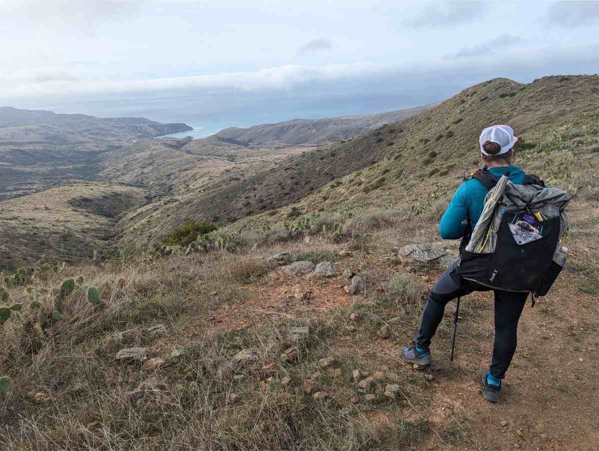
From there, you'll walk Empire Landing Road briefly high on the ridge above the ocean with views to the north before climbing one of my favorite sections of single-track, Big Springs Ridge. I've seen big herds of bison here twice. Be sure to keep your distance and give them a wide berth when walking around them, even if that means leaving the trail. We also saw tiny, endemic Island Foxes here. They're so small, we thought they were cats.
You'll get your first view of Little Harbor from the top of the ridge. With palm trees and green grass alongside the beach, it looks like Hawaii at that campsite–and that's where you're headed next.
Continue on the Big Springs Trail down to the campsite, where you can fill up water bottles and use the toilets before your biggest climb yet.

LITTLE HARBOR TO TWO HARBORS
Switchback up to a narrow ridge right above the ocean. This time, you've got views out to the east where you won't see the mainland or boats but just the views of the open sea and Pedestal Rock off the island. The next few miles are the most exposed and among the steepest and may be closed during and after storms. Though the climbing is physically challenging (and we saw quite a few hikers huffing and puffing), the coastal views looking out to Cat Harbor are the best yet, and arguably are the best of the whole trail. There's a shaded picnic table at the top of the climb and some minor bumps over to a tower before descending to the town of Two Harbors.

TWO HARBORs TO PARSONS LANDING
The campsite at Two Harbors is out of "town center" and up the hill, but the general store and restaurant and ferry terminal are right on the beach. While you are in town: If you're staying at Parson's Landing, don't forget to get the code for your locker at the visitor center. (The locker holds your water and firewood, if you paid for it.)
For many TCT hikers, Two Harbors is the end of the trip and they'll take the ferry back to the mainland. For others, fill up bottles, grab food, use the toilet, take a shower, or do laundry before attempting the northwestern most part of the trip and the most remote hiking of the trail.
Hike towards the quieter Cat Harbor (the second of the two harbors here) on dirt road before starting your biggest climb yet. Pass the Lobster Bay view trail junction and keep ascending on a very steep old dirt road, the Silver Peak Trail. Don't worry–the TCT doesn't climb Silver Peak, instead topping out at a shaded picnic table with views of deep blue water to the north. This whole climb has little shade and can be muddy after a storm. Descend on the steep Fenceline Road to Parson's Landing campsite.
Parson's Landing is a quiet beach campsite that feels more rustic and less resort-y than Two Harbors or Little Harbor. We watched hermit crabs and pelicans and heard seals nearby. It can get windy here with little protection, so keep that in mind while packing. This is also a good spot for swimming.

PARSONS LANDING TO TWO HARBORS
Finish the loop back to Two Harbors via a short bit of single track trail up to good, wide dirt road. This road hugs the coastline past Emerald Bay and Howard's Landing with views of Indian Rock and tucked away coves. We heard a lot of seals here, but you'll need a keen eye to spot them. The road doesn't feel like the most direct route, but private camps prevent shortcuts. Near Lion Head, you'll reach a toilet and sign for Catalina before descending to Two Harbors. Get yourself a drink and a meal before hopping the ferry back to the mainland!
SAMPLE ITINERARIES
This link to a Google Sheet includes options for itineraries.
7-day, 6-night itinerary that allows you to take ferries at any time of day to-and-from Avalon and Two harbors
6-day, 5-night itinerary that requires an early morning ferry to Avalon and a late ferry from Two Harbors
4-day, 3-night itinerary that requires an early morning ferry to Avalon and a late ferry from Two Harbors
4-day, 3-night itinerary that allows you to take a later ferry to Avalon
3-day, 2-night itinerary for very fast hikers that requires an early morning ferry to Avalon and late ferry from Two Harbors
DATA BOOK
Note: this databook does not include many important junctions but instead is included to help you plan your water and distances between facilities. Please carry a map in addition to using this databook.
| Mile from start | Location and facilities |
|---|---|
| 0 | Avalon Ferry |
| 1 | Bird Park (picnic tables, benches, drinking fountain, bathroom) |
| 1.5 | Hermit Gulch Campground (water, bathrooms, showers, soda machine, parking nearby) |
| 1.7 | Official trailhead sign |
| 3.3 | Top of climb shaded benches |
From here, the trail does a loop that begins and ends in Two Harbors. Many TCT hikers choose not to do this loop and stick to the section between Avalon and Two Harbors.
If you head clockwise on the loop, you’ll walk a good (but steep) dirt road out of town from Two Harbors. At mile 28.7, you pass the high point and then descent to mile 30.8 to the Parsons Landing Campground.
| 28.7 | Shaded picnic tables at highpoint |
|---|---|
| 30.8 | Parsons Landing Campground (toilet, water) |
From Parsons Landing Campground, the final 8 miles are a good (mostly flat) dirt road back to Two Harbors. You’ll pass a pit toilet along the way as well as have views out to the ocean until you walk back into town and can celebrate the finish!
| 35.7 | Pit toilet at Goat Whiskers Trail Junction |
|---|---|
| 38.8 | Two Harbors |
MAPS AND GUIDEBOOKS
FAROUT
We downloaded and used the FarOut Trans Catalina Trail guide app and found it incredibly useful for navigating areas around towns and campsites, which often are not well-marked and have many other trails and roads that can make them confusing. In addition, crowd-sourced comments allowed us to know when water spigots were turned on, the hidden side-trails to viewpoints, and where to watch for wildlife.
GAIA
We also downloaded a GPX track of the TCT and pre-downloaded the base maps for the Gaia GPS app before we left. This allowed us to take alternates when 5 miles of the official trail were closed after a storm.
MAPS
The Visitor's Center in Avalon and in Two Harbors sell a paper map of the trail system on Catalina Island for $5. A less-detailed pdf trail system map is available for free on the Catalina Island Conservancy website.
GUIDEBOOKS
We didn't use a guidebook but Plan & Go Trans Catalina books are popular and you can often get them used.
FERRIES TO CATALINA
PORTS ON CATALINA
There are two ports on Catalina Island: Avalon and Two Harbors, which are also the termini of the Trans Catalina Trail.
There are two ferry companies, Catalina Express and Catalina Flyer with service from the mainland.
In summer months, a Cyclone boat runs shuttles between Two Harbors and Avalon.
CATALINA EXPRESS
Catalina Express in Long Beach has service to Avalon only.
Catalina Express in San Pedro has service to Avalon and Two Harbors.
Catalina Express in Dana Point has service to Avalon only.
CATALINA FLYER
Catalina Flyer in Newport with service to Avalon only.
Long Beach has the most options for ferry times.
San Pedro has has the only service to Two Harbors
COST OF FERRY
Expect to pay $84-92 round-trip for the ferry from Long Beach. Additionally, expect to pay $25 per day in parking at the ferry terminal.
Pros and Cons of Starting at Long Beach Ferry Terminal:
Pros:
more options for ferry times
better access to terminal by public transportation
easier access via airport
Cons:
overnight parking is expensive
not as many trips to Two Harbors
May be no trips to Two Harbors during the off-season
Pros and Cons of Starting at San Pedro Ferry Terminal:
Pros:
Only port serving Two Harbors
Cons:
Some ferries serving this port stop at Avalon first, which adds an extra 1:15 to travel time
GETTING THERE
This section is dedicated to getting to the Long Beach Ferry Terminal or the San Pedro Ferry Terminal. From there, the section above on Ferries should explain how to get to Catalina Island. The trail starts right at the ferry terminal.
Private Plane
Catalina Island can be accessed by private airplane to Airport in the Sky Airport, which is at mile 12.7. From Airport in the Sky, you can take a shuttle to Avalon or Two Harbors to start the hike. When you are finished with your hike, you can take a shuttle back to your plane.
BY COMMERCIAL PLANE
Fly to Long Beach Airport
From Long Beach Municipal Airport (LGB), you could take a 15-minute Uber or the Long Beach Transit bus #111 to the Long Beach Ferry Terminal. It's also a 3-hour walk through town, if you want to get in more miles. Long Beach is a great walking city and you can even do about half of those miles along the beach trail. Whatever you do–if you fly to Long Beach, we do not recommend renting a car for this hike as it costs $20 per day to park at the ferry terminal.
Fly to another LA-area Airport
Here are a few options:
Los Angeles International Airport (LAX)
From LAX, you can take the Flyaway Bus to Union Station and the Metro light rail A-Line to Long Beach Ferry Terminal. From Union Station, you can also take the Metro J line bus all the way to San Pedro Ferry Terminal. Either way, it's a LONG ride on public transportation.
You can also take an Uber or renting a one-way car to drop off in Long Beach.
As a Southland resident, I will implore you DO NOT ask a friend or family member to pick you up at LAX. The traffic is so bad around LAX that most people who live in LA wouldn't even pick up their own mother from this airport.
Hollywood Burbank Airport (formerly Bob Hope) (BUR)
Ontario International Airport (ONT)
John Wayne Santa Ana Airport (SNA)
We recommend doing a rideshare or renting a car one-way from any of these airports. Without traffic (usually mid-day) it can take 45-minutes to an hour. With traffic, you could spend more than 3 hours.
You could also string together a long series of public transportation to get to Long Beach or San Pedro Ferry Terminal. We wouldn't recommend it, though. Burbank's public transportation is the most straightforward (Metrolink to Union Station, Metro light rail A-Line to Long Beach Ferry Terminal).
BY CAR
Directions to Long Island Ferry Terminal:
Take I-710 S toward Long Beach. Take exit 1C toward Downtown Long Beach/Convention Ctr/Aquarium. Take the exit toward Golden Shore/Catalina Landing/RV Campground. Continue on W Shoreline Dr. Drive to Golden Shore, where you'll see the parking area for the terminal.
Directions to San Pedro Ferry Terminal:
Take I-710 S toward Long Beach until it becomes Seaside Fwy. Take exit 1C for Harbor Blvd toward Catalina Is/Ports O Call Village/San Pedro following signs for the San Pedro Catalina Express Berth.
TRAILHEADS
Once you're on Santa Catalina Island, the TCT can be accessed from many access trails across the island. The Wildlands Express bus can drop you off at the Airport in the Sky, Black Jack junction, or Little Harbor.
AVALON FERRY TERMINAL
Take the Catalina Express from Long Beach or San Pedro to the ferry terminal in the town of Avalon.
TWO HARBORS FERRY TERMINAL
Take the Catalina Express from Long Beach or San Pedro to the ferry terminal in the town of Two Harbors.
AIRPORT IN THE SKY
The Wildlands Express bus can drop you off at the Airport in the Sky or you can fly a private plane here. Located about halfway through the TCT, this is a good spot if you want to hike half the trail.
FAVORITE RESTAURANT
I highly recommend the Airport in the Sky Restaurant. They are very hiker friendly. The comfy couches, fireplace, scenic patio, and resident cat named Dusty all make the atmosphere A+.
Prices aren't bad considering everything has to be brought over from the mainland. The bison tacos were excellent.
Avalon has numerous restaurant options, though many are expensive (which makes sense since everything has to be brought from the mainland).
REGULATIONS
Follow Leave No Trace Ethics
Dogs are allowed but must be on leash
Group size must be limited to 8 people or less per campsite
Carry a printed and signed version of your permit on your person at all times.
Respect wildlife–especially the American bison–that can be quite aggressive. Give them a wide berth.

RESUPPLY
Before you get to Catalina Island, there are grocery stores in:
Long Beach: There are several grocery stores ~1.5 miles from the Catalina Express ferry terminal including the Long Beach Grocery Co-op and chain supermarket Vons
San Pedro ferry terminal: There's a Family Dollar and small markets 1.3 miles from the terminal.
On Catalina Island:
Avalon: well-stocked grocery store
Airport in the Sky: can get a meal here and if you really need a few snacks, can get them here, too.
Two Harbors: well-stocked grocery store

CAMPING
The main campgrounds on trail are:
Hermit Gulch (has flush toilets and showers).
Black Jack Campground
Little Harbor / Shark Harbor
Two Harbors
Parson’s Landing
Each campsite has flat spots and room for several tents.
All but Parson’s Landing have drinking water. Black Jack campground may have faucets or bottled water. You must pay extra for water at Parson’s Landing.
You can pay extra for firewood delivery to campsites where fires are allowed. Respect fire bans.
Each campsite has picnic tables and a fox box to protect your food. They also have trash and recycle bins. The campground has a pit toilet or port-o-johns with toilet paper and hand sanitizer. Some campgrounds have camp hosts.
I address how to get a campsite reservation and the costs in the section on Permits and Camping above.
WATER PLANNING
TCT hikers should plan on drinking water from faucets and bottled water reserved at campsites for campers. Naturally occurring water on the island is seasonal and unreliable. In my trips on the TCT, I brought a filter but never used it.
Parson's Landing campsite does not have tap water available. Be sure to pay for bottled water to be cached for you there.

WILDLIFE AND FOOD STORAGE
There are no bears on Catalina Island. However, the Island Fox is sneaky and steals food, often in plain sight. Each campsite has Fox Boxes to store food. See REI’s Food Storage story for more ideas on being wildlife-safe.
SIDE TRIPS
Some TCT hikers add an optional side trip on the northern part of the island to Silver Peak and Starlight Peak. This adds about 7 miles.

ABOUT THE AUTHOR / WHY YOU SHOULD TRUST US
Liz Thomas is a former Fastest Known Time (FKT) record holder on the Appalachian Trail, she has also hiked the PCT and CDT and is a Triple Crowner. She’s co-founder and editor-in-chief of Treeline Review. You can read all her gear articles here and on her personal website. You can read more about her on her Wikipedia page.


