Buckskin Gulch and Paria Canyon Backpacking Guide
Wire Pass to Lees Ferry via Buckskin Gulch and the Lower Paria River Gorge with White House Campground and Buckskin Trailhead Alternates

February 22nd, 2026
Home > Trip Guides > Thru Hikes For Working People
Buckskin Gulch is one of the longest slot canyons in the world. Paired with the hike down the Paria Canyon, this 57-mile backpacking trip is considered one of the best desert canyon hikes in the world. Located in the Paria Canyon-Vermilion Cliffs Wilderness, you'll hike along the border of Southern Utah and Northern Arizona.
There are twisty, red, and gray geologic layers; water-sculpted narrows; and tower-like cliffs. Wire Pass, Buckskin Gulch, and the Paria Canyon are great natural world wonders. Petroglyphs show that this has been a special place for humans since time immemorial. Backpacking the canyon is made all the more special by fully immersing yourself in its beauty as a hiker on foot.
I've backpacked Buckskin Gulch three times from both the Buckskin Gulch Trailhead and the Wire Pass trailhead. I've also backpacked the Paria River to Lees Ferry and White House Trailhead and Campground. Here are hiking tips, permits and logistic information, and my backpacking guide for Buckskin Gulch and Paria Canyon.
Distance: 42 miles (Wire Pass to Lees Ferry with shorter variations)
Days: 3 to 5 days
Elevation gain/loss: ~2000 feet/-2500 feet, depending on use paths taken (the route generally loses 1700 feet but requires climbing up and up to 100-foot tall obstacles, so it adds up)
Max elevation/lowest elevation: 4,883 feet (Wire Pass trailhead) / 3,885 feet (Lees Ferry trailhead)
Best season: Spring
Permits: Required for overnight stays, possible to day hike portions of the canyon (see Alternates below)
Difficulty: Moderate for length, but varies depending on water levels


We create reader-supported, objective, independently-selected gear reviews. This story may contain affiliate links, which help fund our website. When you click on the links to purchase gear, we may get a commission, without costing you an extra cent. Thank you for supporting our work and mission of outdoor coverage for every body! Learn more.

The narrow slot canyon of Buckskin Gulch goes on for more than ten miles.
Background Info: Buckskin Gulch and Paria Canyon from Wire Pass to Lees Ferry
Located in the Paria Canyon-Vermilion Cliffs National Monument along the Arizona-Utah border, Buckskin Gulch is a tributary of the Paria River. The two waterways connect and can be paired into one of the best backpacking trips in the world. Among the most hikeable slot canyon in the United States, they are non-technical canyons that rarely, if ever, require ropes or webbing. Their relative flatness and few scrambling sections also make them excellent for backpacking. Buckskin Gulch and Lower Paria Canyon are in the Paria Canyon-Vermilion Wilderness and near the new Escalante National Monument in southern Utah. For further info on the area, check out our guide to the Escalante River and Coyote Gulch Canyon Country.
This area is the ancestral land of the Nuwuvi (Southern Paiute), Pueblos, and Núu-agha-tʉvʉ-pʉ̱ (Ute) and remains an important landscape for the descendants of the original stewards of this land. Throughout the canyons, you will see petroglyphs, moki steps, granaries, and campsites of Ancestral Pueblo.
Respect the land they stewarded and the people who walked and lived in these canyons since time immemorial. Never touch, remove, or mark petroglyphs you may see. Before you go, you can learn more about Native perspectives and causes important to today's Nuwuvi (Southern Paiute), Pueblos, and Núu-agha-tʉvʉ-pʉ̱ (Ute) who still live in the surrounding area. Some topics include sovereignty, honoring treaties, and conservation of Bears Ears and Escalante Grand Staircase National Monument.

Buckskin Gulch is sometimes not more than a few human’s wingspans wide.
Highlights and Challenges
Highlights
The longest slot canyon in the world, with incredible views of twisted rock at every turn
Fun scrambling, water crossings
Relatively flat walking
Accessible without technical gear or ropes
A surprising amount of solitude for a world-class destination, especially in the lower Paria Canyon
Powerful to walk through an area with so much history and cultural significance, especially viewing petroglyphs
Challenges
Flash floods can happen any time of year, and if they do, you'll be in extreme danger
Limited to 20 people overnight backpacking in the canyon per day, so it is tough to get a permit
Very limited drinking water for the first 20 miles and then muddy and silty water for much of the rest of the canyon
In fall and spring, canyons are cold and shaded
You'll be walking through ankle-to-crotch-deep water
You may have to wade or swim through deeper sections of the canyon
Water is very cold and muddy, so it’s hard to tell how deep it is
Quicksand can make walking slow and difficult
No cell service inside the canyon
Being at altitude in the high desert may be challenging for some people
Water and the dangers of canyon travel can be a challenge

The Lower Paria Canyon can get exposed to the sun, so this hike is best done in the spring.
Best Season
April through May are typically the best months to visit Buckskin Gulch and Paria Canyon. You may encounter cold, deep water in the slot canyon earlier in the season. Flash flood danger in winter and March can be extreme. Finding fresh drinking water can be an issue later in the season as springs in the lower canyon may be dried up.
Temperatures at the canyon floor and deep in the slot canyon tend to be cooler than the ambient temperature on the surface or lower canyon. While April and May may seem late at the surface, it'll generally be comfortable or even cold in the canyon. Later in the season, sun exposure and heat may be an issue in the lower Paria canyon, which is so wide that the canyon walls won't shade you. At Lees Ferry, temperatures average above 100 F at the end of June. Horse flies may also be an issue in the Lower Paria River in early summer.

The ladder at Wire Pass is the first of many chockstones you may encounter in the slot canyon.
Difficulty and Skills Required
Navigation
There are no marked trails or signs in Buckskin Gulch or the Paria River canyon. However, navigation is relatively straightforward in Buckskin Gulch and upper Paria Canyon. Things get trickier when the canyon widens towards Lees Ferry in the lower canyon. The canyon in these areas is wide enough that finding the trail can be more difficult. However, if you stick to the river (and between the canyon walls), you'll get there, even if it involves a few more bushes.
Additionally, water sources and campsites are not signed or marked.
Rough Terrain/ Scrambling/ Rock Climbing
Buckskin Gulch is a notable Utah slot canyon that doesn't require technical skills or equipment. Ropes or slings aren't required, and most hikers don't carry them. There is at least one spot with a fixed rope. However, the Bureau of Land Management and other land administrators do not certify their reliability. According to the BLM brochure, ropes are "placed at obstacles without the knowledge or support of the BLM." You may need to crawl up or around boulders. There is at least one ladder in the early part of the Coyote Wash through Wire Pass, starting at the Wire Pass trailhead, though there is a bypass trail during high water.
Swimming/ wading/ fording
There is often little water in Buckskin Gulch. Early in season or during high water years, you may swim. You may need to float on an inflatable sleeping pad. In the lower Paria Canyon, there's a lot more water. The trail constantly crosses the river back and forth. You may even consider a packraft in higher years. In low years or later in the season, you may not even get your knees wet during fords for the entire length from Wire Pass to Lees Ferry.
Elevation gain
The route is relatively flat with a slight downhill angle. Over 50 miles, you'll lose 1,750 feet. However, especially in the lower Paria Canyon, there are micro ups and downs as you go down the river or back up the riverbank.
Limited water and long carries
There is very limited drinking water for all of Buckskin Gulch. There are often some seeps at the Confluence, but it may involve filtering silty or muddy water. Besides the Confluence, there is often no spring water for the first 10 miles of the Paria River. That translates to almost no spring water for the first 20 miles. For the entire length of the Buckskin Gulch hike and the Paria River after, water can be muddy and silty water. It can very easily clog water filters. You should also not consume water from the Wilson Ranch area as it contains uranium.
Water sources are not signed or marked. In the case of some water sources, they can be challenging to find and located behind bushes, rocks, etc.
You will have to walk or possibly swim through cold, muddy water
Walk/Swim through cold, muddy water
In fall and spring, canyons are cold and shaded, and you'll walk through ankle-to-knee-deep water. Buckskin Gulch is the natural waterway of a tributary to the Paria River.
You may have to wade or swim through deeper sections of the canyon. Waterproof your pack—especially your sleeping bag and electronics. Have extra dry clothing in case all of your equipment gets wet.
Water is very cold and muddy, so it's hard to tell how deep it is—test water depth before heading in.
Mud
Quicksand can make walking slow and difficult. I've lost a shoe and had to retrieve it.
Flash Flood Danger
Flash floods can happen any time of year; if they do, you'll be in danger. No cell service inside the canyon makes a rescue even more difficult. Even satellite transmitters are not reliable in all parts of the narrow canyon.
Flash floods are most common between July and August. However, in spring 2023, they happened in March, resulting in rescues and fatalities.
Always check the weather before you go. Do not just check the area along the canyon—also check the headwaters of the Paria River near Bryce Canyon. Flash floods can travel from many miles away. Water from that area can take 10 hours or more to reach Buckskin Gulch and put hikers in danger.
As you hike, always look for high ground. During a flash flood, get to the highest point you can reach until the water subsides. Flash floods are scary and can be deadly. Sometimes, finding high ground isn't enough to stay safe. If you check the weather report and you see any chance of rain, or if it has rained recently, consider postponing or canceling your hike. This is not a comprehensive list of the places to check, but is a good place to start:
NWS Salt Lake City UT weather.gov/saltlakecity
Flash Flood Warnings Utah Paria Canyon https://www.weather.gov/slc/flashflood
BLM Active Advisories and Alert https://www.blm.gov/alerts
Temperature Variations
There is little sun deep in Buckskin Gulch, and it can feel cold. The water itself can be frigid. Farther down the canyon towards Lees Ferry, the canyon opens up, and the sun exposure and heat can be exhausting. Bring sun protection such as a sun shirt, sun hat, hiking sun umbrella, and plenty of sunscreen. Be prepared for both extremes of the temperature range.
Wag bag restrictions
You are not allowed to bury your poop or any waste in Buckskin Gulch or Paria Canyon. Due to the limited space and slow decomposition in this desert climate, this is essential to keep the canyon clean. The BLM will give you 1-2 excellent WAG bags. These WAG bags allow you to pack out your human waste without odor or mess. They take a bit of time to learn how to use, so learn how to use them before you go and even consider practicing at home. See our guide to the Best Human Waste Bags and Wag Bags for our recommendations.

The lower Paria Canyon has the same permit restrictions as Buckskin Gulch, though it is less popular and covers many more square miles.
Permits
Permits are released 3 months out for the entire calendar month of hiking. You can get them at recreation.gov.
For example, January 1st at noon is when they open all the permits for April.
February 1st at noon is when permits for all permits in May open.
December 1st is when all permits for March open.
Permits open at noon, and plan to be logged in, know your itinerary and campsites, and be prepared for flexibility. Practice on recreation.gov before the 1st of each month.
The permit system is laid out here. These permits are incredibly competitive to get. Overnight permits are limited to 20 people each night for the entire canyon. That means it doesn't matter whether you camp between Wire Pass and the Confluence or deeper in the canyon closer to Lees Ferry. They mean people camping anywhere from Wire Pass or Buckskin Trailhead to Lees Ferry—not 20 parties. That means one big group could take up half the permits.
You must pick up your permit in person at the BLM office up to two days before your trip. There's a BLM office in St. George, Utah (a city about 2 hours away from the trailhead). There's also one much closer to the trailhead. You will not be able to print your permit at home. Only a permit issued at these offices is valid. They'll also give you a primo wag bag.
If you can't get an overnight permit, you may consider hiking part of the canyon as a day hike—which we outline in the Alternate Routes section below.
Day hiking also requires a permit. You can get on your Smartphone using a QR code at the Wire Pass trailhead. There are no visitor use limits for day hikes. Note that when I was there, it took almost 20 minutes for the page to load and to get enough reception for it to go through, but it finally worked. There is a ranger or volunteer there who may be able to help you, but they cannot accept cash for payment for your permit.
Display your day-use permit on your vehicle windshield. Rangers frequently check unauthorized day use and overnight parking at the Wire Pass trailhead. Display your overnight permit on the dashboard of your vehicle.
The day-use permit does not include Coyote Buttes North (which goes to The Wave) or the Coyote Buttes south.

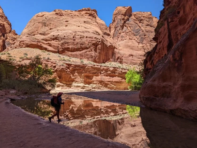
Hiking along the Paria River in the canyon after the Confluence with Buckskin Gulch.
Route Summary
Start at either the Wire Pass Trailhead or Buckskin Gulch Trailhead. I've started backpacking trips from both trailheads, and they both are incredible. The two trailheads are 3.8 miles apart via House Rock Valley road. The two trails intersect after a few miles of hiking.
If you start at the Buckskin Gulch Trailhead, you'll meet up with the Wire Pass trail after 4.8 miles. The Buckskin Gulch trailhead is neat because you gradually watch the canyon wall around you become steeper and steeper until you look around and find yourself in a slot canyon. Plus, you'll see some bighorn sheep petroglyphs along the way.
The 1.7-mile hike starting at the Wire Pass Trailhead is more fun because it takes you from the mouth of Coyote Wash right into the heart of a narrow slot canyon at Wire Pass. After about half a mile, Coyote Buttes and The Wave trail veer off. Then you encounter an exciting chockstone with a 3-10 foot drop. There's a ladder at the Wire Pass slot canyon itself and a high water route option in case the slot canyon is flooded.

The open area where the Wire Pass Trail and Buckskin Gulch Trail meet, with an alcove (a semi- arch) in the background and the narrow crack of the slot canyon of Wire Pass in the background.
Whichever trailhead you start at, when the Wire Pass Trail and Buckskin Gulch Trail meet up, there's a wide open area with a notable wall covered in etchings of bighorn sheep. Getting to this amphitheater surrounded by red rock cliffs is one of the most impressive day hikes you could do anywhere. It's well worth the out-and-back if you're in the area.

An old ladder is stuck tens of feet above the surface, giving you an idea of how high water can surge in the canyon during flash floods.
The rock starts turning red from here, and the canyon really narrows. The next few miles are going to wow you with colorful geology. The following 12 miles average between 12 and 16 feet wide, so it is not for the claustrophobic. Logs will jam high above you, wedged and suspended in the canyon. You'll be 50-100 feet and sometimes 300 feet below the canyon rim, so water can get deep when the river flows. You can see why it is imperative to have a good weather forecast before entering the canyon.
About 8 miles in, you'll start encountering deeper pools of cold, muddy water. Since the canyon gets little light, water can't evaporate. About 9.5 miles in, you'll reach the Cesspool, the deepest of these puddles. I've had to wade through thick, muddy water here. Occasionally, hikers have to swim and float their gear on an inflatable backpacking pad.
About 10.5 miles in the canyon opens up. If it's been cold in the canyon, this is typically a warmer area that gets more sun exposure and is a good place for lunch. The map indicates that the Middle Route exit can lead to the north rim in extreme emergencies, such as a flash flood. The National Geographic map calls it "extremely hazardous. Technical climbing skills or equipment may be required." You'll see the Bear Paw petroglyphs, big horn etchings high on the walls above you, and Moki steps used to get across the canyon by ancient peoples.
After 4.1 miles, you'll reach a boulder jam called The Rockfall. It's different every time I've hiked this trail. Each time, there's been a 10-15 foot drop. Sometimes there is a giant puddle. Sometimes there is a non-BLM-sanctioned rope (use at your own risk). One time, there was a dead bighorn sheep underneath it. This part of the hike is considered by many to be the most technical. If you aren't sure what to do, wait until another hiker comes your way to spot you or help get your pack down. Some hikers carry a rope to lower their pack here. There are a few campsites about half a mile down the canyon.

The walls of Buckskin Gulch can block out the sun for most ot the day, making the water inside feel quite cold.
After another 1.5 miles, the canyon widens, and there are some campsites before the Buckskin Gulch Confluence with the Paria River. This area can get crowded though, so you may have company. You may start to see some water that looks less muddy or silty. Even a few trees may grow along the side of the canyon. It is sometimes closed to camping to restore vegetation, so if you plan to camp here, check with the ranger first.
The Confluence is a magical spot. If you turn left and follow the Paria Canyon upstream, it's 7 miles to Whitehouse Campground. This point is the exit for those doing the White House Campground Variation (See Alternates below for a description of this route).
Otherwise, continue right to the Lower Paria River and into the Paria Narrows.
The Paria River gorge is comparatively much wider than Buckskin Gulch. The walking is more pleasant with more sun to warm you (though warning: it can get hot towards the end). Aside from GPS (which doesn't always work in the Paria Narrows part of the canyon), you can count the 4 cracks in the canyon to track where you are.
There's more light in the Paria River section, so taking photos is also easier. The farther you get, the more the red rock makes it look like a mini Grand Canyon. The route crisscrosses from one side of the river to the other as canyon walls get close to one bank or the other.

Ferns grow on walls where fresh water seeps flow. They are often a sign that you are near fresh water that will not be silty or muddy like the water of the Paria River.
There are springs of fresh water and numerous seeps of fresh water from here on out. Before the First Crack, you'll see ferns growing near springs like Wall Spring.
As you walk the canyon, you'll see alcoves. These are undercuts or overhangs in the cliff, like arches attached to a cliff. They are impressive to walk under and like a cave.
One of the joys of the Paria River is the twists and turns. There are a few abandoned meanders that some hikers explore. These are old abandoned stream channels made from former oxbows in the river.
Expect to constantly cross the river and wet your feet as you ford from side to side. It is usually ankle-deep, clearer, and warmer than in Buckskin Gulch. The farther down the river you go, the deeper water will get.
Before Second Crack, you'll see trees and more campsite options, like those near Big Spring. In an emergency surge in the river, it's easier to get to higher ground.

Deep in the heart of the Paria River Canyon, the rock changes. Old meanders, where the river once flowed, create interesting side trips for hikers.
There are petroglyphs throughout the Paria River. Bighorn sheep live high in the canyons and are subjects of the art. Refrain from eating or camping near petroglyphs and don't touch, mark or remove petroglyphs you see. To preserve the cultural resources, I won't go into more detail on where to find them in the canyon—but there are many notable and impressive panels and boulders in the lower Paria Canyon. From here, the canyon starts to widen more. There will be many seep options—freshwater that isn't silty to treat and drink. They aren't full springs but are still decent water sources.
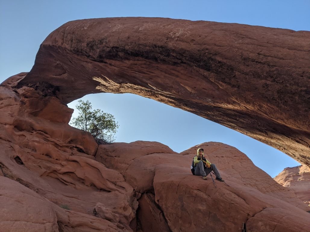
There are steep exits out of the Paria River up Wrather Canyon 13.5 miles from the Confluence) and Bushhead Canyon (19.5 miles from the Confluence). Weather Canyon is a stream that parallels the Paria River; you likely won't miss it. Follow it up, and there's a rough "hiker trail" to Wrather Arch as a side trip (no camping allowed).
Shower Spring is about a mile and a half downstream, a reliable and difficult-to-find pool behind willows on the canyon's left (north) bank. It's across from a large and lovely willow-protected campsite.
You'll reach an optional high water route at 21 miles in. The rock around here changes, and the river channel cuts deeper, so this alternate is sometimes necessary. Above you, to the south, is a hanging sand dune. Nearby is one of the best petroglyphs in the canyon. About a mile after is the Last Reliable Spring, so fill up for the rest of the trip!

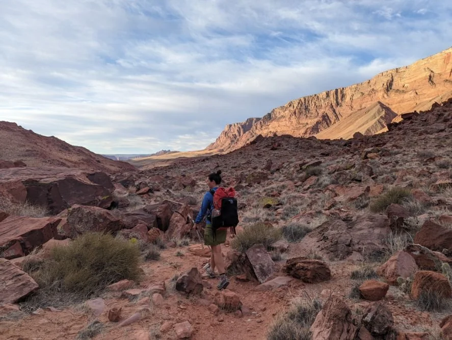
The lower Paria Canyon near Lees Ferry gets very wide open with incredible views. It also can get quite exposed to the sun.
It's incredible to watch the Paria canyon go from the width of a human's wingspan to an expanse as vast as the eyes can see—within a few days' worth of walking. There's so much human history here, and it's a powerful feeling to walk a route many others have visited before.
After Bush Head Canyon, you'll be on a hiker trail, generally following the south side of the river. You can stay on that side for a few miles—a first on this trip! There's a maze of trails through here—some of which cross the river more than others. The canyon is a lot wider, and you have options. You'll see some large boulders that you'll have to go around, including etchings by F.T. Johnson, a cattle herder. There are impressive petroglyphs among these boulders as well.
At 26.3 miles in, you'll see remnants of the old Wilson Ranch, which just looks like a falling apart stable on your right. Don't drink water from around here, as water tests show there is uranium. You're only 6 miles from the end, so you can make it! You can learn more about radium in drinking water from the CDC here.
31.4 miles from the Confluence (and 44 miles from Wire Pass), you'll reach the Lees Ferry parking lot near the Lonely Dell Ranch exhibition site. This location is near where the Paria River meets the Colorado River and is a special site. You've successfully hiked from Wire Pass to Lees Ferry!

The upper Paria River Canyon (here) is wide enough that you may get some GPS coverage. Deep in Buckskin Gulch, you may not be able to get a GPS signal.
Maps and Guidebooks
Gaia
I used the Gaia GPS app on my phone. Although the GPS on my phone didn't always work in the Buckskin Gulch, Gaia was very useful in finding springs in the Paria River portion of the trip. It also helped me track how far down the canyon I had come and get ideas of potential camping areas.
Maps
I carried the National Geographic Paria Canyon, Kanab covering Vermilion Cliffs National Monument and Grand Staircase-Escalante National Monument.
It helped me get a general overview of nearby landmarks and my position along the canyon. It includes the springs, several exit routes, and connected trails. It also includes the wilderness lines and boundaries for Vermilion Cliffs Wilderness.
Guidebooks
Michael Kelsey's Hiking and Exploring the Paria River is the definitive text and is highly recommended. It includes details on all routes, driving directions, history, geology, and notes about petroglyphs, etching, and Native peoples.

One of the most notable alcoves in the upper Paria River after the Confluence. It’s a nice place for a lunch break.
Getting There
By Plane
The closest major airport is Las Vegas International Airport (LAS). There's lots of rental car options here for getting a vehicle to cover the remaining 4.5-hour drive to the Paria Ranger Station.
Cedar City Regional Airport, Utah (CDC) is the closest airport. It has very limited service, mostly with connections in Salt Lake City. You can get a rental car for the remaining 2-hour drive to the Paria Ranger Station.
Flagstaff Regional airport (FLG) is a mid-sized regional airport and is the closest airport to the Grand Canyon. It's much bigger than Cedar City airport, with more options for flights. You can get a rental car from here for the remaining 2.5 hours drive to Wire pass. It's also a good option for sightseeing at the Grand Canyon.
Salt Lake City International Airport (SLC) is another option for a major airport. You can get a rental car from here for the remaining 6-hour drive to Paria Ranger station. This option is good if you plan to do some Utah National Park sightseeing along the way. Zion National Park and Bryce National Park are not far from the route you will take.
By Car
Get your permit at the Paria Ranger Station and Visitor Center. Halfway through Page and Kanab between mileposts 20 and 21 on Highway 89. Check for the latest weather and hiking conditions before you start to make sure flash floods will not be an issue. There's a tank for drinking water here.
There are 4 entry points to the Gorge from Highway 89. No trailhead has water. See Trailheads section below.
Shuttle Services
Call for reservations and check availability way in advance.
Paria Outpost and Outfitters also has camping (for a fee) at their site located near White house Campground and the Paria Canyon Ranger Station. They can shuttle between Whitehouse Campground and Wire Pass but can no longer shuttle to Lees Ferry due to permit issues with the National Park Service.
The following outfitters offer shuttles between Wire Pass, Whitehouse Campground, and Lees Ferry. I haven't used these services, so I cannot vouch for them.
buckskin Gulch and Paria Canyon Trailheads
There are four entry points from Highway 89.
Buckskin Trailhead
From Highway 89, turn south on House Rock Valley Road for 4.6 miles and park on your left. House Rock road is a hard-packed dirt road that is generally well-maintained but can sometimes get flooded.
Wire Pass Trailhead
From Highway 89, turn south on House Rock Valley Road for 8.4 miles. A large parking lot will be on your right. You cannot camp at the trailhead.
White House Trailhead
White House Campground is the main entrance for Paria Canyon (if not adding on Buckskin Gulch). It's at the end of a gravel road and is usually accessible in all weather conditions. From the ranger station, drive 2 miles on a good gravel road. The Campground has a fee and only a few spots. There are picnic tables and fire rings but no water.
Lees Ferry
Lee’s Ferry is located on the Colorado River near Jacobs Lake and Page, AZ near Lake Powell. It's also near Horseshoe Bend on the way back to pick up your car at Whitehouse Trailhead or Wire Pass, so it's well worth a stop (note: there is a user fee to enter).
From Marble Canyon and the Navajo Bridge on Highway 89A, take Lees Ferry Road 5.2 miles past the Lees Ferry Entrance center, Balanced Rock, the Lees Ferry Ranger Station, and the Campground. Turn left on Lonely Dell road towards Lonely Dell Ranch. A quarter mile up the road you'll see a gravel parking lot and trail leading to the ranch. That's your trailhead!

Many people consider petroglyphs to be sacred. Not only is it respectful to never touch, mark, or remove petroglyphs, but it is a federal crime to do so.
Regulations
Follow Leave No Trace Ethics. Pack-it-in, pack-it-out for all trash, food scraps, and toilet paper.
Human waste bag required. You are not allowed to bury your poop or any waste in Buckskin Gulch or Paria Canyon. Due to the limited space and slow decomposition in this desert climate, pack out feces in a human waste bag.
Campfires prohibited. Do not build campfire rings or campfires.
Never touch, remove, or mark petroglyphs you may see.
Carry a printed and signed version of your permit on your person at all times.
Dogs are allowed but must be included on your permit. You must pack out all dog waste. Dogs must be leashed in Glen Canyon Recreational Area (the last 2 miles before the Lees Ferry trailhead). This is conditional and may change.

Quicksand and loose mud can be a challenge of Buckskin Gulch and Paria Canyon.
Water Planning
Water sources are far apart and unreliable.
There are no reliable water sources from Wire Pass Trailhead or Buckskin Gulch Trailhead to The Confluence with the Paria River. Plan to carry enough water for 22 miles of hiking. You may encounter some very muddy and silty water but do not rely on it.
From the Confluence, you'll have more water options. The Paria River varies in siltiness, saltiness, and appetizingness depending on what the upstream farmers are doing. Let muddy water settle overnight before filtering.
However, it is best to plan on the springs for your water sources.
From the Confluence, the freshwater sources are:
2 miles from the Confluence: Wall Springs, aka Little Springs (can dry up early in the season)
5 miles from the Confluence: Big Springs (among the most reliable and hard to miss)
12.5 Judd Hollow Pump. I didn't see this, but it looks like some rusting equipment and is definitely not a functioning water pump.
17 miles from Confluence: Shower Spring (note: this is difficult to find but great water)
17.2 Last reliable spring
Several seeps and seasonal springs are listed in Michael Kelley's book along the Paria River. I've seen some of these during my trips, but I will not list them here since they are unreliable.
Food Storage
There are no bears in the canyon. However, there are some rodents, especially in the lower Paria River. I recommend carrying an Odor Proof sack at a minimum. See REI’s Food Storage story for more information.
Cobra Arch is a side-trip up the Middle Route.
Variations and Side Trips
Getting an overnight permit can be difficult, but hikers taking on bigger miles can experience notable sections of the canyon as a day hike or overnighter. There are no limits to the number of day hikers. There are some areas outside the restricted area where it is legal to camp.
Wire Pass to White House Campground
Many backpackers and hikers hike Buckskin Gulch alone without adding much of the Paria River. They hike from Wire Pass to White House Campground, either as an overnight or a day hike. Many day hikers start at White House and hike up lower Buckskin Gulch as an out-and-back.
Note that you will reach The Narrows 4 miles from White House campground and 3 miles from the Confluence. I've had to swim through the Narrows. You do not want to get caught here at night. Although it's usually fine, you may want an inflatable sleeping pad to float backpacks across.
For those who seek to hike Wire Pass to White House as a backpacking trip, note you are allowed to camp along the Paria River when you are 5 miles from the Confluence and 2 miles away from White House Campground. Transmission lines above you conveniently mark where the BLM Wilderness and National Monument/National Recreation Area boundary ends.
For fast hikers who can complete long days, you may be able to start at Wire Pass and make it to the transmission lines, camp at the transmission lines, and finish at White House Campground. This hike is approximately 18.5 miles. The next morning, it'll be an extra 2 miles to the White House Campground. Extremely fast hikers or runners can do the 28 miles as a day hike. Start early and budget time for shuttling cars! Navigating boulders, scrambling, and deep, cold, muddy water—especially in The Narrows—is not fun at night.
White House Campground to Lees Ferry
Backpackers looking to avoid the technical sections of Buckskin Gulch may choose to start at the White House Campground instead. It's 7 miles from Whitehouse Campground to the Confluence with Buckskin Gulch. You'll pass under the transmission lines two miles from the campground and enter the restricted camping area. Four miles from the campground, you'll reach The Narrows, which may be deep water that requires swimming. 6.7 miles from the campground, you'll see Slide Rock Arch. From there, the route is the same to Lees Ferry.
Buckskin Trailhead or Wire Pass Trailhead Day Hike
If you're looking for a more mellow day hike, starting at Buckskin Gulch Trailhead and making a horseshoe to the Wire Pass Trailhead covers a lot of incredible ground (but requires a car shuttle). Otherwise, an out-and-back from Wire Pass Trailhead and turning right when it meets the main Buckskin Gulch trail is excellent. Walk as far as you'd like and retrace your steps. You'll see some amazing slot canyon geologic features just in those first few miles after it meets up with the Buckskin Gulch Trail.
Gear Rentals
Kanab, UT, has various outfitters and gear stores to help replace last-minute items you may have forgotten.
St George, UT, is the closest bigger town. It has Cedar Sports: outdoor gear and rentals as well as a Sportsman's Warehouse and several other outdoor stores.

Buckskin Gulch and Wire Pass can be quite narrow in some places, so keep that in mind when packing your backpack.
Gear List
I've encountered all sorts of weather in my three backpacking trips on this route. Here are my thoughts on what worked for an April or May backpacking trip to Buckskin Gulch and Paria Canyon.
TENT
We backpacked the Buckskin and the Paria Canyon during dry, warm weather. However, camping the first night on the rim before the trip was windy. While in the canyon, it was warm enough to cowboy camp. There's a lot of sand, so consider a freestanding tent. See our Best Backpacking Tents guide or our Best Ultralight Tents guide for more recommendations.
BACKPACK
We needed a backpack that could handle the heavier loads from the longer water carries. See our Best Backpacking Backpacks guide for recommendations on lightweight packs for comfortably carrying bigger water carries.
SLEEPING BAG
It's easy to forget that even though the desert gets hot during the day, it often gets below freezing at night in the spring. Inside the canyon can be cold. The rim can be cold and windy. Some sections of the lower Paria can be pretty warm. See our Best Sleeping Bags or Best Backpacking Quilts stories for more recommendations.
SLEEPING PAD
We opted for minimalist choices and found that worked well as we were often camping in soft sand. See our Best Backpacking Sleeping Pads story for more recommendations.
TREKKING POLES
The Buckskin and Paria Canyon have a few miles of climbing and rockier sections of trails, so we appreciated having hiking poles. We also used our trekking poles to hold up our lightweight tents. See our Best Trekking poles story for more.
COOKING SYSTEM
A backpacker could easily hike this trail stoveless, but I enjoyed having hot food at night. See our Best Backpacking Stoves story for more recommendations. In addition to carrying a Cooking Pot to boil water, I brought an empty plastic Taleni gelato jar to cold soak my lunches.
WATER filter
I carried a Sawyer Squeeze water filter on this trip and was happy to have something that can quickly purify water so quickly. See our guide to Best Backpacking Water Filters and Purifiers for more recommendations. See our in-depth review of the Sawyer Squeeze water filter based on thousands of miles of thru-hiking and bikepacking for more information.
HEADLAMP
Although I didn't do any night hiking, a bright headlamp was nice in case I had to night-hike through the canyon to find a suitable camping site. If you were to backpack this trail during a warmer season, it might be nice to do some night hiking to escape the heat. See our recommendations in our Best Headlamps story.

The open area where Buckskin Gulch Trail and Wire Pass Trail meet is the beginning of the Buckskin Gulch slot canyon. Pack and dress for sun exposure for the open areas, but also account for much colder temperatures deep in the slot canyon.
WHAT TO WEAR AND CLOTHES TO PACK
SHOES OR BOOTS
Trail running shoes provided the support and stability needed for this backpacking trip. After getting them covered in sand, I found it difficult to maintain traction on rock with my trail shoes. Because there is so much sand and mud, I'd recommend something with good traction. I would highly recommend something quick drying and mesh—not waterproof. You'll be going in and out of the water often. See our Best Trail Running Shoes story.
We saw many backpackers in boots for this trip because sections can be rocky. If you’d feel more comfortable in boots, check out our Best Lightweight Hiking Boots story. I highly recommend quick-drying, non-waterproof versions that will dry more quickly. The water is deep and waterproof boots will not keep your feet dry.
A nice footwear compromise for this trip would’ve been hiking shoes, designed to feel like a trail runner but have stability more like a boot. See our Best Hiking Shoes story for footwear that is more durable and stable than trail runners.
SUN SHIRT
No matter what time of year you hike this trip, you should wear a sun shirt to protect yourself from the intense sun ray exposure. The lower Paria River is very exposed. You're at elevation. See our guide to The Best Sun Shirts for our recommendations.
RAIN JACKET
I do not recommend doing this trail if there is any rain in the forecast due to flash flood danger. Nonetheless, it is good practice to bring rain gear, and you can always use it to cut the wind. For more recommendations, see our Best Rain Jackets article.
DOWN OR SYNTHETIC JACKET
The desert can be up to 40 degrees cooler at night than during the day. The canyon floor of slot canyons is much cooler than the surface. So even if your temperatures look warm during the day, bring a good insulated jacket for time in camp, early morning, and shaded parts of the canyon. Since I knew I'd get wet and possibly even swim, I opted for a warm-when-wet synthetic jacket. See our recommendations in our Best Synthetic Jackets article. If you prefer down for its better warmth-to-weight ratio, check out our Best Down Jackets guide, which should be a good option under most weather conditions.
HIKING PANTS
In our party of two people, one wore hiking pants, and another wore a hiking skirt. Part of this was because it was cool outside while we were hiking. But also, there are many spiky plants in the desert and significant sun exposure, and pants offer extra protection compared to shorts. See our guides to the Best Women's Hiking Pants and Best Men's Hiking Pants for more recommendations.
HIKING SHORTS
If you're hiking during the warmer months, consider hiking shorts. See our Best Men's Trail Running Shorts guide and Best Women's Trail Running Shorts guide for the most minimalist recommendations. Otherwise, see our Best Men's Hiking Shorts guide, our Best Women’s Hiking Shorts guide, or the Best Thru-hiking Shorts guide for a more durable pair.
BASELAYER
Although we wore our sun shirts as our against-the-skin layer, we also had base layers for sleeping at night because the desert night was so cold. For more recommendations, see our Best Baselayers guide.
SOCKS
Desert sand and grit can quickly get into your socks and shoes, so having a tightly woven, well-fitting hiking sock is essential. Additionally, feet can get sweaty during warmer days, so a good hiking sock can wick away moisture and help prevent blisters. Check our Best Hiking Socks guide for more recommendations.
WARM HAT
Again, the desert is cold at night. Bring a warm hat for use during the day and sleeping at night.
SUN HAT AND SUNGLASSES
The sun exposure is intense, especially in the lower Paria canyon. There is limited shade. Check out our Best Sun Hats guide for recommendations. Once you get out of Buckskin Gulch, the sun can be oppressive. Be sure to pack a pair of secure sport sunglasses or Running Sunglasses that will stay on your head during scrambling.
GLOVES OR MITTENS
Because I backpacked this trail during spring and inside Buckskin Gulch is shaded and can stay cold all day, I was happy to have gloves and mittens. See our Best Winter Gloves guide for recommendations.
MISCELLANEOUS GEAR ITEMS
Map and Compass
First Aid Kit
Sun Protection: don't forget lip balm and sunscreen. See our guide to The Best Face Sunscreen and The Best Body Sunscreen for recommendations.
Pocket Knife


